Solar eclipse of January 9, 1834
A partial solar eclipse occurred on January 9, 1834 during summer. A solar eclipse occurs when the Moon passes between Earth and the Sun, thereby totally or partly obscuring the image of the Sun for a viewer on Earth. A partial solar eclipse occurs in the polar regions of the Earth when the center of the Moon's shadow misses the Earth.
| Solar eclipse of January 9, 1834 | |
|---|---|
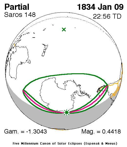
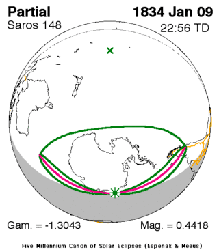 Map | |
| Type of eclipse | |
| Nature | Partial |
| Gamma | -1.3043 |
| Magnitude | 0.4418 |
| Maximum eclipse | |
| Coordinates | 67.8°S 11.3°E |
| Times (UTC) | |
| Greatest eclipse | 22:55:31 |
| References | |
| Saros | 148 (11 of 75) |
| Catalog # (SE5000) | 9124 |
It was one of two partial eclipses that took place that year, the next one was on June 30 in the Northern Hemisphere.[1] It was the eleventh solar saros 148 event.[2]
Description
The eclipse was visible almost throughout Antarctica which had a 24-hour daylight with a tiny exception of the northeast, a part of the southeast portion of the Indian Ocean, the southernmost areas of the Pacific and Patagonia in South America.
The eclipse started at sunrise near halfway between Antarctica and the southwesternmost point of Australia and ended at sunset northeast of Puerto Montt, Falkland Islands or Malvinas and near the South Orkney Islands.
It showed about up to 10% obscurity in Antarctica, 20-25% at the peninsular part and up to 40% in the middle of northern Antarctica. The greatest eclipse was near Antarctica at 67.8S, 11.3 E at the Atlantic at 22:55 UTC (23:55 local time).[1]
The subsolar marking was in the Pacific Ocean.
See also
- List of solar eclipses in the 19th century
- List of solar eclipses visible from Antarctica
References
- "Solar eclipse of January 9, 1834". NASA. Retrieved March 11, 2017.
- "Solar Saros 148". NASA. Retrieved March 11, 2017.
.jpg)
