Solar eclipse of August 16, 1841
A partial solar eclipse occurred on August 16, 1841 during winter in the southern hemisphere. A solar eclipse occurs when the Moon passes between Earth and the Sun, thereby totally or partly obscuring the image of the Sun for a viewer on Earth. A partial solar eclipse occurs in the polar regions of the Earth when the center of the Moon's shadow misses the Earth.
| Solar eclipse of August 16, 1841 | |
|---|---|
 Map | |
| Type of eclipse | |
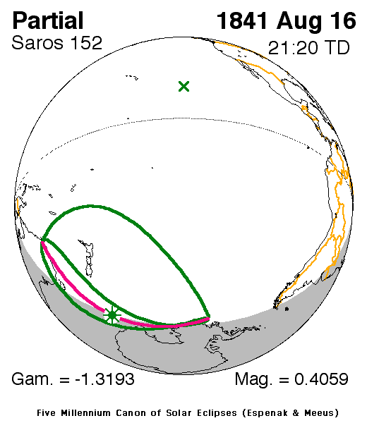
| Nature | Partial |
| Gamma | -1.3193 |
| Magnitude | 0.4059 |
| Maximum eclipse | |
| Coordinates | 61.9°S 158°E |
| Times (UTC) | |
| Greatest eclipse | 21:20:24 |
| References | |
| Saros | 152 (3 of 70) |
| Catalog # (SE5000) | 9142 |
It was last of four partial eclipses that took place that year, two in the space of two months each, the last one was on July 1819 and covered a part of the Northern Hemisphere.[1] It was the third solar saros 152 cycle of eclipses[2]
Description
The eclipse was visible in much of the Pacific Ocean and included New Zealand and other smaller islands including Cook, Chatham, Antipodes, and Norfolk Islands and a couple of others, one of them Macquarrie and Lord Howe.
The eclipse was nearly close to New Caledonia and a part of Antarctica.
The eclipse started at sunrise in Tasmania and southeastern Australia and finished at sunset at the Pacific and a tiny part of Western Antarctica. The greatest eclipse was in the Pacific Ocean hundreds of miles (or kilometers) north of Antarctica at 61.9 S & 158 E at 21:20:24 UTC (8:20 AM local time).[1]
The subsolar marking was in the Pacific north of the 10th parallel north.
See also
- List of solar eclipses in the 19th century
- List of solar eclipses visible from Antarctica
References
- "Solar eclipse of August 16 1841". NASA. Retrieved March 14, 2017.
- "Solar Saros 152". NASA. Retrieved March 14, 2017.
.jpg)
