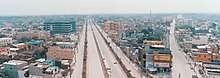
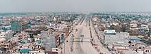
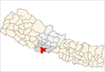
Siddharthanagar
Siddharthanagar (formerly and coloquially still used Bhairahawa) is a municipality and the administrative headquarter of Rupandehi District on the Outer Terai plains of Nepal, 265 km (165 mi) west of Kathmandu Nepal's capital. It is the closest city to Lumbini, the birthplace of Gautama Buddha, which is located 25 km (16 mi) to the west. The city borders the Indian city of Sonauli in Maharajganj district of Uttar Pradesh. The city is among the major industrial power house in the country impacting major economic aspects of Nepal. It has the second largest rate of border trade with India after Birgunj border in the country. Although the current name was first used in 1977,[1] many still refer to it as Bhairahawa.[2]
Siddhārthanagar सिद्धार्थनगर | |
|---|---|
| Nickname(s): Bhairahawa | |
| Motto(s): Hamro Pyaro Sahar | |
 Siddhārthanagar Location in Nepal | |
| Coordinates: 27°30′N 83°27′E | |
| Country | |
| Province | Province No. 5 |
| District | Rupandehi District |
| Incorporated | 1967 |
| Government | |
| • Type | Mayor–council |
| • Mayor | Hari Adhikari (NCP) |
| • Deputy Mayor | Uma Kafle (NCP) |
| Area | |
| • Total | 36.03 km2 (13.91 sq mi) |
| Population (2011) | |
| • Total | 63,483 |
| • Density | 1,800/km2 (4,600/sq mi) |
| Time zone | UTC+5:45 (NST) |
| Postal code | 32900 |
| Area code(s) | 071 |
| Website | |
History and Etymology
The city was founded as Bhairahawa in 1967. was derived from the deity Bhairava a manifestation of Shiva. The city's current name Siddharthanagar derives from Buddha's given name Siddhartha, as the birthplace of Buddha is located only 25 km (16 mi) to the west. The name was changed to Siddhartanagar in 1977[1] by Komal Dutta Tiwari, a poet.
Climate
The highest temperature ever recorded in Siddharthanagar was 44.8 °C (112.6 °F) on 7 June 1998, while the lowest temperature ever recorded was −1.1 °C (30.0 °F) on 20 January 1971.[3]
| Climate data for Siddharthanagar (Bhairahawa Airport) (1981-2010) | |||||||||||||
|---|---|---|---|---|---|---|---|---|---|---|---|---|---|
| Month | Jan | Feb | Mar | Apr | May | Jun | Jul | Aug | Sep | Oct | Nov | Dec | Year |
| Average high °C (°F) | 21.0 (69.8) |
25.4 (77.7) |
31.3 (88.3) |
36.1 (97.0) |
36.4 (97.5) |
35.5 (95.9) |
33.0 (91.4) |
33.4 (92.1) |
33.0 (91.4) |
32.2 (90.0) |
28.9 (84.0) |
24.1 (75.4) |
30.9 (87.6) |
| Daily mean °C (°F) | 14.9 (58.8) |
18.1 (64.6) |
23.0 (73.4) |
28.0 (82.4) |
30.0 (86.0) |
30.6 (87.1) |
29.5 (85.1) |
29.6 (85.3) |
28.8 (83.8) |
26.3 (79.3) |
21.7 (71.1) |
17.1 (62.8) |
24.8 (76.6) |
| Average low °C (°F) | 8.8 (47.8) |
10.7 (51.3) |
14.6 (58.3) |
19.9 (67.8) |
23.6 (74.5) |
25.7 (78.3) |
25.9 (78.6) |
25.9 (78.6) |
24.7 (76.5) |
20.3 (68.5) |
14.5 (58.1) |
10.2 (50.4) |
18.7 (65.7) |
| Average precipitation mm (inches) | 17.7 (0.70) |
19.2 (0.76) |
16.7 (0.66) |
26.4 (1.04) |
82.3 (3.24) |
269.4 (10.61) |
545.6 (21.48) |
395.5 (15.57) |
253.5 (9.98) |
77.5 (3.05) |
8.2 (0.32) |
13.3 (0.52) |
1,725.3 (67.93) |
| Source: Department Of Hydrology and Meteorology[4] | |||||||||||||
Demographics
The population of Siddarthanagar in 2001 was 63,528.[5] According to the 2011 census it was 63,483.
Economy
Siddharthnagar is a major trading city of Nepal.
There is a custom check point 5 km south near Indian border for the goods transport between India and Nepal.
Around Siddharthanagar, there are several small and large scale industries.
In west towards lumbini there cement and textile industries while there are many steel and block industries in east.
Bhairahawa Special Economic Zone was proposed to increase trade between Nepal and India. Government of Nepal has been encouraging different industries to establish their plant in the SEZ.
Transportation
Siddharthanagar is located at Siddhartha Highway, which extends southwards to the Indian border at Sunauli and north through Butwal and Pokhara.
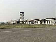
Gautam Buddha Airport is located 3 kilometers from the center and offers daily flights to Kathmandu. It is being upgraded to a regional international airport.
Transportation options around the city and into surrounding areas include bus, minibus, unmetered taxicab and cycle rickshaw. There is regular bus service to Lumbini and Butwal.
Immigration office
Border Crossing - Nepal has an open border where movement of Indian and Nepalese nationals concerned. There is a customs checkpoint for goods and third-country nationals.
Railway
The city is close to Nautanwa railway station.
Non-profit organizations
There are several NGOs are working in Siddharthanagar. Terai Development Forum is one working for healthy, social and economic status of female, children and poor community by using local resources and increasing capability for their services and justifiable accession to the resources. FSC Rupandehi (Farmers Service Committee, Rupandehi) is the only a Non-profit organisation working for Farmers Families Development in Rupandehi and also supporting to others district by developing Non-profit organisation. Actually, more than 75% of total population are depending on Agro occupation In Siddharthanagar municipality also. Samriddhi Foundation is one which is working in education and health sectors.
Education
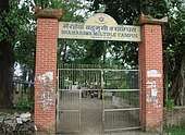
There are several higher education facilities in Siddharthanagar including Rupandehi Campus,[6][7] IAAS Paklihawa Campus, and Universal College of Medical Sciences
Media
Siddharthanagar has three FM radio stations:
- Rupandehi FM - 102 MHz, a community radio station
- Siddhartha FM - 98.8 MHz.
- Bhairahawa FM
All major Nepali Newspapers are circulated in Siddharthanagar, while several local ones including Gautam Buddha Sandes, Lumbini Khabar, Naribimba, and Siddhartha Post.
Culture
Hindus are in the majority, with a significant minority of Muslims and Buddhists associated with sites commemorating Gautama Buddha's life and relics. There is diversity in the culture as people from several part of country live here. Awadhi and Bhojpuri culture is native identity.
Cuisine
The local cuisine is influenced by the Awadhi cuisine.
Health

Siddharthanagar has a highly developed healthcare system with several famous hospitals including Bhim hospital(District Government Hospital), Universal College of Medical Science Hospital (UCMS Hospital) and Lumbini Eye Institute.
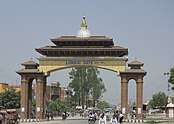
Places of interest
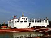
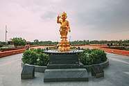
- Lumbini Garden around Buddha's birthplace with monasteries representing nations. It is approximately 22 km (14 mi) from Siddharthanagar.
- Devadaha, an archeological site 15 km (9.3 mi) northeast near Khairhani village. The site is associated with the Koliyas, tribe of Lord Buddha's mother and one of eight tribes receiving corporeal relics after his death at Kushinagar.
- Ramagrama stupa, 20 km (12 mi) east of Siddharthanagar and 4 km (2.5 mi) south of Parasi in Nawalparasi District. There are remains of stupa and monastery on banks of Jahari River near Kerwani village. The stupa mound is approximately 10 m (33 ft) high and 20 m (66 ft) in diameter. Some suggest this was the center of the Koliya kingdom.
- Kapilvastu was the kingdom of the Shakyas, Buddha's (paternal) royal family. The administrative center of modern Kapilvastu District at Taulihawa is 40 km (25 mi) west of Siddharthanagar or 18 km (11 mi) beyond Lumbini. Many archaeological sites are within 10 km (6.2 mi) of Taulihawa. Local roads are in good condition.
- Tribeni Ghat on the Narayani River (known as Gandak in India) is an auspicious site for bathing. It attracts hundred thousands of pilgrims on Maghe Sankranti (Hindi: Makar Sankranti), approximately 15 January.
- Valmiki Ashram near Tribeni Ghat, believed to be the place where Prince Siddhartha got down from his horse Kantaka and strode off on foot and into the jungles in his search for answers.
- Chitwan National Park east of the Narayani River, a preserve larger than 900 km2 protecting some 700 native animal species—including gaur, tiger, rhinoceros, gharial and crocodile—and flora native to the Terai-Duar savanna and grasslands.
- Meudihawa village which is situated on the southern part of Bhairahawa.[8]
See also
References
- "ब्रोसर २०१४". Siddharthanagar Municipality. Retrieved 18 June 2020.
- Pant, Shashwat (23 January 2020). "New names for old places reflect the changing times, but not everyone is happy". The Kathmandu Post. Retrieved 18 June 2020.
- . Retrieved 27 February 2016.
- . Department Of Hydrology and Meteorology Retrieved 26 September 2014.
- Nepal - City Population - Cities, Towns & Provinces - Tables & Maps
- "Home | Rupandehi Campus". www.rupandehicampus.edu.np. Retrieved 23 January 2019.
- "Rupandehi Campus granted QAA certificate". My Republica. Retrieved 23 January 2019.
- http://www.meudihawa.weebly.com
External links
| Wikivoyage has a travel guide for Bhairahawa. |
Headquarter: Siddharthanagar | ||||||
| Urban |
|  | ||||
| Rural municipality |
| |||||
List of municipalities and rural municipalities of Nepal | ||||||