Si Songkhram District
Si Songkhram (Thai: ศรีสงคราม, pronounced [sǐː sōŋ.kʰrāːm]) is a district (amphoe) in Nakhon Phanom Province in northeast Thailand.
Si Songkhram ศรีสงคราม | |
|---|---|
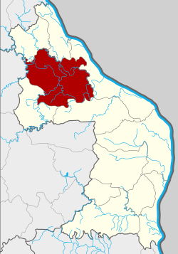 District location in Nakhon Phanom Province | |
| Coordinates: 17°37′38″N 104°15′2″E | |
| Country | Thailand |
| Province | Nakhon Phanom |
| Seat | Si Songkhram |
| Area | |
| • Total | 671.317 km2 (259.197 sq mi) |
| Population (2005) | |
| • Total | 65,952 |
| • Density | 98.2/km2 (254/sq mi) |
| Time zone | UTC+7 (ICT) |
| Postal code | 48150 |
| Geocode | 4808 |
Geography
Neighboring districts are (from the north clockwise): Na Thom, Ban Phaeng, Tha Uthen, Phon Sawan, and Na Wa of Nakhon Phanom Province, and Akat Amnuai of Sakon Nakhon Province.
The district is named after its main river, the Songkhram River.
History
The area was at first part of Tha Uthen District. On 1 April 1926, it was split off as the minor district (king amphoe) Akat Amnui (อากาศอำนวย), the present day Akat Amnui District in neighboring Sakon Nakhon was also originally controlled from Tha Uthen. The minor district consisted of the seven tambons: Na Wa, Ban Kha, Ban Siao, Sam Phong, Ban Waeng, Na Thom, and Ban Phaeng.[1] The minor district was renamed Si Songkhram in 1939,[2] and was upgraded to a full district on 10 March 1953.[3]
Administration
The district is divided into nine sub-districts (tambons), which are further subdivided into 106 villages (mubans). Si Songkhram itself has township (thesaban tambon) status and covers part of tambon Si Songkhram. There are a further nine tambon tambon administrative organization (TAO).
| No. | Name | Thai name | Villages | Pop. | |
|---|---|---|---|---|---|
| 1. | Si Songkhram | ศรีสงคราม | 10 | 8,120 | |
| 2. | Na Duea | นาเดื่อ | 11 | 6,889 | |
| 3. | Ban Ueang | บ้านเอื้อง | 15 | 10,738 | |
| 4. | Sam Phong | สามผง | 16 | 8,377 | |
| 5. | Tha Bo Songkhram | ท่าบ่อสงคราม | 7 | 4,875 | |
| 6. | Ban Kha | บ้านข่า | 13 | 6,959 | |
| 7. | Na Kham | นาคำ | 16 | 9,444 | |
| 8. | Phon Sawang | โพนสว่าง | 10 | 5,612 | |
| 9. | Hat Phaeng | หาดแพง | 8 | 4,938 |
References
- ประกาศ เรื่อง ตั้งกิ่งอำเภอในมณฑลอุดร (PDF). Royal Gazette (in Thai). 41 (0 ก): 268. January 24, 1926.
- พระราชกฤษฎีกาเปลี่ยนนามอำเภอ กิ่งอำเภอ และตำบลบางแห่ง พุทธศักราช ๒๔๘๒ (PDF). Royal Gazette (in Thai). 56 (0 ก): 354–364. April 17, 1939.
- พระราชกฤษฎีกาจัดตั้งอำเภอจักราช อำเภอสัตตหีบ อำเภอศรีสงคราม อำเภอชะอวด อำเภอหนองแซง อำเภอภาชี อำเภอเขาไชยสน อำเภอชุมพลบุรี อำเภอวาริชภูมิ อำเภอสบปราบ และอำเภอสุไหงโกลก พ.ศ. ๒๔๙๖ (PDF). Royal Gazette (in Thai). 70 (17 ก): 368–371. March 10, 1953.