Na Thom District
Na Thom (Thai: นาทม, pronounced [nāː tʰōm]) is a district (amphoe) of Nakhon Phanom Province, northeastern Thailand.
Na Thom นาทม | |
|---|---|
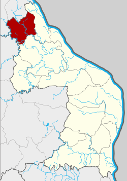 District location in Nakhon Phanom Province | |
| Coordinates: 17°47′7″N 104°5′26″E | |
| Country | Thailand |
| Province | Nakhon Phanom |
| Seat | Don Toei |
| Area | |
| • Total | 398.1 km2 (153.7 sq mi) |
| Population (2005) | |
| • Total | 21,930 |
| • Density | 55.1/km2 (143/sq mi) |
| Time zone | UTC+7 (ICT) |
| Postal code | 48140 |
| Geocode | 4811 |
Geography
Neighboring districts are (from the east clockwise): Ban Phaeng and Si Songkhram of Nakhon Phanom Province; Akat Amnuai of Sakon Nakhon Province; and Seka and Bueng Khong Long of Nong Khai Province.
History
The minor district (king amphoe) Na Thom was established on 1 April 1992, when three tambons were split off from Ban Phaeng District.[1] It was upgraded to a full district on 11 October 1997.[2]
Administration
The district is divided into three sub-districts (tambons), which are further subdivided into 35 villages (mubans). There are no municipal (thesabans), and three tambon administrative organizations (TAO).
| No. | Name | Thai name | Villages | Pop. | |
|---|---|---|---|---|---|
| 1. | Na Thom | นาทม | 15 | 8,310 | |
| 2. | Nong Son | หนองซน | 12 | 8,331 | |
| 3. | Don Toei | ดอนเตย | 8 | 5,289 |
References
- ประกาศกระทรวงมหาดไทย เรื่อง แบ่งเขตท้องที่อำเภอบ้านแพง จังหวัดนครพนม ตั้งเป็นกิ่งอำเภอนาทม (PDF). Royal Gazette (in Thai). 109 (53 ง special): 12. April 22, 1992.
- พระราชกฤษฎีกาตั้งอำเภอหนองปรือ อำเภอห้วยกระเจา อำเภอทรายทองวัฒนา อำเภอปางศิลาทอง อำเภอเนินสง่า อำเภอนาทม อำเภอพระพรหม อำเภอแม่วงก์ อำเภอสองแคว อำเภอบ้านใหม่ไชยพจน์ อำเภอไทยเจริญ อำเภอกาบัง อำเภอพยุห์ อำเภอเมืองจันทร์ อำเภอภูพาน อำเภอคลองหอยโข่ง อำเภอเขาฉกรรจ์ อำเภอนาวัง อำเภอพิบูลย์รักษ์ และอำเภอทุ่งศรีอุดม พ.ศ. ๒๕๔๐ (PDF). Royal Gazette (in Thai). 114 (50 ก): 24–27. September 26, 1997.
This article is issued from Wikipedia. The text is licensed under Creative Commons - Attribution - Sharealike. Additional terms may apply for the media files.