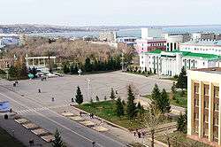
Kokshetau
Kokshetau (Kazakh: Көкшетау, romanized: Kókshetaý), formerly known as Kokchetav (Russian: Кокчетав, until 1993) is the administrative center of Aqmola Region, northern Kazakhstan. Population: 135,106 (2009 Census results);[2] 123,389 (1999 Census results).[2]
Kokshetau Kókshetaý | |
|---|---|
City | |
 | |
 Seal | |
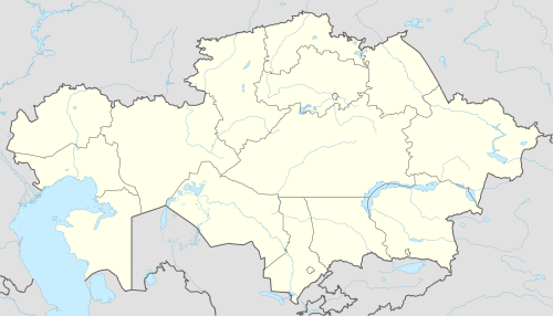 Kokshetau Location in Kazakhstan | |
| Coordinates: 53°17′N 69°23′E | |
| Country | Kazakhstan |
| Region | Aqmola |
| Founded | 1824 |
| City status | 1862 |
| Government | |
| • Akim (mayor) | Amangeldy Khalaudanovich Smailov |
| Area | |
| • Total | 400 km2 (200 sq mi) |
| Population (2013-07-01)[1] | |
| • Total | 145,161 people (2,019) |
| Time zone | UTC+6 (UTC +6) |
| Postal code | 020000 |
| Area code(s) | +7 7162 |
| Vehicle registration | C, 03 |
Geography
Kokshetau is some 300 kilometres (190 mi) north-west of the national capital of Nur-Sultan. The Kokshetau area is known for its two national parks, Burabay and Kokshetau. The city of Kokshetau is located on the shores of Lake Kopa.
The foremost attraction of Kokshetau area is the Burabay State National Natural Park, combining 14 beautiful lakes located among the picturesque mountains covered with dense coniferous forests. The most significant one among them in terms of size, beauty and tourists admire is Lake Borovoe. The lake is located 70 km from the town. The mild mountain climate, clean and fresh air and the presence of healing mud make the stay here not only pleasant, but also health-friendly and therapeutic.
History
Kokshetau was founded in 1824 by Russian military as an outpost. The name of the city is of Kazakh origin literally meaning "a smoky-blue mountain". In 1868 it became a district center of Omskaya gubernia in the Russian Empire. In 1944 Kokchetav became the administrative center of the newly created Kokchetavskaya Oblast. In 1997 Kokshetau Oblast region was liquidated. In 1999 due to an administrative changes in the structure of Aqmola and North Kazakhstan regions Kokshetau became the center of Aqmola Oblast.
In late 1930s as a result of the Polish operation of the NKVD - USSR citizens of Polish nationality, related national operations, also against Kazakh SSR Germans, since 1939 many residents of the Poland's kresy wschodnie were forcibly settled in this region, and Kokchetav became the center of the Polish community in Kazakhstan.[3]
Climate
Kokshetau lies in a cold semi-arid climate (Köppen climate classification BSk) zone with extreme continental influences. It has long, cold winters and hot summers. The average temperature in January is −15.3 °C (4.5 °F). In July the temperature averages 20.2 °C (68.4 °F). Yearly precipitation amounts to 313 mm (12.3 in).
| Climate data for Kokshetau | |||||||||||||
|---|---|---|---|---|---|---|---|---|---|---|---|---|---|
| Month | Jan | Feb | Mar | Apr | May | Jun | Jul | Aug | Sep | Oct | Nov | Dec | Year |
| Daily mean °C (°F) | −15.3 (4.5) |
−15.1 (4.8) |
−7.4 (18.7) |
4.0 (39.2) |
12.2 (54.0) |
18.4 (65.1) |
20.2 (68.4) |
16.8 (62.2) |
11.3 (52.3) |
2.5 (36.5) |
−6.1 (21.0) |
−11.8 (10.8) |
2.5 (36.5) |
| Average precipitation mm (inches) | 12.8 (0.50) |
11.3 (0.44) |
10.5 (0.41) |
17.9 (0.70) |
32.7 (1.29) |
40.2 (1.58) |
68.5 (2.70) |
43.6 (1.72) |
24.8 (0.98) |
22.8 (0.90) |
15.7 (0.62) |
11.7 (0.46) |
312.5 (12.3) |
| Average rainy days | 3.7 | 3.4 | 3.0 | 4.2 | 6.5 | 6.5 | 8.5 | 7.3 | 5.5 | 6.2 | 4.3 | 3.3 | 62.4 |
| Mean monthly sunshine hours | 89.0 | 127.0 | 196.0 | 227.0 | 277.0 | 306.0 | 313.0 | 250.0 | 190.0 | 118.0 | 88.0 | 75.0 | 2,256 |
| Source: NOAA (1961-1990)[4] | |||||||||||||
Industry
After the collapse of the Soviet Union in 1991 most plants and factories in the city stopped their production for ever. At that moment the city had a number of grain mills and some dairy production. A gold mine operates north of the city.
Transport
Air
Kokshetau is served by Kokshetau International Airport (IATA Airport Code: KOV). It is located 12.5 km (7.8 mi) north-east from the centre of city. It serves mostly domestic flights. SCAT Airlines fly to and from Almaty and Aktau as well as FlyArystan operates three weekly flights to Almaty.
Sister cities

References
- "Archived copy". Archived from the original on 2011-05-26. Retrieved 2009-10-22.CS1 maint: archived copy as title (link)
- "Население Республики Казахстан" (in Russian). Департамент социальной и демографической статистики. Retrieved 8 December 2013.
- Kate Brown, A Biography of No Place: From Ethnic Borderland to Soviet Heartland (Harvard University Press, 2004: ISBN 0-674-01168-6), pp. 173-74.
- "Kokshetay Climate Normals 1961-1990". National Oceanic and Atmospheric Administration. Retrieved January 10, 2013.
External links
| Wikimedia Commons has media related to Kokshetau. |
- www.akmo.kz

- 360° QTVR fullscreen panoramas of the Kokshetau
Capital: Kokshetau | ||
| Districts |  | |
| Major cities | ||
| Capital |  | |
|---|---|---|
| Other cities | ||
| Authority control |
|
|---|