Akmola Region
Akmola Region | |
|---|---|
Region | |
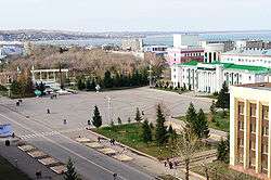 The center of Kokshetau | |
 Coat of arms | |
 Map of Kazakhstan, location of Akmola Region highlighted | |
| Coordinates: 52°0′N 69°0′E | |
| Country | |
| Capital | Kokshetau |
| Government | |
| • Akim | Ermek Marzhyqpaev |
| Area | |
| • Total | 146,219 km2 (56,455 sq mi) |
| Population (2017-06-01)[2] | |
| • Total | 715,000 |
| • Density | 4.9/km2 (13/sq mi) |
| Time zone | UTC+6 |
| • Summer (DST) | UTC+6 (not observed) |
| Postal codes | 020000 |
| Area codes | +7 (717) |
| ISO 3166 code | KZ-AKM |
| Vehicle registration | 03, C |
| Districts | 17 |
| Cities | 8 |
| Townships | 14 |
| Villages | 671 |
| Website | akmo |
Geography
Relief
The Akmola region occupies the Western edge of Kazakhstan between the Ulytau Mountains in the Southwest and the Kokshetau heights in the North. The land slopes from East to West and the central part of the region is crossed by the Ishim river valley, which runs steeply to the North close to the Western border of the region. The Akmola region can be divided into 3 parts: The North-Western plain, the South-Western plain with separate hills and the Eastern elevated part. The North-Western part, which is adjacent to the Ishim valley where it turns to the North, is a flat plateau divided by dry ravines and gullies. To the Ishima valley, the plateau ends in a ledge. In the South-Western part of the Akmola region, an elevated plain extends which is dotted with numerous flat-topped hills and in the depressions between the hills lay various shallow salt and fresh lakes. The East of the region, once mountainous, was levelled by the processes of destruction which preserved a complex of hills, ridges and hummocks with soft outlines in the slopes called hills. The relative heights of these hills are from 5-10m to 50-60m and less often, up to 80-100m. The shape and size of these hills vary depending on the composition of the composing rocks. The highest hills with rounded tops are usually composed of granite, the hills with more gentle slopes are soft-textured peaks-porphyry and peaked hills are usually composed of quartzite. Closed basins between the hills, ranging in size from several tens of meters to several tens of kilometers in diameter, are often occupied by lakes. The extreme North-Eastern part of the Akmola region lies within the West Siberian lowland.
Climate
The climate of the Akmola region is sharply continental and arid, with hot summers and cold winters and daily and annual temperature amplitudes which are very large. The region receives many days of sunlight and the amount of solar heat received by the earth in the summer is almost as great as in the tropics. Cloud cover is insignificant and annual precipitation decreases from North to South, with a maximum amount of coverage in June and a minimum in February. Snow cover is maintained for an average of 150 days. Winds in the Akmola region are quite strong.
Hydrography
The Akmola region is low in water. Rivers are shallow, non-navigable and fed by meltwater and often underground sources. In summer, rivers often dry up and their water becomes salty. The main rivers of Akmola region are the Ishim - a tributary of the Irtysh- and its tributaries: TERS-Akkan, Zhabay and Koluton. Many rivers end in drainless lakes. Dozens of lakes occupy the basins of the small-grasslands and the elevated plain of the Akmola region. The largest of them is the Tengiz salt lake, about 40 km wide near the border with the Karaganda region. Due to low-lying shores, the lake can change its shape in strong winds.
The soil and vegetation cover of the Akmola region is represented by steppes and semi-deserts. Depending on the terrain and underlying rocks, soil complexes and plant associations are extremely variegated and diverse. To the North of Ishim there are grass steppes, while in the south are chernozems with a large number of salt flats on the depressions and skeletal soils on the hills. Vegetation is drought-resistant and accommodates grasshoppers, tipchak and pine forests which are often found on hills. The Western third of the Akmola region extends along the river valley. Ishim, to the East to the city of Nur-Sultan, is occupied by grass steppes on dark chestnut soils. The blackness of the soil here is only 30-40%. To the East of the city of Nur-Sultan, the soil covers a significant role and in vegetation, sagebrush and tipchaks. In the southern part of the Akmola region, in the area of Lake Tengiz, an unclosed cover of sagebrush and tipchaks is spread on salt marshes.
History
In the nineteenth century, the tribes of the Middle Zhuz: Argyns (birth Kuandyk, Suyundik, Conjugally, Karauyl, Tarakty), Naiman (Baganaly, Baltali), Kerei (Cursory, Aksary) lived on the territory of Akmola region.
On October 14, 1939, by a decree of the Presidium of the Supreme Soviet of the USSR, the Akmola region was formed from parts of the Karaganda and North Kazakhstan regions. Its composition included from the Karaganda regionAkmola and the 4 districts of Akmola, Wisniewski, Novocherkassk and Arthritsi and from the North-Kazakhstan region,the town of Stepnyak and the 11 districts of Aryk-balyk, Atbasar, Tselinograd, Pavlodar, Kalinin, Makinsk, Molotov, Ruzaevskiy, Stalin, Shchuchinsk and Enbekshilderskiy. On October 16, 1939, the 16th district-Shortandinsky — was formed.
On March 15, 1944, the Aryk-balyk, Zerendinsky, Ruzaevsky, Shchuchinsky and Embekshelder districts were transferred to the new Kokchetav region.
On September 14, 1954, the city of Stepnyak was transferred from the Akmola region to the Kokchetav region.
On 22 October 1955, the areas of Baranowski and Kiminski were formed.
On July 30, 1957, the Molotovsky district was renamed as the Balkashinsky district.
On December 26, 1960, the Akmola region was abolished, and the territory of the region became part of the Virgin territory.
On March 20, 1961, the city of Akmolinsk was renamed Tselinograd.
On April 24, 1961, the Tselinograd region was established with the region's being in Tselinograd. The region included the areas of Atbasar, Baltasinsky, Baranowski, Wisniewski, Esil, Kalinin, Kiminski, the Kurgaldzhino, Makinsk, Novocherkassk, Stalin, Tselinograd, Shortandy and Arthritsi. On November 18, the Stalinsky district was renamed the Leninsky district.
On January 2, 1963, a new administrative division was introduced. The Tselinograd region was divided into 10 rural district: Alekseyevsky (former Leninsky), Astrakhan (former Novocherkassk), Atbasar, Balkashinsky, Derzhavinsky, Ermentau (former Yerkenshilik), Yesilsky, Zhaksynsky, Kurgaldzhinsky, Tselinograd) and 1 industrial district (Zholymbetsky).
On December 31, 1964, the Vishnevsky and Makinsky districts were restored and the Zholymbet industrial district was abolished.
On October 19, 1965, the Tselinny Krai was abolished and the region again directly became a part of the Kazakh SSR.
On January 31, 1966, the Shortandinsky district was restored and on May 28, the Zhanadaly district was established.
On November 23, 1970, the Derzhavinsky, Yesilsky, Zhaksynsky and Zhanadalysky districts were transferred to the new Turgay region. On December 4, the Krasnoznamensky district was formed.
On December 25, 1973, the Marinovsky and Seletinsky districts were formed.
On February 15, 1977, the Tengiz district was established.
By the decree of the Presidium of the Supreme Soviet of the Kazakh SSR of July 18, 1985, the Tengiz district was transferred to the Karaganda region which is now part of the Nurinsky district of the Karaganda region.
On July 9, 1988, the Marinovsky district was abolished and its territory was transferred to the Makinsky district.
In 1992, Tselinograd was renamed to Akmola. From from 1998 to 2019 it was renamed Astana, from 2019 Nur-Sultan and the region — to Akmola.
On February 28, 1997, the Seletinsky district was abolished by the Decree of the President of the Republic of Kazakhstan No. 3370 of 28.02.1997 and the territory of the abolished Seletinsky district was transferred to the Yerementau district. On April 22, the Derzhavinsky, Zhaksyn, Zhanadaly, Yessil and Kiyminsky districts were transferred from the abolished Turgay region to Akmola. On 23 July,the Gandlevsky (territory transferred to Zharkain district) and Kiminski areas were abolished. On November 14, the Alekseyevsky district was renamed Akkol, Balkashinsky — Sandyktau, Vishnevsky - Arshalynsky, Krasnoznamensky - Egindykolsky, Makinsky-Bulandynsky, Derzhavinsky-Zharkainsky.
On April 10, 1999, three southern districts of the North Kazakhstan region (Zerendinsky, shchuchinsky, Enbekshildersky, which were part of the abolished Kokchetav region until 1997) with the cities of Kokshetau, Shchuchinsk and Stepnyak (also part of the abolished Kokchetav region until 1997) were transferred to the Akmola region. At the same time, the administrative centre of the Akmola region was moved from the capital of the country Astana to the city of Kokshetau.
Administrative division
The Akmola region consists of 17 districts and 2 cities of regional significance:
1. Akkol district
2. Arshalynsky district
3. Astrakhan region
4. Atbasar district
5. Bulandynsky district
6. Burabaysky district
7. Egindykolsky district
8. Birzhan-Sal district
9. Ereymentau district
10. Esil district
11. Zhaksynsky district
12. Zharkainsky district
13. Zerenda district
14. Korgalzhyn district
15. Sandyktau district
16. Tselinograd district
17. Shortandy district
18. City of Kokshetau
19. City of Stepnogorsk
Districts include:
1. 8 cities of district subordination: Akkol, Atbasar, Derzhavinsk, Esil, Yerementau, Makinsk, Stepnyak, Shchuchinsk
2. 15 villages
3. 245 rural districts

Akmola Region (Kazakh: Ақмола облысы, romanized: Aqmola oblysy; Russian: Акмолинская область, tr. Akmolinskaya oblast') is a centrally located region of Kazakhstan. Its capital is Kokshetau. The national capital, Nur-Sultan, is enclosed by the region, but is politically separate from Akmola Region. The region's population is 715,000; Kokshetau's is 157,000. The area is 146,200 square kilometers. It and Karaganda Region are Kazakhstan's only two regions which don't touch the country's outer borders. Akmola Region borders North Kazakhstan Region in the north, Pavlodar Region in the east, Karagandy Region in the south, and Kostanay Region in the west. Some gold and coal mining occur in the area.
Investment potential
Akmola region is located in the northern part of Kazakhstan.The territory of the region is 146.2 thousand square kilometers (5.4% of the territory of the state).The average population density in the region is 5.1 people per 1 square km.The population of the region is 738.6 thousand people (as of January 1, 2019). The region consists of 2 cities of regional significance and 17 districts of regional significance, 8 small towns.
Akmola region is an agricultural and industrial region of Kazakhstan. The tourism and alternative energy industries are also gaining momentum.
Advantages of the region:
Developed transport and transit potential.
The region has an international airport Kokshetau, six-lane 205-kilometer highway Nur-sultan-Shuchinsk.Funding for improving the condition of local roads is increased annually. The region has a developed railway network. 4 branches of Railways pass through the city of Kokshetau. The region has the highest density of railways in the country - 10.66 km per 1000 square km of territory (average in the Republic of Kazakhstan - 5.53).Акмолинская область
Access to sales markets
The capital of the state, Nur–Sultan, is located on the territory of the region.The region borders with 4 regions-Kostanay, North Kazakhstan, Pavlodar and Karaganda regions. Nearby regions of the Russian Federation: Omsk, Novosibirsk, Kurgan, Chelyabinsk, Tyumen, and Sverdlovsk regions that can be reached by road within one day.
Rich natural resources
The region is rich in minerals and occupies one of the leading places in the mineral resource complex of the Republic of Kazakhstan.The region contains unique reserves of gold (Akkol, Astrakhan, Birzhan Sal, Burabay, Bulandy, Zerenda, Shortandy districts and Stepnogorsk), uranium (Akkol, Birzhan Sal, Zerenda, Sandyktau districts), molybdenum (Birzhan Sal, Yerementau, Sandyktau districts), technical diamonds, kaolin, muscovite and dolomite (Zerenda district), iron ore (Akkol, Birzhan Sal, Zharkain districts), coal (Yerementau, Akkol districts), common minerals, mineral waters.
The total land fund is 14.6 million ha, including agricultural land-10.8 million ha: arable land-6 million ha, pastures-4.4 million ha.The area of the forest Fund is 522.7 thousand ha, and the water Fund is 201.2 thousand ha.Акмолинская область
Agricultural industry
Akmola region accounts for more than 25% of grain, 7% of milk, 8% of meat and 16% of eggs produced in the Republic.The region's share in the country's gross agricultural production is about 10%.
Akmola region in the Republic is the largest harvesting wedge in the country - 4.8 million ha, including cereals and legumes-4.4 million ha.
The average annual production of grain is 5.0 million tons, the average annual export of grain is 2 million tons, over the past 3 years, and the share of crop production has averaged 70%.
In all regions of the region there are opportunities for the development of animal husbandry.The most promising areas for attracting investment are Arshaly, Atbasar, Burabay, Zerenda, Yerementau and Tselinograd districts.
Major projects:
- the first stage of the broiler poultry farm with a capacity of 50 thousand tons of poultry meat per year, the launch of the second stage is planned for 2020.The total investment amount for the project is more than 53 billion tenge(«Makinskaya poultry farm»LLP, Bulandy district);
- reconstruction of a meat processing plant with a capacity of 5 tons per day. The investment amount is 4.5 billion tenge («Kazbeefprocessing» LLP, Burabay district).
Industry
In the industrial sector, the region specializes in the extraction of gold-containing ores, uranium, mechanical engineering and chemical industry. Akmola region accounts for 100% of railway bearings produced in the country, 36.3% of trucks, 30.2% of unprocessed gold, 12.1% of processed milk and 9% of flour. In the structure of industrial production, the main share is taken by the manufacturing industry - 80.4%, where products worth 533.1 billion tenge were produced.The manufacturing industry of the region is represented by food production, light and chemical industry, production of rubber and plastic products, production of other non-metallic mineral products, non-ferrous metallurgy and mechanical engineering.
Backbone enterprises of the region are a factory for the production of alcoholic and non-alcoholic drinks «Kokshetauminvody»JSC, gold factory, «AltyntauKokshetau»JSC, «MMC «Kazakhaltyn» JSC, «KazakhaltynTechnology"LLP, company for production and processing of agricultural products «Agrofirm TNK» LLP, bearing plant JSC «EBC-Stepnogorsk» JSC.
Major projects:
- cement plant with a capacity of 2 million tons per year.The investment amount is 63.1 billion tenge(«Kokshe-Cement» LLP, Birzhan Sal district).
- gold-extracting factories at Aksu, Bestobe, and Zholymbet mines. The total investment amount is 30.6 billion tenge(«Kazakhaltyntechnology» LLP, Stepnogorsk).
Culture
There are 694 cultural objects of different variety in the Akmola region, 663 of them state-owned,
31 other varieties include:
- 276 clubs (including 256 public and 20 private);
- 378 libraries (including 370 state and 8 departmental libraries);
- 11 museums;
- 2 theaters;
- 21 state archives;
- the regional Philharmonic society;
- the center for the protection and use of historical and cultural heritage;
- the regional center of folk art and cultural leisure activities;
- 3 private cinemas.
There are 2,513 club varieties in the region.
In the region, there are 81 people with a national rank, and 18 with the "Exemplary" rank.
There are 99 teams: choreographic — 31, quire — 18, folk — 18, vocal groups — 14, amateur theatres — 4; family ensembles, circus, ensembles of Russian folk instruments, ensembles of song and dance, ensemble of Kazakh folk instruments — 2; vocal instrumental ensemble, photography, orchestra of Russian folk instruments, poetic — 1.Акмолинская область
Education
Pre-school education and training
There are 614 pre-school education organizations in the Akmola region, including 240 kindergartens and 374 pre-school mini centers which serve 37,955 students.
General secondary education
There are 579 schools in the region, including 560 state day schools, 10 evening schools, 5 special correctional schools, 2 non-departmental, 1 non-state and 1-Nazarbayev Intellectual school which serve 124,228 students.
Technical and professional, post-secondary education
The region is organized through a network represented by 33 institutions with a total population of 21,600 people. Out of 33 colleges, 26 are public and 7 are private. Training is conducted in 94 professions and 139 qualifications in subjects such as agriculture and forestry, construction and utilities, pedagogy, medicine, mining, service, art and culture, energy, engineering technology, transport operation.
Religion
According to official data as of January 1, 2020, in the Akmola regionthere are 191 registered religious associations:
90 Islamic
45 Orthodox
11 Catholic
43 Protestant
1 Baha'i
1 society of Krishna Consciousness of Akmola region
10 unregistered religious associations of Evangelical Christians-Baptists
Tourism
The recreation and tourism industry is one of the priority sectors of Akmola's economy. The tourist industrycomprises more than 700 tourism enterprises which includes 375 accommodation facilities, 45 health resorts, 266 roadside service entities, 68 travel agencies and the state national parks of "Kokshetau", "Burabai", "buiratau", Korgalzhyn state nature reserve,"Burabai Damu" LLP.
The cultural and historical segment of the cluster is represented by 900 monuments, most of which are under state protection and are used for providing sightseeing programs.
There are about 80 tourist routes in the region that are successfully operated by tour operators and included in the state register of tourist routes. Among them, 10 tour operators have developed and use tourist routes to the historical and sacred places of Kokshetau, Burabay, Zerendinsky, Korgalzhyn and yerementau districts and Birzhan Sal district of Akmola region. Among them are 8 approved routes to sacred places.
According to statistics, in the first quarter of 2019, the number of accommodation units amounted to 375 units with a total capacity of the Fund — 5,159 rooms with a one-time capacity of 13,327 beds.
There are 9 certified accommodation facilities in the region.
As part of Kazakhstan's digitalization process, there is a 3-language Internet resource (www.visitaqmola.kz) and the mobile app "Visit Aqmola", which include a QR code scanning of popular places in the region which are synchronized with the electronic information kiosks available at the international airport "Nursultan Nazarbayev", in the village of Borovoe-based on the visit center of "Burabay Damu" LLP and installed in the building of "Nurly Zhol" railway station in Nur-Sultan.
To ensure the availability of the tourist product in the region, the official tourist card "Burabay PASS" (travel guide, smart card and Beeline SIM card) has been launched. There are more than 600 registered sales on the market.
Sport
There are 2,408 sporting facilities for physical activities and sports in the Akmola region, 1,690 of them located in rural areas. Compared to last year, 53 new facilities have been created.
Around 2,108 people work in the field of physical activity and sports, including 1,177 people in the villages. They include 1,117 secondary school teachers, 160 secondary special and higher educational institutions teachers, and 414 coaches. 171 full-time sporting instructors work in rural districts and businesses, 160 of them in rural areas, which is 68.7% of the provision of rural districts.
Health
568 healthcare facilities provide medical assistance to the population: 23 (4%) hospitals, ambulance stations, blood centers, 537 organizations (94.5%) that provide outpatient care: (3 city clinics, 1 primary health care center, 2 district clinics, 1 AIDS Center, 100 outpatient clinics, 44 paramedic — midwifery centers, 386 medical centers).
There are also 6 other medical organizations (1.6%).
Domestic policy
In the Akmola region, there are 6 regional branches of political parties "Nur Otan", "CPPK"," "Auyl"," "AK Zhol", "Birlik", “NSDP" and 2 socio-political associations (Republican Slavic movement "LAD", and the Akmola regional branch of the Patriotic movement"Zheltoksan akikaty").
There are 3 public Cossack organizations on the territory of the Akmola region: the Akmola branch of the Union of Cossacks of the Steppe region, the Akmola Department of Siberian Cossacks, and the Akmola Cossack society.
718 non – governmental organizations are registered in the Akmola region, 514 of them active.
44 ethno-cultural associations operate in the Akmola region, including ethno-cultural associations.
There are 18 ethnic groups, as well as Slavic and Cossack associations (Russian - 3, Slavic - 5, Cossack-11, Polish-7, German-3, Armenian-3, Azerbaijani-3, Jewish-4, Chechen-Ingush-2, Uzbek-2, Ukrainian-1, Korean-2, Tatar-Bashkir-2, Turkish-1, Chuvash-1, Kurds-1, Uighur-1, Tajik-1).
Ethnic and cultural associations were established in 12 districts and cities of Kokshetau and Stepnogorsk. 18 associations were registered in the districts of the region, 33 in Kokshetau, and 2 in Stepnogorsk.
There are also 4 Houses of Friendship, and the Sunday school of language learning "Shanyrak" is located at the Akmola Assembly of the People of Kazakhstan, where 9 languages are studied.
There are 37 mediation offices in the Akmola region: 14 mediation offices are located at the local executive institutions, 22in the court, 1in the Akmola Assembly of the People of Kazakhstan (House of Friendship of Kokshetau).
Language development
The share of the adult population that speaks the state language in 2019 is 76%, which is 6% more than in 2017.
The share of the adult population that speak the Russian language in 2019 is 84.3%.
9% of the population of the region speak English.
5.5% speak three languages.
The share of ethnic groups with ethnic and cultural associations covered by methodological assistance for the study of Kazakh and native languages in 2019 is 27%.
There are 614 pre-school institutions in the Akmola region with around 37,675 children, of which 23,835 (63.3%) are brought up in the Kazakh language.
There are 560 general education schools in the region, including 159 where Kazakh language is used, 217 - mixed language, and 184 - Russian. The total number of students is around 121,521, including 58,393 (48%) students in Kazakh classes. 48% of children are taught in Kazakh classes, 1% than in 2015.
Today, there are 33 colleges in the region(2 teach in Kazakh, 26 in mixed languages, and 5 in Russian). These colleges have 21,351 students, 29.1% study in Kazakh groups.
To date, there are 20 language learning centers in the region (17 district, 2 city and regional centers). 18 centers teach Kazakh and English languages. In the 2017-2018 academic year, 5,320 students studied the state and English languages, including 4,761 studying the state language.
Youth policy
Around 148,996 young people live in the Akmola region, which is 20.2% of the total population of the region.
According to the Statistics Committee of Kazakhstan, the youth unemployment rate for the 4th quarter of 2019 was 3.1%, which is 0.8% lower than the national level.
As of January 1, 2019, the share of youth that are non-students, non-working and not in training was 5.9%, which is 1.1% lower than the national level.
Within the framework of the "Embek" program for the development of productive employment and mass entrepreneurship for 2017-2021, since the beginning of 2020, 2,059 youth representatives, including 1,167 from villages, have become participants. 82 people are involved in social jobs, and 179 people were sent to youth practice. Overall, employment agencies have found employment for 1,251 people since the beginning of 2020.
In order to create conditions for the employment of the population, and to support the inflow of human resources to rural areas in the region, the program "With a Diploma in the Village"is being implemented.
As of May 1, 2019, 211 people have received allowances in the amount of 372.9 million tenge, including specialists: education — 169 people; health — 25 people; social security — 1; culture — 2; sports — 7; agriculture – 7.
Budget loans were granted to 502 people in the amount of 374.5 million tenge, including education specialists — 72 people, 21 – health, 5 – culture, 4 — agriculture.
There are 20 councils for the implementation of state youth policy in the region (1 regional, 19 — district and city), headed by Mayors (regional, district and cities).
There are 24 active youth associations in the region. In order to support youth organizations and attract them to participate in social programs and projects, the office for youth policy annually provides funds for the implementation of the state social order.
To support young people from the socially vulnerable category, to encourage them to receive high-quality professional education in the region, the region's Mayor has established personal scholarships. In the 2018-2019 academic year, the number of participants reached 275. In 2019-20, 102.0 million tenge was allocated from the regional budget for the award of scholarships.
Agricultural industry
In 2020, spring sowing is planned on an area of 4.9 million hectares, including 4.4 million hectares for grains and legumes.
It is planned to plant oilseeds on an area of 254.0 thousand hectares, plant potatoes on16.1 thousand hectares, and vegetables on 3.4 thousand hectares.
Spring sowing of forage crops is planned on an area of 181.0 thousand hectares.
More than 16.1 thousand units of grain drills and 1,222 units of high-performance sowing complexes will be used in the sowing campaign in 2020. 65% of the grain wedge is planned to be sown in 2020, which will bring the area of sowing by moisture-saving technologies to 3.3 million hectares.
According to statistics, the total number of cattle in all categories of farms in the region as of April 1, 2020 is 502.1 thousand heads (103.0% compared to the same period in 2019), including 221.7 thousand cows (102.4%).
The number of horses is around 201.6 thousand heads (106.4%), poultry — 7589.3 thousand heads (101.5%).
The number of sheep and goats is around 632.2 thousand heads (101.5%), pigs 125.0 thousand heads (96.4%).
Archaeology
The Neolithic Atbasar culture was named after the site of the first excavations near the city of Atbasar in the Atbasar district[25].
A burial ground of the Andronovo culture was found near the village of Alekseyevka (Zerendinsky district). Reconstruction of the appearance of the Andronovo man using a skull found in this burial ground was carried out by M. M. Gerasimov.
Mayors
Brown, Andrey Georgievich (1992-1997)
Karibzhanov, Zhanybek Salimovich (July–December 1997).
Hartman, Vladimir Karlovich (December 1997-September 1998)
Kulagin, Sergey Vitalievich (September 1998-March 2004)
Esenbayev, Mazhit Tuleubekovich (March 2004-January 2008)
Rau, albert Pavlovich (January 2008-March 2010)
Dyachenko, Sergey Alexandrovich (March 2010-January 2012)
Kozhamzharov, Kairat Perneshovich (January 2012-January 2013)
Aitmukhametov, Kosman Kairtayevich (January 2013-May 2014)
Kulagin, Sergey Vitalievich (May 2014-March 2017)
Murzalin, Malik Kenesbaevich (March 2017-March 2019) [27]
Marzhikpayev, Ermek Boranbayevich from March 19, 2019
Notes
1. Population of the Republic of Kazakhstan by gender in the context of regions, cities, districts and district centers and villages at the beginning of 2019. The Committee on Statistics of the Ministry of the National Economy of the Republic of Kazakhstan. Accessed 2 August 2019.
2. Population of the Republic of Kazakhstan by individual ethnic groups 2019
3. The Vostrov V. V., Mukanov M. S. Tribal structure and resettlement of Kazakhs [Text]: (end of XIX - the beginning XX).- Alma-ATA "publishing house" Science "of the Kazakh SSR", 1968. - 255 p.
4. State archive of the Akmola region. Guide
5. Akmola region. History of the administrative division
6. Division of Kazakhstan
7. Population at the beginning of the yearby regions of the Republic of Kazakhstan, 2003-2012
8. Within the modern borders of the Akmola region, including part of the former Kokchetav region and excluding the city of Astana
9. All-Union population census of 1989. National composition of the population by regions of the Kazakh SSR
10. The population census of 1999. National composition of the population by regions of Kazakhstan
11. The 2009 census. National composition of the population by regions of Kazakhstan
12. Population of the Akmola region by individual ethnic groups at the beginning of 2019
13. Аt the time of the 2009 census the district was called Shchuchinsky district
14. former Alekseyevsky district
15. former Vishnevsky district
16. former district of Makinsk
17. former shchuchinsky district
18. former krasnoznamenskiy district
19. former Enbekshilder district
20. former Derzhavinsky district
21. former Balkashinsky district
22. Official information portal of the Mayor's Office of the Akmola region | Education. aqmola.gov.kz.
23. Official information portal of the Mayor's Office of the Akmola region | Education
24. Information about religion in the Akmola region as of January 1, 2016
25. Atbasar culture
26. Salnikov K. V. Ancient monuments of the history of the Urals
27. About appointment of Murzalin M. K. as Mayor of the Akmola region — Official website of the President of the Republic of Kazakhstan
28. Yermek Marzhikpayev was appointed Mayor of the Akmola region
Literature
· Akmola region // Kazakhstan. National Encyclopedia. - Almaty: Kazakh encyclopedias, 2004. - T. I. - ISBN 9965-9389-9-7
· Aitzhan Nurgalieva. Toponymic legends of the Akmola region.
· Information about changes in the administrative division of the Akmola region (1846-2009).
Demographics
Ethnic Kazakhs account for 53.4% of the population in the 2017 census, compared to 33.7% for Russians.[3]

The share of the European population by districts and cities of regional and republican subordination Kazakhstan in 2016
> 70٪
60.0 – 69.9 %
50.0 - 59.9 %
40.0 - 49.9 %
30.0 - 39.9 %
20.0 - 29.9 %
10.0 - 19.9 %
0.0 - 9.9 %
|
Notable residents
- David Rigert, weightlifter, Olympic champion, 5x world champion (light-heavyweight and heavyweight), 68 world records.
External links
| Wikimedia Commons has media related to Aqmola Province. |
References
- "Official site - General Information". Archived from the original on 2008-01-19. Retrieved 2008-01-14.
- Agency of statistics of the Republic of Kazakhstan: Численность населения Республики Казахстан по областям с начала 2013 года до 1 февраля 2013 года (russisch; Excel-Datei; 55 kB).
- ru:Акмолинская область
Places adjacent to Akmola Region | |
|---|---|
Capital: Kokshetau | ||
| Districts |  | |
| Major cities | ||
| Regions |  | |
|---|---|---|
| Special status cities | ||
| Authority control |
|---|