Shire of Stanthorpe
The Shire of Stanthorpe was a local government area of Queensland, Australia on the Queensland-New South Wales border. It was on the Great Dividing Range and was part of the Granite Belt. Its main industries included fruit and vegetable growing, wineries and tourism, and sheep and cattle grazing.
| Shire of Stanthorpe Queensland | |||||||||||||||
|---|---|---|---|---|---|---|---|---|---|---|---|---|---|---|---|
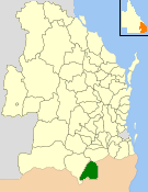 Location within Queensland | |||||||||||||||
| Population | 9,968 (2006 census)[1] | ||||||||||||||
| • Density | 3.69514/km2 (9.5704/sq mi) | ||||||||||||||
| Established | 1879 | ||||||||||||||
| Area | 2,697.6 km2 (1,041.5 sq mi) | ||||||||||||||
| Council seat | Stanthorpe | ||||||||||||||
| Region | Darling Downs | ||||||||||||||
| |||||||||||||||
The Shire, administered from the town of Stanthorpe, covered an area of 2,697.6 square kilometres (1,041.5 sq mi), and existed from 1879 until 2008, when it amalgamated with the Shire of Warwick to become the Southern Downs Region. Its final mayor was Glen Rogers.
History
On 11 November 1879, the Stanthorpe Division was created as one of 74 divisions within Queensland under the Divisional Boards Act 1879 with a population of 1339.[2]
On 25 June 1880, Ballandean Division (to the south) was abolished and absorbed into Stanthorpe Division.[3]
With the passage of the Local Authorities Act 1902, Stanthorpe Division became the Shire of Stanthorpe on 31 March 1903.
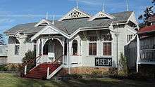
In 1914, the Stanthorpe Shire Council constructed council chambers.[4]
On 15 March 2008, under the Local Government (Reform Implementation) Act 2007 passed by the Parliament of Queensland on 10 August 2007, the Shire of Stanthorpe merged with the Shire of Warwick to form the Southern Downs Region.[5] At the time of its closure it had eight councillors plus an elected mayor.
Towns and localities
The Shire of Stanthorpe included the following settlements:
- Stanthorpe
- Amiens
- Applethorpe
- Ballandean
- Cottonvale*
- Dalcouth
- Diamondvale
- Eukey
- Glen Aplin
- Greenlands
- Kyoomba
- Lyra
- Messines
- Mingoola
- Passchendale
- Pikedale
- Pikes Creek
- Pozieres
- Severnlea
- Somme
- The Summit
- Thorndale
- Wallangarra
- Wyberba
* - acquired its name from one Private E Cotton a local who enlisted in the Australian Air Force
Chairmen
- 1927: Johnston Smyth
Population

| Year | Population |
|---|---|
| 1933 | 6.934 |
| 1947 | 7,419 |
| 1954 | 8,335 |
| 1961 | 8,514 |
| 1966 | 8,503 |
| 1971 | 8,189 |
| 1976 | 8,709 |
| 1981 | 8,576 |
| 1986 | 9,143 |
| 1991 | 9,556 |
| 1996 | 9,596 |
| 2001 | 9,860 |
| 2006 | 9,968 |
References
- Australian Bureau of Statistics (25 October 2007). "Stanthorpe (S) (Local Government Area)". 2006 Census QuickStats. Retrieved 18 September 2009.
- "Proclamation [Stanthorpe Division]". Queensland Government Gazette. 11 November 1879. p. 25:994.
- "Proclamation [Ballandean & Stanthorpe Divisions]". Queensland Government Gazette. 25 June 1880. p. 26:1512.
- Stanthorpe Heritage Museum (brochure). Stanthorpe & District Historical Society.
- "Agency ID11055, Southern Downs Regional Council". Queensland State Archives. Retrieved 21 September 2013.