Shire of Gayndah
The Shire of Gayndah was a local government area located in the northern catchment of the Burnett River, Queensland, Australia. The shire covered an area of 2,709.3 square kilometres (1,046.1 sq mi), and existed as a local government area from 1866 until 2008, when it amalgamated with several other shires to form the North Burnett Region.
| Shire of Gayndah Queensland | |||||||||||||||
|---|---|---|---|---|---|---|---|---|---|---|---|---|---|---|---|
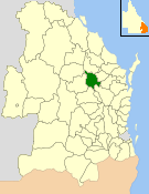 Location within Queensland | |||||||||||||||
| Population | 2,911 (2006 census)[1] | ||||||||||||||
| • Density | 1.07445/km2 (2.7828/sq mi) | ||||||||||||||
| Established | 1866 | ||||||||||||||
| Area | 2,709.3 km2 (1,046.1 sq mi) | ||||||||||||||
| Council seat | Gayndah | ||||||||||||||
| Region | Wide Bay–Burnett | ||||||||||||||
 | |||||||||||||||
| Website | Shire of Gayndah | ||||||||||||||
| |||||||||||||||
Major activities in the shire included citrus production, beef and timber.
History
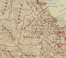
The first local government in the area was the Borough of Gayndah, serving the town of Gayndah, which was created on 28 November 1866 under the Municipal Corporations Act 1864. Under the Divisional Boards Act 1879, the Rawbelle Division was created on 11 November 1879 to serve the surrounding rural area with a population of 755.[2][3] The headquarters of the Rawbelle Division was in the town of Gayndah and the first meeting of the divisional board was held on 29 March 1880 and the first elected chairman was Berkeley Moreton, who would later inherit the title Earl of Ducie.[4][5]
On 31 March 1903, following the enactment of the Local Authorities Act 1902, the Borough of Gayndah became the Town of Gayndah and Rawbelle Division became Shire of Rawbelle.[3][6]
The Shire of Rawbelle was renamed Shire of Gayndah on 17 March 1923,[7] and on 24 May 1924 the Town of Gayndah was amalgamated into the Shire of Gayndah.[6][8][9]
On 15 March 2008, under the Local Government (Reform Implementation) Act 2007 passed by the Parliament of Queensland on 10 August 2007, the Shire of Gayndah merged with the Shires of Eidsvold, Biggenden, Monto, Mundubbera and Perry to form the North Burnett Region.[8][10]
Chairmen
- 1880 Berkeley Moreton, 4th Earl of Ducie [4]
- 1917: H. E. M. Leggett [11]
- 1927: H. E. M. Leggett [12]
H. E. M. Leggett was chairman of the shire for 25 years.[13]
Towns and localities
The Shire of Gayndah included the following settlements:
Population
| Year | Population |
|---|---|
| 1879 | 755 |
| 1933 | 3,760 |
| 1947 | 3,407 |
| 1954 | 3,352 |
| 1961 | 3,400 |
| 1966 | 3,182 |
| 1971 | 3,107 |
| 1976 | 2,814 |
| 1981 | 2,859 |
| 1986 | 2,887 |
| 1991 | 2,856 |
| 1996 | 2,916 |
| 2001 | 2,894 |
| 2006 | 2,911 |
References
- Australian Bureau of Statistics (25 October 2007). "Gayndah (S) (Local Government Area)". 2006 Census QuickStats. Retrieved 18 March 2008.
- "Proclamation [Rawbelle Division]". Queensland Government Gazette. 11 November 1879. p. 25:1003.
- "Agency ID1683, Rawbelle Divisional Board". Queensland State Archives. Retrieved 10 September 2013.
- "THE CENTRAL BURNETT". The Brisbane Courier. National Library of Australia. 13 April 1923. p. 7. Retrieved 3 October 2013.
- "EARL OF DUCIE". The Brisbane Courier. National Library of Australia. 31 October 1921. p. 7. Retrieved 3 October 2013.
- "Agency ID1684, Rawbelle Shire Council". Queensland State Archives. Retrieved 10 September 2013.
- "Order in Council". Queensland Government Gazette. 17 March 1923. p. 120:803.
- "Agency ID891, Gayndah Shire Council". Queensland State Archives. Retrieved 10 September 2013.
- "Agency ID892, Gayndah Town Council". Queensland State Archives. Retrieved 10 September 2013.
- Burnett Regional Council "Agency IDNorth Burnett Regional Council, 23 September 2013" Check
|url=value (help). Queensland State Archives. - Consolidated Index to Queensland Government Gazette 1859-1919. Queensland Family History Society. 2004. ISBN 1-876613-79-3.
- Pugh, Theophilus Parsons (1927). Pugh's Almanac for 1927. Retrieved 13 June 2014.
- "OBITUARY". Maryborough Chronicle. Qld.: National Library of Australia. 22 August 1949. p. 4. Retrieved 17 June 2014.