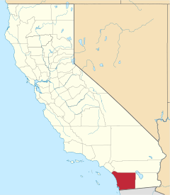
Santee, California
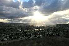
Santee is a suburban city in San Diego County, California, with a population of 53,413 at the 2010 census. Although it is a part of the East County region, Santee is located just 18 miles (29 km) from the Pacific Ocean. The city is connected to the coastline by State Route 52, a six-lane freeway that runs from Interstate 5 in La Jolla to State Route 67 in El Cajon. The city is bisected by the San Diego River, a linear greenbelt that includes parks, trails and more than 1,100 acres (450 ha) of natural riparian habitat.
Santee, California | |
|---|---|
City | |
 Seal | |
| Motto(s): Sustainable Santee[1] | |
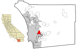 Location within San Diego County | |
 Santee Location in the United States  Santee Santee (California)  Santee Santee (San Diego County, California) | |
| Coordinates: 32°52′11″N 116°58′16″W | |
| Country | |
| State | |
| County | San Diego |
| Incorporated | December 1, 1980[2] |
| Area | |
| • Total | 16.53 sq mi (42.82 km2) |
| • Land | 16.24 sq mi (42.06 km2) |
| • Water | 0.29 sq mi (0.76 km2) 1.77% |
| Elevation | 351 ft (107 m) |
| Population | |
| • Total | 53,413 |
| • Estimate (2019)[6] | 58,081 |
| • Density | 3,578.39/sq mi (1,381.67/km2) |
| Time zone | UTC-8 (PST) |
| • Summer (DST) | UTC-7 (PDT) |
| ZIP codes | 92071-92072 |
| Area code(s) | 619 |
| FIPS code | 06-70224 |
| GNIS feature ID | 1656619 |
| Website | www |
History
The region was the homeland of the Kumeyaay people. These original residents established the village of Sinyeweche on the banks of the San Diego River in the present day Santee area.[7]
The city is named after Milton Santee, the second husband of Jennie Blodgett, whose first husband was George A. Cowles, a pioneer rancher and businessperson in the San Diego County area.[8]
Community profile
In 2010, the city was populated by 19,272 households, of which 64 percent had incomes greater than $45,000 annually. In 2009, the median household income was $78,872 per year, according to the San Diego Association of Governments. In 2010, Santee had one of the lowest crime rates among cities in San Diego County.[9] Unlike most of the county's coastal cities, Santee still has sizable portions of vacant land suitable for development. It is a growing suburban community that in recent years has added upscale housing, a major corporate business park and expansive shopping centers, along with a destination recreational complex called Sportsplex USA Santee.[10] The Sky Ranch community lies within the City of Santee atop Rattlesnake Mountain on the eastern side of the city.
The community has had the nickname "Klantee" as a result of white supremacist activities in the area.[11][12][13] However, the individuals responsible were not Santee residents, and were just protesting a Countywide public health order that made wearing masks mandatory due to the Covid-19 pandemic. [14][15]Residents also held a rally against racism in response to the acts of these 2 individuals.[16][17]
Recreational attractions
Sports: Sportsplex USA Santee,[18] a 15-acre (6.1 ha) sports field complex, opened on June 1, 2010. Located within Town Center Community Park, it features three lighted softball fields, four batting cages, two lighted arena soccer fields (a.k.a. GTM Stores Arena), spectator seating, parking and a sports-themed restaurant offering food, beer and wine. Santee has hosted the 2012 and 2016 US Olympic Trials for the 50K racewalk on a course along Mast Blvd. below Santana High School.
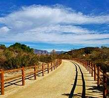
Outdoors: In addition to being a popular spot for mountain bikers, the city hosts a popular Southern California rock climbing venue called Santee Boulders.[19] Some common routes include "Moby Dick" and "Pride Rock" (located on the North Eastern section of the trail), as well as "Faith Hill" and "Dogpile" (located Northwest of the trail head). Santee Lakes[20] Regional Park and Campground offers 190 acres (77 ha) for fishing, camping, bird watching and picnicking. An unincorporated hiking area just north of Santee is popular for mountain bikers. It has entrances at Prince Valiant Drive and Princess Joann Drive and includes many trails that extend to Poway and Santee Lakes, as well as a boot-shaped rock on a slope, unsurprisingly nicknamed “Boot Rock”. In 2035, a community named Fanita Ranch is expected to be built in that area, requiring Magnolia Avenue and Cuyamaca Street to be extended northbound.
Golf: A local landmark since 1958, the Carlton Oaks Golf Course and resort offers a premier golfing destination.[21] The course was designed by Pete Dye, who was inducted into the World Golf Hall of Fame.
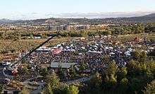
Music: A 10-week series of free concerts is organized each summer by the city's Community Services Department.[22] The Santee Wine & Bluegrass Festival,[23] a fund-raiser for local park and youth recreation programs, is held each fall at Town Center Community Park. Santee is also home to Off Broadway Live, a 100-seat, cabaret-style theatre. Off Broadway Live features year-round live theatre. Pickwick Players also performs at Off Broadway Live. Pickwick Players brings high quality community theatre productions and educational opportunities to adults, teens, and children.
Transportation
State Route 52 was extended eastward through the city from its former terminus at State Route 125 to State Route 67 on the city's east side. The city is bisected by four main thoroughfares: Mast Boulevard and Mission Gorge Road traverse east and west, while Magnolia Avenue and Cuyamaca Street cross north and south. Santee also is the eastern terminus of the San Diego Metropolitan Transit System (MTS) Green Line trolley route, which connects East County to Old Town and downtown San Diego. MTS also provides bus service. Gillespie Field, the oldest and largest of eight commercial aviation airports operated by San Diego County, is located on Santee's southern border with the city of El Cajon. The airport serves as a hub for local businesses. Also, while not public transportation, a classic 1960s or earlier Dodge Dart Coupe is often found street-parked on Cottonwood Avenue between Buena Vista Avenue and Gienke Lane.[24]
Public facilities
The 55 acres (22 ha) Town Center Community Park is located east of Cuyamaca Street along the San Diego River. The center of the park features a 15 acres (6.1 ha) sports field complex operated by Sportsplex USA Santee, and an aquatics center operated by the East County YMCA. The park's first two phases were completed in the fall of 2010. The $23.5 million facility was funded through a combination of redevelopment bonds, developer impact fees and grants.[25]
As of 2011, the city had completed about half of a 4-mile (6.4 km)-long riverfront trail system that will eventually connect with trails in Lakeside and Mission Trails Regional Park.
Located on 15 acres (6.1 ha) in Santee is the Las Colinas Detention Facility,[26] which serves as the primary point of intake for women prisoners in San Diego County. It began as a juvenile facility in 1967 and was converted to an adult women's institution in 1979.[27]
Geography
Santee, which is 345 feet (105 m) above sea level, shares the northern part of a valley with the city of El Cajon. The city is bisected by the San Diego River, which flows east to west for approximately 4.2 miles (6.8 km) within the city limits. Hills form a natural barrier on its northern and western sides.
Gillespie Field and Airfield Park act as a southern border with El Cajon. Prominently overlooking the western side of Santee is Cowles Mountain. This natural landmark, which is the highest point in the city of San Diego, offers sweeping views of the county and is a popular hiking destination. At an altitude of 1,198 feet, Rattlesnake Mountain is the highest point in Santee. Rattlesnake Mountain is home to the Sky Ranch community.
Climate
According to the Köppen Climate Classification system, Santee has a semi-arid climate, abbreviated "BSk" on climate maps.[28] Santee can get very hot and humid, even in winter, in the shade, and at night. Often at Cajon Park Elementary in the summer, it is so hot that the school does not let pupils go outside for lunch recess.
Demographics
| Historical population | |||
|---|---|---|---|
| Census | Pop. | %± | |
| 1970 | 21,107 | — | |
| 1980 | 47,080 | 123.1% | |
| 1990 | 52,902 | 12.4% | |
| 2000 | 52,975 | 0.1% | |
| 2010 | 53,413 | 0.8% | |
| Est. 2019 | 58,081 | [6] | 8.7% |
| U.S. Decennial Census[29] | |||
2010
At the 2010 census Santee had a population of 53,413. The population density was 3,231.6 people per square mile (1,247.7/km²). The racial makeup of Santee was 44,083 (82.5%) White, 1,057 (2.0%) African American, 409 (0.8%) Native American, 2,044 (3.8%) Asian (1.8% Filipino, 0.4% Chinese, 0.5% Vietnamese, 0.3% Japanese, 0.2% Korean, 0.2% Indian, 0.5% Other), 253 (0.5%) Pacific Islander, 2,677 (5.0%) from other races, and 2,890 (5.4%) from two or more races. Hispanic or Latino of any race were 8,699 persons (16.3%).[30]
The census reported that 52,447 people (98.2% of the population) lived in households, 77 (0.1%) lived in non-institutionalized group quarters, and 889 (1.7%) were institutionalized.
There were 19,306 households, of which 7,156 (37.1%) had children under the age of 18 living in them, 10,304 (53.4%) were opposite-sex married couples living together, 2,614 (13.5%) had a female householder with no husband present, 1,157 (6.0%) had a male householder with no wife present. There were 1,135 (5.9%) unmarried opposite-sex partnerships, and 119 (0.6%) same-sex married couples or partnerships. 3,986 households (20.6%) were one person and 1,534 (7.9%) had someone living alone who was 65 or older. The average household size was 2.72. There were 14,075 families (72.9% of households); the average family size was 3.13.
The age distribution was 12,710 people (23.8%) under the age of 18, 5,068 people (9.5%) aged 18 to 24, 14,790 people (27.7%) aged 25 to 44, 15,105 people (28.3%) aged 45 to 64, and 5,740 people (10.7%) who were 65 or older. The median age was 37.2 years. For every 100 females, there were 93.6 males. For every 100 females age 18 and over, there were 90.2 males.
There were 20,048 housing units at an average density of 1,212.9 per square mile, of the occupied units 13,576 (70.3%) were owner-occupied and 5,730 (29.7%) were rented.The homeowner vacancy rate was 1.5%; the rental vacancy rate was 4.0%. 36,198 people (67.8% of the population) lived in owner-occupied housing units and 16,249 people (30.4%) lived in rental housing units.
2000
As of the census[31] of 2000, there were 52,975 people in 18,470 households, including 14,018 families, in the city. The population density was 3,298.7 inhabitants per square mile (1,273.6/km2). There were 18,833 housing units at an average density of 1,172.7 per square mile (452.8/km2). The racial makeup of the city was 86.70% White, 1.48% African American, 0.81% Native American, 2.55% Asian, 0.41% Pacific Islander, 4.03% from other races, and 4.03% from two or more races. Hispanic or Latino of any race were 11.36% of the population.
Of the 18,470 households 40.9% had children under the age of 18 living with them, 57.7% were married couples living together, 13.0% had a female householder with no husband present, and 24.1% were non-families. 18.2% of households were one person and 6.9% were one person aged 65 or older. The average household size was 2.81 and the average family size was 3.19.
The age distribution was 28.2% under the age of 18, 8.4% from 18 to 24, 32.9% from 25 to 44, 21.6% from 45 to 64, and 8.9% 65 or older. The median age was 35 years. For every 100 females, there were 93.2 males. For every 100 females age 18 and over, there were 89.1 males.
Estimated median household income in 2008: $71,806 (up from $53,624 in 2000)
Santee: $71,806 California: $61,021
Estimated per capita income in 2008: $28,330
Estimated median house or condo value in 2008: $393,609 (it was $172,800 in 2000) Santee: $393,609 California: $467,000
Mean prices in 2008: All housing units: $358,473; Detached houses: $439,456; Townhouses or other attached units: $268,881; In 2-unit structures: $388,840; In 3-to-4-unit structures: $292,418; In 5-or-more-unit structures: $258,262; Mobile homes: $41,759; Occupied boats, RVs, vans, etc.: $95,000
Government
As of 2020, the Santee City Council was composed of Mayor John Minto, Vice Mayor Laura Koval and council members Stephen Houlihan, Ronn Hall, and Rob McNelis.[32]
In the California State Legislature, Santee is in the 38th Senate District, represented by Republican Brian Jones, and in the 71st Assembly District, represented by Republican Randy Voepel.[33]
In the United States House of Representatives, Santee is in California's 50th congressional district, seat currently vacant.[34]
Schools
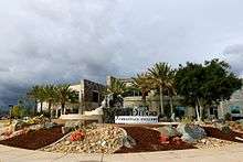
San Diego Christian College moved to Santee from El Cajon in early 2013. The college, which offers 15 degree programs, is accredited by the Western Association of Schools and Colleges. The college has approximately 475 students and 28 faculty members, but hopes to expand to as many as 1,200 students. [35]

Santee is served by two school districts: Santee School District and Grossmont Union High School District. The two high schools in Santee, West Hills High School and Santana High School, are both part of the Grossmont Union High School District. Elementary and middle schools are part of the Santee School District. Each school campus serves kindergarten through eighth grade (K-8). The schools are divided into elementary (K-6) and middle schools (7–8), with each using different parts of the campus and having different ending times. This is different from the traditional practice of smaller elementary schools that feed students into consolidated middle schools.
Elementary and middle school campuses
- Cajon Park School
- Carlton Hills School
- Carlton Oaks School
- Chet F. Harrit School
- Hill Creek School
- Pepper Drive School
- Pride Academy at Prospect Avenue School
- Rio Seco School
- Sycamore Canyon School
High schools
There are two high schools in Santee. Both are part of the Grossmont Union High School District.
On March 5, 2001, 15-year-old Charles Andrew Williams opened fire in a boys' bathroom and a grass quad area at Santana High School. Two students died and thirteen students were wounded. He pleaded guilty to the shooting and was sentenced to 50 years to life in prison.[36]
Notable people
- Sharon Ryer Davis, wife of former California Gov. Gray Davis, was raised in the city and crowned Miss Santee in 1968.[37]
- Brian Jones (born 1968), politician serving in the California State Senate
- Mega64, Internet sketch comedy group.[38]
- Dat Phan, stand-up comedian
- Stephen Strasburg, MLB pitcher, currently of the Washington Nationals, MVP of the 2019 World Series
- Marty Tripes, former professional motocross racer and member of the AMA Motorcycle Hall of Fame
See also
References
- ""Sustainable Santee" Opens 15-Acre Sports Complex - OPENINGS. - Parks & Recreation". Readperiodicals.com. Archived from the original on July 14, 2014. Retrieved February 18, 2016.
- "California Cities by Incorporation Date". California Association of Local Agency Formation Commissions. Archived from the original (Word) on November 3, 2014. Retrieved August 25, 2014.
- "2016 U.S. Gazetteer Files". United States Census Bureau. Archived from the original on August 24, 2017. Retrieved June 28, 2017.
- "Santee". Geographic Names Information System. United States Geological Survey. Retrieved December 14, 2014.
- "Santee (city) QuickFacts". United States Census Bureau. Archived from the original on March 23, 2015. Retrieved March 27, 2015.
- "Population and Housing Unit Estimates". Retrieved May 21, 2020.
- "The San Diego River: A Natural, Historic, and Recreational Resource" (PDF). Sdrc.ca.gov. Archived (PDF) from the original on November 11, 2010. Retrieved February 18, 2016.
- "The City of Santee: Santee's History". Ci.santee.ca.us. March 3, 2014. Archived from the original on October 27, 2008. Retrieved February 18, 2016.
- "By the numbers: Santee Crime Rates | Patch". Santee.patch.com. October 14, 2010. Archived from the original on July 15, 2011. Retrieved February 18, 2016.
- "The City of Santee : About Santee". Santee.patch.com. June 23, 2014. Archived from the original on May 5, 2010. Retrieved February 18, 2016.
- "Behind the swastikas in Santee". San Diego Reader. May 22, 2020. Retrieved May 30, 2020.
- Glionna, John M. (March 5, 2001). "Santee a 'Midwestern town in the heart of California'". Chicago Tribune. Retrieved June 6, 2020.
- Peralta, Hector (May 15, 2020). "Commentary: Santee is called 'Klantee' for a reason. We need to talk about it". San Diego Union Tribune.
- "Shopper in Swastika Mask Posts Video of Quarrel with Santee Deputies". Times of San Diego. Retrieved May 8, 2020.
- "Police Confront Customer In Swastika Mask In Same Town As Klan Hood Shopper". huffpost.com. Huffington Post. Retrieved May 9, 2020.
- "SANTEE LOVES: RESIDENTS RALLY IN VEHICLES TO STAND AGAINST HATE". eastcountymagazine.org. East County Magazine.
- "Santee rally held to combat hate with love". msn.com. Microsoft. Retrieved May 28, 2020.
- "About Santee". Archived from the original on August 10, 2011. Retrieved August 4, 2011.
- "Sandiego Rock" (PDF). Archived from the original (PDF) on June 12, 2009. Retrieved January 19, 2011.
- "Santee Lakes". Santee Lakes. Archived from the original on June 5, 2006. Retrieved February 18, 2016.
- "Carlton Oaks - San Diego's Premier Golf Course". Carltonoaksgolf.com. Archived from the original on February 1, 2011. Retrieved February 18, 2016.
- "The City of Santee : Special Events". Santee.patch.com. February 4, 2016. Archived from the original on November 5, 2010. Retrieved February 18, 2016.
- "The City of Santee : Santee Park & Recreation Committee (SPARC)". Ci.santee.ca.us. December 18, 2015. Archived from the original on September 29, 2011. Retrieved February 18, 2016.
- "Gillespie Field". Co.san-diego.ca.us. Archived from the original on November 5, 2010. Retrieved February 18, 2016.
- "The City of Santee : Town Center Community Park". Ci.santee.ca.us. Archived from the original on May 6, 2011. Retrieved February 18, 2016.
- "San Diego County Sheriff's Department". Sdsheriff.net. Archived from the original on April 20, 2010. Retrieved February 18, 2016.
- "San Diego County Sheriff's Department". Sdsheriff.net. Archived from the original on November 28, 2010. Retrieved February 18, 2016.
- "Santee, California Köppen Climate Classification". Weatherbase. Archived from the original on September 27, 2015. Retrieved February 18, 2016.
- "Census of Population and Housing". Census.gov. Retrieved June 4, 2015.
- "2010 Census Interactive Population Search: CA - Santee city". U.S. Census Bureau. Archived from the original on January 22, 2016. Retrieved July 12, 2014.
- "U.S. Census website". United States Census Bureau. Retrieved 2008-01-31.
- "City Council". The City of Santee. Archived from the original on November 5, 2012. Retrieved December 14, 2014.
- "Statewide Database". UC Regents. Archived from the original on February 1, 2015. Retrieved November 21, 2014.
- "California's 50th Congressional District - Representatives & District Map". Civic Impulse, LLC.
- "Photos: S.D. Christian College Holds Ribbon Cutting at". Santee.patch.com. February 26, 2013. Archived from the original on May 20, 2014. Retrieved February 18, 2016.
- "2 Dead, 13 Hurt in Calif. School Shooting". ABC News. March 5, 2001. Archived from the original on July 14, 2014. Retrieved May 6, 2011.
- "First Ladies of California". Firstladies.library.ca.gov. Archived from the original on December 17, 2010. Retrieved February 18, 2016.
- "Mega64 Podcast 314 - Santee". YouTube. July 25, 2014. Archived from the original on January 31, 2016. Retrieved February 18, 2016.
External links
| Wikimedia Commons has media related to Santee, California. |
| Counties | ||
|---|---|---|
| Major city | ||
| Cities 100k+ | ||
| Cities and towns 20k - 99k | ||
| CDPs 20k+ | ||
| Bodies of water | ||
| Regions |
| |
| Parks and Monuments | ||
| Authority control |
|
|---|