Uluberia subdivision
Uluberia subdivision is a subdivision of the Howrah district in the state of West Bengal, India. It consists of Uluberia municipality and nine community development (CD) blocks, including 90 gram panchayats and six census towns.[1] The six census towns are: Khalor, Bagnan, Naupala, Santoshpur, Balaram Pota and Uttar Pirpur.[2] The subdivision has its headquarters at Uluberia. The whole division forms the Lok Sabha constituency of Uluberia. [3]
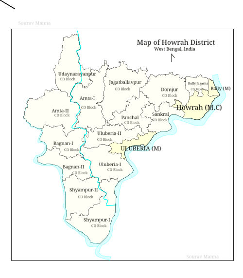
Map of Howrah District
Uluberia Sub-Division উলুবেড়িয়া মহকুমা | |
|---|---|
subdivision | |
 Uluberia Sub-Division Location in West Bengal, India  Uluberia Sub-Division Uluberia Sub-Division (India) | |
| Coordinates: 22.47°N 88.11°E | |
| Country | |
| State | West Bengal |
| District | Howrah |
| Headquarters | Uluberia |
| Languages | |
| • Official | Bengali, English |
| Time zone | UTC+5:30 (IST) |
| ISO 3166 code | ISO 3166-2:IN |
| Vehicle registration | WB |
| Website | wb |
Area
| Division | Headquarters[4] | Census town(s)[2] | Gram panchayats[1] | Police area[5] | West Bengal legislative area |
|---|---|---|---|---|---|
| Uluberia municipality | Uluberia | 0 | 0 | - | Uluberia Purba |
| Uluberia I | Uluberia | 0 | 9: Bahira, Hatgachha-I, Kalinagar, Chandipur, Hatgachha-II, Maheshpur, Birshibpur, Dhulasimla, Heerapur, Tapna. | Uluberia | Uluberia Dakshin |
| Uluberia II | Kusberia | 3: Santoshpur, Balaram Pota, Uttar Pirpur | 8: Baniban, Khalisani, Tehatta-Kantaberia-I, Tehatta-Kantaberia-II, Basudevpur, Raghudevpur, Joargori and Tulsiberia. | Uluberia | Uluberia Purba, Uluberia Uttar (SC) |
| Amta I | Amta | 0 | 13: Amta, Bhandargachha, Khosalpur, Udang–II, Anulia, Chandrapur, Raspur, Balichak, Kanpur, Sirajbati, Basantapur, Khardah and Udang–I | Amta | Udaynarayanpur, Uluberia Uttar (SC) |
| Amta II | Jaypur Fakirdas | 0 | 14: Amragori, Ghoraberia Chitnan, Khalna, Tajpur, Bhatora, Jhamtia, Kasmoli, Thalia, Binola Krishnabati, Jaypur, Kusberia, Gazipur, Jhikhira and Noyapara | Jaypur and Amta | Amta |
| Udaynarayanpur | Udaynaryanpur | 0 | 11: Bhabanipur Bidhichandrapur, Harali Udaynarayanpur, Khila, Rampur–Dihibhursut Asanda, Kurchi Shibpur, Debipur, Harishpu,Raghunathpur, Garbhabanipur–Sonatala, Kanupat Mansuka, Pancharul and Singti | Udaynarayanpur | Udaynarayanpur |
| Bagnan I | Bagnan | 2: Khalor, Bagnan | 10: Bagnan-I, Baksihat, Haturia-II, Sabsit, Bagnan-II, Bangalpur, Kalyanpur, Bainan, Haturia–I and Khalore | Bagnan | Bagnan, Amta |
| Bagnan II | Khalor | 1: Naupala | 7: Antila, Chandrabhag, Mugkalyan Benapur, Bantul–Baidyanathpur, Saratchandra, Halyan and Orphooli | Bagnan | Bagnan |
| Shyampur I | Shyampur | 0 | 10: Balichaturi, Belari, Kamalpur, Shyampur, Baneswarpur–I, Dhandali, Nabagram, Baneswarpur–II, Dingakhola and Radhapur | Shyampur | Uluberia Dakshin, Shyampur |
| Shyampur II | Sasati | 0 | 8: Amardaha, Bargram, Dihimondalghat–II, Nakol, Bachhri, Dihimondalghat-I, Kharuberia and Shashati | Shyampur | Shyampur |
Legislative segments
The whole of Uluberia subdivision elects to the Uluberia constituency of the Lok Sabha. [3] There are 7 constituencies for the West Bengal Legislative Assembly (Vidhan Sabha). The Uluberia Uttar constituency will be reserved for Scheduled castes (SC) candidates.
- Uluberia Purba (assembly constituency no. 176) - Uluberia municipality area and the gram panchayats of Khalisani and Raghudevpur under the Uluberia-II block
- Uluberia Uttar (SC) (assembly constituency no. 179) - the other six gram panchayats under the Uluberia-II block and eight gram panchayats under the Amta-I block: Amta, Bhandargachha, Chandrapur, Khardah, Raspur, Sirajbati, Udang-I and Udang-II
- Uluberia Dakshin (assembly constituency no. 180) - The Uluberia-I block and the gram panchayats of Belari, Dhandali, Balichaturi and Nabagram under the Shyampur-I block
- Shyampur (assembly constituency no. 181) - formed from the Shyampur-II CD block, and the other six gram panchayats under the Shyampur-I block
- Bagnan (assembly constituency no. 182) - formed from the whole Bagnan-II block, and the following gram panchayats of Bagnan-I: Bangalpur, Haturia-I, Haturia-II and Khalore
- Amta (assembly constituency no. 183) - formed from Amta-II and the other four gram panchayats under the Bagnan-I CD block
- Udaynarayanpur (assembly constituency no. 184) - formed from the Udaynarayanpur CD block, and from the other five gram panchayats from Amta I
References
- "Directory of District, Sub division, Panchayat Samiti/ Block and Gram Panchayats in West Bengal, March 2008". West Bengal. National Informatics Centre, India. 19 March 2008. Archived from the original on 25 February 2009. Retrieved 21 December 2008.
- "District Wise List of Statutory Towns( Municipal Corporation,Municipality,Notified Area and Cantonment Board), Census Towns and Outgrowths, West Bengal, 2001". Census of India, Directorate of Census Operations, West Bengal. Archived from the original on 30 September 2007. Retrieved 21 December 2008.
- "Press Note, Delimitation Commission" (PDF). Assembly Constituencies in West Bengal. Delimitation Commission. pp. 15, 24. Retrieved 18 January 2009.
- "Contact details of Block Development Officers". Howrah district. Panchayats and Rural Development Department, Government of West Bengal. Retrieved 26 December 2008.
- "List of Districts/C.D.Blocks/ Police Stations with Code No., Number of G.Ps and Number of Mouzas". Census of India, Directorate of Census Operations, West Bengal. Archived from the original on 16 April 2011. Retrieved 21 December 2008.
Cities, towns and locations in Howrah District | |
|---|---|
| Cities, municipal and census towns | |
| Locations other than cities and towns | |
| Related topics |
|
This article is issued from Wikipedia. The text is licensed under Creative Commons - Attribution - Sharealike. Additional terms may apply for the media files.