Sainte-Trie
Sainte-Trie is a commune in the Dordogne department in Nouvelle-Aquitaine in southwestern France.
Sainte-Trie | |
|---|---|
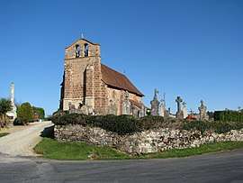 The church in Sainte-Trie | |
Location of Sainte-Trie 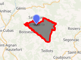
| |
 Sainte-Trie  Sainte-Trie | |
| Coordinates: 45°18′01″N 1°11′52″E | |
| Country | France |
| Region | Nouvelle-Aquitaine |
| Department | Dordogne |
| Arrondissement | Sarlat-la-Canéda |
| Canton | Haut-Périgord Noir |
| Government | |
| • Mayor (2008–2014) | Laurent Monteil |
| Area 1 | 10.91 km2 (4.21 sq mi) |
| Population (2017-01-01)[1] | 110 |
| • Density | 10/km2 (26/sq mi) |
| Time zone | UTC+01:00 (CET) |
| • Summer (DST) | UTC+02:00 (CEST) |
| INSEE/Postal code | 24507 /24160 |
| Elevation | 167–276 m (548–906 ft) (avg. 247 m or 810 ft) |
| 1 French Land Register data, which excludes lakes, ponds, glaciers > 1 km2 (0.386 sq mi or 247 acres) and river estuaries. | |
History
During the creation of the French departments in 1790, the commune first became part of the Corrèze department. It became part of the Dordogne department in 1793.
Population
| Historical population | ||
|---|---|---|
| Year | Pop. | ±% |
| 1962 | 138 | — |
| 1968 | 146 | +5.8% |
| 1975 | 134 | −8.2% |
| 1982 | 136 | +1.5% |
| 1990 | 118 | −13.2% |
| 1999 | 148 | +25.4% |
| 2008 | 125 | −15.5% |
See also
References
- "Populations légales 2017". INSEE. Retrieved 6 January 2020.
| Wikimedia Commons has media related to Sainte-Trie. |
| Authority control |
|
|---|
This article is issued from Wikipedia. The text is licensed under Creative Commons - Attribution - Sharealike. Additional terms may apply for the media files.