Saint-Paul-en-Cornillon
Saint-Paul-en-Cornillon is a commune in the Loire department in central France.
Saint-Paul-en-Cornillon | |
|---|---|
Commune | |
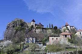 The upper village | |
.svg.png) Coat of arms | |
Location of Saint-Paul-en-Cornillon 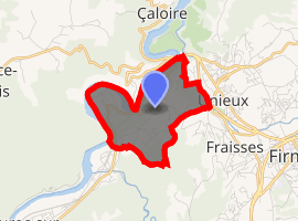
| |
 Saint-Paul-en-Cornillon  Saint-Paul-en-Cornillon | |
| Coordinates: 45°23′53″N 4°14′29″E | |
| Country | France |
| Region | Auvergne-Rhône-Alpes |
| Department | Loire |
| Arrondissement | Saint-Étienne |
| Canton | Firminy |
| Intercommunality | Saint-Étienne Métropole |
| Government | |
| • Mayor (2014-2020) | Sylvie Fayolle |
| Area 1 | 3.72 km2 (1.44 sq mi) |
| Population (2017-01-01)[1] | 1,364 |
| • Density | 370/km2 (950/sq mi) |
| Time zone | UTC+01:00 (CET) |
| • Summer (DST) | UTC+02:00 (CEST) |
| INSEE/Postal code | 42270 /42240 |
| Elevation | 422–713 m (1,385–2,339 ft) (avg. 430 m or 1,410 ft) |
| 1 French Land Register data, which excludes lakes, ponds, glaciers > 1 km2 (0.386 sq mi or 247 acres) and river estuaries. | |
Population
| Historical population | ||
|---|---|---|
| Year | Pop. | ±% |
| 1793 | 462 | — |
| 1800 | 582 | +26.0% |
| 1806 | 626 | +7.6% |
| 1821 | 487 | −22.2% |
| 1831 | 592 | +21.6% |
| 1836 | 576 | −2.7% |
| 1841 | 536 | −6.9% |
| 1846 | 543 | +1.3% |
| 1851 | 548 | +0.9% |
| 1856 | 514 | −6.2% |
| 1861 | 656 | +27.6% |
| 1866 | 686 | +4.6% |
| 1872 | 514 | −25.1% |
| 1876 | 537 | +4.5% |
| 1881 | 526 | −2.0% |
| 1886 | 659 | +25.3% |
| 1891 | 582 | −11.7% |
| 1896 | 607 | +4.3% |
| 1901 | 585 | −3.6% |
| 1906 | 594 | +1.5% |
| 1911 | 581 | −2.2% |
| 1921 | 550 | −5.3% |
| 1926 | 505 | −8.2% |
| 1931 | 512 | +1.4% |
| 1936 | 515 | +0.6% |
| 1946 | 509 | −1.2% |
| 1954 | 607 | +19.3% |
| 1962 | 633 | +4.3% |
| 1968 | 598 | −5.5% |
| 1975 | 672 | +12.4% |
| 1982 | 1,045 | +55.5% |
| 1990 | 1,122 | +7.4% |
| 1999 | 1,304 | +16.2% |
| 2005 | 1,319 | +1.2% |
| 2006 | 1,301 | −1.4% |
| 2007 | 1,288 | −1.0% |
| 2008 | 1,299 | +0.9% |
| 2009 | 1,310 | +0.8% |
| 2010 | 1,321 | +0.8% |
| 2011 | 1,331 | +0.8% |
| 2012 | 1,339 | +0.6% |
| 2013 | 1,345 | +0.4% |
| 2014 | 1,352 | +0.5% |
Gallery
- Castle of Saint Paul en Cornillon (11th Century)
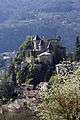 The château
 A view from the south
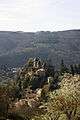 A view from the east
See also
References
- "Populations légales 2017". INSEE. Retrieved 6 January 2020.
| Wikimedia Commons has media related to Saint-Paul-en-Cornillon. |
| Authority control |
|
|---|
This article is issued from Wikipedia. The text is licensed under Creative Commons - Attribution - Sharealike. Additional terms may apply for the media files.