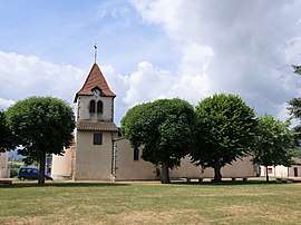
Saint-Forgeux-Lespinasse
Saint-Forgeux-Lespinasse is a commune in the Loire department in central France.
Saint-Forgeux-Lespinasse | |
|---|---|
Commune | |
 | |
.svg.png) Coat of arms | |
Location of Saint-Forgeux-Lespinasse 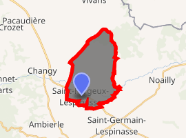
| |
 Saint-Forgeux-Lespinasse  Saint-Forgeux-Lespinasse | |
| Coordinates: 46°07′27″N 3°55′55″E | |
| Country | France |
| Region | Auvergne-Rhône-Alpes |
| Department | Loire |
| Arrondissement | Roanne |
| Canton | Renaison |
| Intercommunality | Pays de la Pacaudière |
| Government | |
| • Mayor (2014–2020) | Jean-Paul Berger |
| Area 1 | 16.19 km2 (6.25 sq mi) |
| Population (2017-01-01)[1] | 646 |
| • Density | 40/km2 (100/sq mi) |
| Time zone | UTC+01:00 (CET) |
| • Summer (DST) | UTC+02:00 (CEST) |
| INSEE/Postal code | 42220 /42640 |
| Elevation | 287–363 m (942–1,191 ft) (avg. 322 m or 1,056 ft) |
| 1 French Land Register data, which excludes lakes, ponds, glaciers > 1 km2 (0.386 sq mi or 247 acres) and river estuaries. | |
Population
| Historical population | ||
|---|---|---|
| Year | Pop. | ±% |
| 1793 | 850 | — |
| 1806 | 575 | −32.4% |
| 1821 | 583 | +1.4% |
| 1831 | 558 | −4.3% |
| 1841 | 553 | −0.9% |
| 1851 | 579 | +4.7% |
| 1861 | 599 | +3.5% |
| 1872 | 671 | +12.0% |
| 1881 | 665 | −0.9% |
| 1891 | 699 | +5.1% |
| 1901 | 681 | −2.6% |
| 1911 | 595 | −12.6% |
| 1921 | 507 | −14.8% |
| 1931 | 486 | −4.1% |
| 1946 | 465 | −4.3% |
| 1954 | 439 | −5.6% |
| 1962 | 468 | +6.6% |
| 1968 | 437 | −6.6% |
| 1975 | 385 | −11.9% |
| 1982 | 404 | +4.9% |
| 1990 | 416 | +3.0% |
| 1999 | 416 | +0.0% |
| 2010 | 538 | +29.3% |
| 2016 | 640 | +19.0% |
See also
References
- "Populations légales 2017". INSEE. Retrieved 6 January 2020.
| Wikimedia Commons has media related to Saint-Forgeux-Lespinasse. |
| Authority control |
|
|---|
This article is issued from Wikipedia. The text is licensed under Creative Commons - Attribution - Sharealike. Additional terms may apply for the media files.