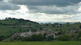
Saint-Cyr-de-Valorges
Saint-Cyr-de-Valorges is a commune in the Loire department in central France.
Saint-Cyr-de-Valorges | |
|---|---|
Commune | |
 | |
Location of Saint-Cyr-de-Valorges 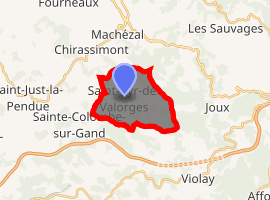
| |
 Saint-Cyr-de-Valorges  Saint-Cyr-de-Valorges | |
| Coordinates: 45°53′32″N 4°18′25″E | |
| Country | France |
| Region | Auvergne-Rhône-Alpes |
| Department | Loire |
| Arrondissement | Roanne |
| Canton | Le Coteau |
| Intercommunality | Balbigny |
| Government | |
| • Mayor (2020–2026) | Gilbert Grataloup |
| Area 1 | 9.91 km2 (3.83 sq mi) |
| Population (2017-01-01)[1] | 304 |
| • Density | 31/km2 (79/sq mi) |
| Time zone | UTC+01:00 (CET) |
| • Summer (DST) | UTC+02:00 (CEST) |
| INSEE/Postal code | 42213 /42114 |
| Elevation | 526–892 m (1,726–2,927 ft) (avg. 640 m or 2,100 ft) |
| 1 French Land Register data, which excludes lakes, ponds, glaciers > 1 km2 (0.386 sq mi or 247 acres) and river estuaries. | |
Population
| Historical population | ||
|---|---|---|
| Year | Pop. | ±% |
| 1793 | 680 | — |
| 1806 | 678 | −0.3% |
| 1821 | 798 | +17.7% |
| 1831 | 997 | +24.9% |
| 1841 | 904 | −9.3% |
| 1851 | 900 | −0.4% |
| 1961 | 879 | −2.3% |
| 1872 | 865 | −1.6% |
| 1881 | 756 | −12.6% |
| 1891 | 704 | −6.9% |
| 1901 | 717 | +1.8% |
| 1911 | 678 | −5.4% |
| 1921 | 550 | −18.9% |
| 1931 | 474 | −13.8% |
| 1946 | 399 | −15.8% |
| 1954 | 377 | −5.5% |
| 1962 | 396 | +5.0% |
| 1968 | 383 | −3.3% |
| 1975 | 358 | −6.5% |
| 1982 | 313 | −12.6% |
| 1990 | 277 | −11.5% |
| 1999 | 274 | −1.1% |
| 2009 | 354 | +29.2% |
| 2016 | 301 | −15.0% |
See also
References
- "Populations légales 2017". INSEE. Retrieved 6 January 2020.
| Wikimedia Commons has media related to Saint-Cyr-de-Valorges. |
| Authority control |
|
|---|
This article is issued from Wikipedia. The text is licensed under Creative Commons - Attribution - Sharealike. Additional terms may apply for the media files.