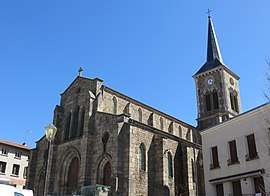
Saint-Maurice-en-Gourgois
Saint-Maurice-en-Gourgois is a commune in the Loire department in central France.
Saint-Maurice-en-Gourgois | |
|---|---|
Commune | |
 | |
.svg.png) Coat of arms | |
Location of Saint-Maurice-en-Gourgois 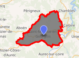
| |
 Saint-Maurice-en-Gourgois  Saint-Maurice-en-Gourgois | |
| Coordinates: 45°24′08″N 4°11′02″E | |
| Country | France |
| Region | Auvergne-Rhône-Alpes |
| Department | Loire |
| Arrondissement | Montbrison |
| Canton | Saint-Just-Saint-Rambert |
| Intercommunality | Saint-Étienne Métropole |
| Government | |
| • Mayor (2014–2020) | Bernard Bonnet |
| Area 1 | 31.83 km2 (12.29 sq mi) |
| Population (2017-01-01)[1] | 1,813 |
| • Density | 57/km2 (150/sq mi) |
| Time zone | UTC+01:00 (CET) |
| • Summer (DST) | UTC+02:00 (CEST) |
| INSEE/Postal code | 42262 /42240 |
| Elevation | 422–816 m (1,385–2,677 ft) (avg. 790 m or 2,590 ft) |
| 1 French Land Register data, which excludes lakes, ponds, glaciers > 1 km2 (0.386 sq mi or 247 acres) and river estuaries. | |
Population
| Historical population | ||
|---|---|---|
| Year | Pop. | ±% |
| 1793 | 2,400 | — |
| 1806 | 1,804 | −24.8% |
| 1821 | 1,862 | +3.2% |
| 1831 | 2,184 | +17.3% |
| 1841 | 2,510 | +14.9% |
| 1851 | 2,516 | +0.2% |
| 1861 | 2,434 | −3.3% |
| 1872 | 2,004 | −17.7% |
| 1881 | 1,995 | −0.4% |
| 1891 | 1,925 | −3.5% |
| 1901 | 1,764 | −8.4% |
| 1911 | 1,611 | −8.7% |
| 1921 | 1,373 | −14.8% |
| 1931 | 1,322 | −3.7% |
| 1946 | 1,057 | −20.0% |
| 1954 | 1,012 | −4.3% |
| 1962 | 927 | −8.4% |
| 1968 | 823 | −11.2% |
| 1975 | 754 | −8.4% |
| 1982 | 859 | +13.9% |
| 1990 | 1,006 | +17.1% |
| 1999 | 1,277 | +26.9% |
| 2011 | 1,743 | +36.5% |
| 2017 | 1,813 | +4.0% |
See also
References
- "Populations légales 2017". INSEE. Retrieved 6 January 2020.
| Wikimedia Commons has media related to Saint-Maurice-en-Gourgois. |
| Authority control |
|
|---|
This article is issued from Wikipedia. The text is licensed under Creative Commons - Attribution - Sharealike. Additional terms may apply for the media files.