Saint-Léon-sur-l'Isle
Saint-Léon-sur-l'Isle (Limousin: Sent Leu d’Eila) is a commune in the Dordogne department in Nouvelle-Aquitaine in southwestern France.
Saint-Léon-sur-l'Isle | |
|---|---|
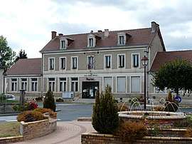 The town hall in Saint-Léon-sur-l'Isle | |
Location of Saint-Léon-sur-l'Isle 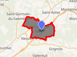
| |
 Saint-Léon-sur-l'Isle  Saint-Léon-sur-l'Isle | |
| Coordinates: 45°06′56″N 0°30′19″E | |
| Country | France |
| Region | Nouvelle-Aquitaine |
| Department | Dordogne |
| Arrondissement | Périgueux |
| Canton | Saint-Astier |
| Intercommunality | Astérienne Isle et Vern |
| Government | |
| • Mayor (2008–2014) | Claude Parade |
| Area 1 | 14.78 km2 (5.71 sq mi) |
| Population (2017-01-01)[1] | 2,027 |
| • Density | 140/km2 (360/sq mi) |
| Time zone | UTC+01:00 (CET) |
| • Summer (DST) | UTC+02:00 (CEST) |
| INSEE/Postal code | 24442 /24110 |
| Elevation | 56–192 m (184–630 ft) (avg. 73 m or 240 ft) |
| 1 French Land Register data, which excludes lakes, ponds, glaciers > 1 km2 (0.386 sq mi or 247 acres) and river estuaries. | |
Population
| Historical population | ||
|---|---|---|
| Year | Pop. | ±% |
| 1793 | 1,009 | — |
| 1800 | 968 | −4.1% |
| 1806 | 1,037 | +7.1% |
| 1821 | 1,011 | −2.5% |
| 1831 | 1,058 | +4.6% |
| 1836 | 1,073 | +1.4% |
| 1841 | 1,093 | +1.9% |
| 1846 | 1,032 | −5.6% |
| 1851 | 1,062 | +2.9% |
| 1856 | 1,013 | −4.6% |
| 1861 | 998 | −1.5% |
| 1866 | 1,016 | +1.8% |
| 1872 | 913 | −10.1% |
| 1876 | 895 | −2.0% |
| 1881 | 960 | +7.3% |
| 1886 | 985 | +2.6% |
| 1891 | 978 | −0.7% |
| 1896 | 897 | −8.3% |
| 1901 | 918 | +2.3% |
| 1906 | 870 | −5.2% |
| 1911 | 786 | −9.7% |
| 1921 | 679 | −13.6% |
| 1926 | 668 | −1.6% |
| 1931 | 676 | +1.2% |
| 1936 | 683 | +1.0% |
| 1946 | 708 | +3.7% |
| 1954 | 745 | +5.2% |
| 1962 | 842 | +13.0% |
| 1968 | 1,436 | +70.5% |
| 1975 | 1,708 | +18.9% |
| 1982 | 1,872 | +9.6% |
| 1990 | 1,934 | +3.3% |
| 1999 | 1,877 | −2.9% |
| 2008 | 1,983 | +5.6% |
See also
References
- "Populations légales 2017". INSEE. Retrieved 6 January 2020.
| Wikimedia Commons has media related to Saint-Léon-sur-l'Isle. |
| Authority control |
|
|---|
This article is issued from Wikipedia. The text is licensed under Creative Commons - Attribution - Sharealike. Additional terms may apply for the media files.