Saint-Georges, French Guiana
Saint-Georges (sometimes unofficially called Saint-Georges-de-l'Oyapock) is a commune of French Guiana, an overseas region and department of France located in South America. It lies on the Oyapock River (which forms the border with Brazil), opposite the Brazilian town of Oiapoque. The town contains a town hall, a French Foreign Legion detachment,[2] and some hotels (the main ones being Le Tamarin, Coz Calè and the Chez Modestine).
Saint-Georges | |
|---|---|
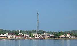 A view of Saint-George from the river | |
 Location of the commune (in red) within French Guiana | |
Location of Saint-Georges 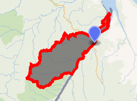
| |
| Coordinates: 3°53′20″N 51°48′04″W | |
| Country | France |
| Overseas region and department | French Guiana |
| Arrondissement | Cayenne |
| Intercommunality | Est Guyanais |
| Government | |
| • Mayor (2014-2020) | Georges Elfort (DVG) |
| Area 1 | 2,320 km2 (900 sq mi) |
| Population (2017)[1] | 4,220 |
| • Density | 1.8/km2 (4.7/sq mi) |
| Time zone | UTC−03:00 |
| INSEE/Postal code | 97308 /97313 |
| 1 French Land Register data, which excludes lakes, ponds, glaciers > 1 km2 (0.386 sq mi or 247 acres) and river estuaries. | |
History
The town was founded on 23 April 1853 as a penal colony and named after a Dutch coin of Saint George which was discovered at the site. The camp was closed down in 1863. The discovery of gold in 1885 in the Camopi River revived the hamlet and the town was officially created in 1947.[3]
Transport
An asphalted road from Saint-Georges to Régina was opened in 2004, completing the National Road 2 (RN2) from Cayenne (the préfecture and largest city of French Guiana) to the Brazilian border and ending the isolation of Saint-Georges. It is now possible to drive on a fully paved road from Saint-Laurent-du-Maroni on the Surinamese border to Saint-Georges on the Brazilian border.[4]
Following an international treaty between France and Brazil signed in 15 July 2005,[5] the Oyapock River Bridge was built and was opened in March 2017. This bridge is the first land crossing ever opened between France and Brazil, and indeed between French Guiana and the rest of the world (there exists no other bridge crossing the Oyapock River, and no bridge crossing the Maroni River marking the border with Suriname). When the bridge was opened, it is possible to drive uninterrupted from Cayenne to Macapá (on the Amazon River), the capital of the state of Amapá in Brazil.[6]
Saint-Georges is served by the Saint-Georges-de-l'Oyapock Airport.
See also
References
- "Populations légales 2017 Commune de Saint-Georges (97308)". National Institute of Statistics and Economic Studies. Retrieved 11 May 2020.
- "Les Forces Armées en Guyane". Ministry of Defence of the French Republic (in French). Retrieved 11 May 2020.
- "Saint-Georges". Americas.fr (in French). Retrieved 11 May 2020.
- "Le secteur des transports dans les DCOM (Page 37)". Study Lib.fr (in French). Retrieved 11 May 2020.
- "Projet de loi autorisant l'approbation de l'accord entre le Gouvernement de la République française et le Gouvernement de la République fédérative du Brésil relatif à la construction d'un pont routier sur le fleuve Oyapock reliant la Guyane française et l'État de l'Ama". Senate of the French Republic (in French). Retrieved 11 May 2020.
- "Le pont de l'Oyapock inauguré et officiellement ouvert à la circulation". Guyane la 1ère (in French). Retrieved 11 May 2020.
External links
| Wikimedia Commons has media related to Saint-Georges (Guyane). |
| Authority control |
|
|---|