Roura, French Guiana
Roura is a commune of French Guiana, an overseas region and department of France located in South America. The city of Roura is bordered by Matoury and Montsinéry-Tonnegrande in the North, Kourou and Saint-Elie in the North West and West, and finally by Régina in the South and East.[2]
Roura | |
|---|---|
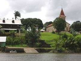 Roura as seen from the Oyak River | |
.svg.png) Coat of arms | |
 Location of the commune (in red) within French Guiana | |
Location of Roura 
| |
| Coordinates: 4°43′27″N 52°19′17″W | |
| Country | France |
| Overseas region and department | French Guiana |
| Arrondissement | Cayenne |
| Intercommunality | Centre Littoral |
| Government | |
| • Mayor (2014-2020) | David Riché |
| Area 1 | 3,902.5 km2 (1,506.8 sq mi) |
| Population (2017-01-01)[1] | 3,783 |
| • Density | 0.97/km2 (2.5/sq mi) |
| Time zone | UTC−03:00 |
| INSEE/Postal code | 97310 /97311 |
| Elevation | 0–462 m (0–1,516 ft) (avg. 231 m or 758 ft) |
| 1 French Land Register data, which excludes lakes, ponds, glaciers > 1 km2 (0.386 sq mi or 247 acres) and river estuaries. | |
History
The town of Roura was founded in 1675 by Jesuits. In 1786, Marquis de Lafayette attempted an early emancipation of the slaves by allowing small scale agriculture on the savanna Gabriel near Roury. The experiment failed, and was abandoned in 1796/[3] In 1848, slavery was finally abolished.[4]
In 1998, the Kaw-Roura Marshland Nature Reserve was established, and covers an area of 94,700 hectares between Roura and Régina.[5]
Roads
The city of Roura is home to 2 main roads.
See also
References
- "Populations légales 2017". INSEE. Retrieved 6 January 2020.
- "City of Roura". Map France (in French). Retrieved 1 June 2020.
- "Vestiges archéologiques". Roura.gf (in French). Retrieved 1 June 2020.
- "Histoire de la commune". Roura.gf (in French). Retrieved 1 June 2020.
- "KAW-ROURA MARSHLANDS NATURE RESERVE". Petit Futé (in French). Retrieved 1 June 2020.
- "Etude de la biodiversité et des paysages dans le cadre de l'aménagement et l'entretien de la route RD6, communes de Roura et Régina, Guyane" (PDF). Reserves Naturelles (in French). Retrieved 1 June 2020.
- "Prudence, nouveau glissement de terrain sur la RN2 à 40 kilomètres de l'intersection de Cacao". Guyane, la Première (in French). Retrieved 31 May 2020.
- "Des Hmongs en Guyane". ANAI Asso.org (National Association of Elders and Friends of Indochina) (in French). Retrieved 31 May 2020.
External links
- Official website of the commune (in French)
| Wikimedia Commons has media related to Roura. |
| Authority control |
|---|