Arrondissement of Cayenne
The arrondissement of Cayenne is an arrondissement of France in French Guiana department in French Guiana region. It has 14 communes.[1] Its population is 176,357 (2016), and its area is 42,589 km2 (16,444 sq mi).[2] It is the larger of the two arrondissements in French Guiana.
Cayenne | |
|---|---|
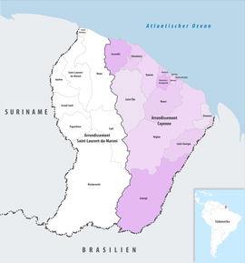 Location within French Guiana | |
| Country | France |
| Overseas region and department | French Guiana |
| No. of communes | 14 |
| Prefecture | Cayenne |
| Area | |
| • Total | 42,589 km2 (16,444 sq mi) |
| Population (2016) | |
| • Total | 176,357 |
| • Density | 4/km2 (10/sq mi) |
| INSEE code | 9731 |
Composition
The communes of the arrondissement of Cayenne, and their INSEE codes, are:[1]
- Camopi (97356)
- Cayenne (97302)
- Iracoubo (97303)
- Kourou (97304)
- Macouria (97305)
- Matoury (97307)
- Montsinéry-Tonnegrande (97313)
- Ouanary (97314)
- Remire-Montjoly (97309)
- Roura (97310)
- Régina (97301)
- Saint-Georges (97308)
- Saint-Élie (97358)
- Sinnamary (97312)
History
The arrondissement of Cayenne, containing the coastal strip of French Guiana, was established in 1947.[3] In 1969 the arrondissement of Inini, which covered the inland territory of French Guiana, was disbanded, and the territory of French Guiana was divided between the arrondissement of Cayenne and the new arrondissement of Saint-Laurent-du-Maroni.[4]
Before 2015, the arrondissements of French Guiana were subdivided into cantons. The cantons of the arrondissement of Cayenne were, as of January 2015:[5]
- Approuague-Kaw
- Cayenne 1st Canton Nord-Ouest
- Cayenne 2nd Canton Nord-Est
- Cayenne 3rd Canton Sud-Ouest
- Cayenne 4th Canton Centre
- Cayenne 5th Canton Sud
- Cayenne 6th Canton Sud-Est
- Iracoubo
- Kourou
- Macouria
- Matoury
- Montsinéry-Tonnegrande
- Rémiré-Montjoly
- Roura
- Saint-Georges-de-l'Oyapock
- Sinnamary
References
- "Arrondissement de Cayenne (9731)". INSEE. Retrieved 2019-10-06.
- "Comparateur de territoire, géographie au 01/01/2019". INSEE. Retrieved 2019-10-06.
- Décret n° 47-1018 du 7 juin 1947 relatif à l'organisation départementale et à l'institution préfectorale dans les départements de la Guadeloupe, de la Guyane française, de la Martinique et de la Réunion
- Décret n°69-261 du 17 mars 1969
- "Populations légales 2012" (PDF). INSEE. December 2014. Retrieved 2019-10-06.