Iracoubo
Iracoubo is a commune on the coast of French Guiana, an overseas region and department of France located in South America.
Iracoubo | |
|---|---|
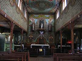 View of the Church decorated by Pierre Huguet, a convict | |
.svg.png) Coat of arms | |
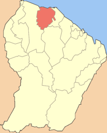 Location of the commune (in red) within French Guiana | |
Location of Iracoubo 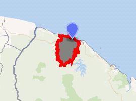
| |
| Coordinates: 5°28′46″N 53°12′14″W | |
| Country | France |
| Overseas region and department | French Guiana |
| Arrondissement | Cayenne |
| Intercommunality | CC des Savanes |
| Government | |
| • Mayor (2014-2020) | Cornélie Sellali Bois-Blanc |
| Area 1 | 2,762 km2 (1,066 sq mi) |
| Population (2012) | 1,955 |
| • Density | 0.71/km2 (1.8/sq mi) |
| Time zone | UTC−03:00 |
| INSEE/Postal code | 97303 /97350 |
| 1 French Land Register data, which excludes lakes, ponds, glaciers > 1 km2 (0.386 sq mi or 247 acres) and river estuaries. | |
Geography
The settlement of Iracoubo, seat of the commune, is located between the settlement of Sinnamary and the hamlet of Organabo.[1]
The village of Bellevue is 5 km west of Iracoubo.
History
The commune was originally settled by Amerindians near Organabo. The first settlers arrived in 1626, but were driven back. In 1765, the Galibis who had left the area for Suriname because an epidimic had broken out, returned.[2]
In the beginning of the 19th century, Iracoubo started as a cotton plantation owned by Colonel Jacquet. In 1859, the cotton shed is donated to the community to serve as church. In the late 19th century indigenous Galibi along the Rococoua river in Counama and Organabo.[1] In 1886 Father Raffray arrived in the village,[3] and started to build the Saint-Joseph church which opened in 1893. Saint-Joseph became a monument in 1978.[4]
In 1912, the introduction of bananas and rosewood strengthened the economy which remains based on agriculture, hunting and fishing.[1] Iracoubo is located on the Route National 1 connecting Saint-Laurent-du-Maroni to Cayenne. [3]
Organabo
Organabo is a Galibi village located in the commune. As of 2020, the population is about 200 people, and consisted mainly of elderly people, because the youth had moved on to the city.[5] The village used to be on the estuary of the Iracaoubo River facing the Atlantic Ocean, but is now several kilometres land inwards.[6] The population primarily lives from fishing,[6] and agriculture. In December 2018, the villagers were given communal land.[7] The village is self sufficient,[5] and therefore self isolated during the COVID-19 pandemic of 2020.[5]
See also
References
- "Guide Iracoubo". Petit Futé. Retrieved 2 June 2020.
- "Historie de la commune". Iracoubo.fr (in French). Retrieved 3 June 2020.
- "Iracoubo". Guyane Guide (in Dutch). Retrieved 2 June 2020.
- "Eglise Saint-Joseph". Pop.Culture.Gouv.fr (in French). Retrieved 2 June 2020.
- "Coronavirus : Organabo un hameau sur le territoire d'Iracoubo paisiblement confiné". Guyane, le Première (in French). Retrieved 5 June 2020.
- "Villages amérindiens et petites habitations créoles à Sinnamary et Iracoubo". Une Saison en Guyane (in French). Retrieved 5 June 2002.
- "Zones de Droits d'Usage Collectifs dans les villages de Bellevue et Organabo" (in French). Retrieved 5 June 2020.
External links
- Official website (in French)
| Wikimedia Commons has media related to Iracoubo. |
| Authority control |
|
|---|