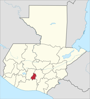
Sacatepéquez Department
Sacatepéquez (Spanish pronunciation: [sakateˈpekes]) is one of the 22 departments of Guatemala. The name comes from Sacatepéquez, a city from November 21, 1542 until July 29, 1773 when it was destroyed by the 1773 Guatemalan Earthquake (San Martha Earthquake). Sacatepéquez means grasshill in the Nahuatl language. The capital of Sacatepéquez is Antigua Guatemala which is home to an extensive textile marketplace. Other important cities include Ciudad Vieja and San Lucas Sacatepéquez, which also hosts a marketplace and is a culinary attraction. The Chajoma were a group of indigenous people who were Kaqchikel speaking Indians identified Mixco Viejo as their capital, and spread throughout the Sacatepequez Department until their capital was moved to Ciudad Vieja, in Antigua.
Sacatepéquez Department Departmento de Sacatepéquez | |
|---|---|
 Flag  Coat of arms | |
 Sacatepéquez | |
| Country | |
| Capital | Antigua Guatemala |
| Municipalities | 16 |
| Government | |
| • Type | Departmental |
| Area | |
| • Department of Guatemala | 465 km2 (180 sq mi) |
| Population (2018)[1] | |
| • Department of Guatemala | 330,469 |
| • Density | 710/km2 (1,800/sq mi) |
| • Urban | 292,366 |
| • Religions | Roman Catholicism, Evangelicalism, Maya |
| Time zone | UTC-6 |
Name
Sacatepéquez has also been spelled Zacatepeques.[2]
Population
Sacatepéquez Department has a population of 330,469 (2018 census).[1] In 1850, the area had a population of an estimated 56,000. The southern area, which is closer to Guatemala City, has the largest population.[3]
Municipalities
- Alotenango
- Antigua Guatemala
- Ciudad Vieja
- Jocotenango
- Magdalena Milpas Altas
- Pastores
- San Antonio Aguas Calientes
- San Bartolomé Milpas Altas
- San Lucas Sacatepéquez
- San Miguel Dueñas
- Santiago Sacatepéquez
- Santa Catarina Barahona
- Santa Lucía Milpas Altas
- Santa María de Jesús
- Santo Domingo Xenacoj
- Sumpango
Geography
The area is mountainous, with what the British described, in 1850, as a "mild climate."[2] Guatemala hosts a chain of active and dormant volcanoes, with those in Sacatepequez including Acatenago, Volcan De Agua (Volcano of Water), and Volcan de Fuego (Volcano of Fire).[4] Jocotes, a fruit of the cashew family, grow in the region.[5]
Economy
The more populated areas produce fruit and various crops, including maize. Livestock is also raised, with trade going towards Guatemala City. The southern area of the department produces coffee, sugar, tobacco, and cotton. As of 1850, products were being shipped out of Iztapa.[3] Although Guatemala is able to produce cash crops such as bananas and textiles, 72% of people living in rural areas live in poverty with 31% of them reaching extreme poverty.[6]
See also
References
- Citypopulation.de Population of departments in Guatemala
- Baily, John (1850). Central America; Describing Each of the States of Guatemala, Honduras, Salvador, Nicaragua, and Costa Rica. London: Trelawney Saunders. p. 76.
- Baily, John (1850). Central America; Describing Each of the States of Guatemala, Honduras, Salvador, Nicaragua, and Costa Rica. London: Trelawney Saunders. p. 77.
- Landmeier, Phillip. "The Volcanos of Guatemala". www.mayaparaiso.com. Retrieved 2017-05-10.
- "Guatemala's "National Fruit" – The Jocote - Qué Pasa Magazine". www.quepasa.gt. Retrieved 2017-05-10.
- Huber-Warring, Tonya (2008-01-01). Growing a Soul for Social Change: Building the Knowledge Base for Social Justice. IAP. ISBN 9781593118877.