Jutiapa Department
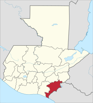
Jutiapa Department is a department of Guatemala that borders along El Salvador and the Pacific Ocean. The capital is the city of Jutiapa. As of 2018, it has a population of 488,395[1]. The department is divided into seventeen municipalities. Jutiapa is the country's southeastern-most department. The main crops are sorghum, tobacco, onion and corn. The climate is dry. An important attraction is the cattle fair. It is at 405 m above sea level.
Jutiapa Department Departmento de Jutiapa | |
|---|---|
 Flag  Coat of arms | |
 Jutiapa | |
| Country | |
| Capital | Jutiapa |
| Municipalities | 17 |
| Government | |
| • Type | Departmental |
| Area | |
| • Department of Guatemala | 3,219 km2 (1,243 sq mi) |
| Population (2018)[1] | |
| • Department of Guatemala | 488,395 |
| • Density | 150/km2 (390/sq mi) |
| • Urban | 249,754 |
| • Religions | Roman Catholicism, Evangelicalism |
| Time zone | UTC-6 |
The population is ethnically "mestizo" (European and indigenous), though in the northern regions of Jutiapa there are few descendants that once belonged to the now extinct Xinca population. The indigenous population is non existent today in Jutiapa with traditional language and culture no longer conserved or practiced.
The coat of arms contains the cornucopia symbolizing Jutiapa as the barn of the East, supplying Guatemala with most of the grain consumed by the people. The horse and the cow represent the cattle; the books stand for educational and cultural advances. In the background sits La Cruz hill, the firm guardian of the departmental chief town, with the tower or antenna of a Jutiapa radio station. Behind the hill float the clouds, the sky and the sun of Jutiapa, "The Sun City". This coat of arms is placed on the flag between two laurel branches symbolizing the daily triumphs of the sons of Jutiapa. The flag is mainly white, showing in its center the coat of arms adapted and adroned, between two laurel branches.
Municipalities
References
- Citypopulation.de Population of departments in Guatemala
External links
Flag of Guatemala | ||