San Bartolomé Milpas Altas
San Bartolomé Milpas Altas is a town and municipality in the Guatemalan department of Sacatepéquez.
San Bartolomé Milpas Altas | |
|---|---|
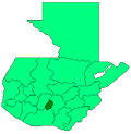
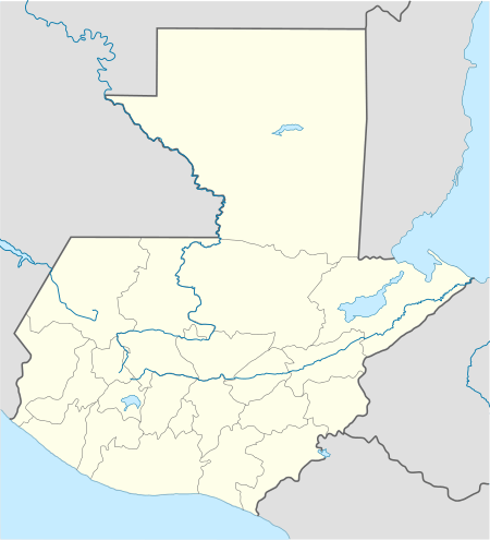 San Bartolomé Milpas Altas Location within Guatemala | |
| Coordinates: 14°36′26″N 90°40′41″W | |
| Country | |
| Department | |
| Foundation | Unknown |
| Government | |
| • Type | Municipality[1] |
| • Mayor (2016-2020) | Rosalío Aspuac Martínez (LIDER) |
| Area | |
| • Municipality | 5.18 km2 (2.00 sq mi) |
| • Urban | 5.18 km2 (2.00 sq mi) |
| Elevation | 2,090 m (6,860 ft) |
| Population (2018 census)[2] | |
| • Municipality | 7,816 |
| • Density | 1,500/km2 (3,900/sq mi) |
| • Urban | 7,816 |
| Time zone | UTC-6 (Central America) |
| Climate | Cwb |
History
In the 1540s, bishop Francisco Marroquín split the ecclesiastical administration of the central valley of Guatemala between the Order of Preachers and the Franciscans, assigning Sumpango's curato to the former.[3] In 1638, the Dominicans separated their large doctrines in groups revolving around six convents:
| Convent | Doctrines or curatos | Convent | Doctrines or curatos |
|---|---|---|---|
| Guatemala |
|
Amatitlán | |
| Verapaz |
| ||
| Sonsonate |
| ||
| San Salvador |
|
Sacapulas |
Ecclesiastic historian Domingo Juarros wrote that in 1754, by virtue of a royal order of the borbon reforms of king Carlos III all curatos and doctrines of the regular clergy were moved on to the secular clergy.[5]
Climate
San Bartolomé Milpas Altas has temperate climate (Köppen: Cwb).
| Climate data for San Bartolomé Milpas Altas | |||||||||||||
|---|---|---|---|---|---|---|---|---|---|---|---|---|---|
| Month | Jan | Feb | Mar | Apr | May | Jun | Jul | Aug | Sep | Oct | Nov | Dec | Year |
| Average high °C (°F) | 19.5 (67.1) |
20.6 (69.1) |
21.9 (71.4) |
22.8 (73.0) |
21.9 (71.4) |
20.4 (68.7) |
20.4 (68.7) |
21.0 (69.8) |
20.2 (68.4) |
19.7 (67.5) |
19.6 (67.3) |
19.6 (67.3) |
20.6 (69.1) |
| Daily mean °C (°F) | 14.1 (57.4) |
14.8 (58.6) |
15.9 (60.6) |
17.0 (62.6) |
17.1 (62.8) |
16.5 (61.7) |
16.2 (61.2) |
16.4 (61.5) |
16.0 (60.8) |
15.6 (60.1) |
14.8 (58.6) |
14.3 (57.7) |
15.7 (60.3) |
| Average low °C (°F) | 8.7 (47.7) |
9.0 (48.2) |
10.0 (50.0) |
11.3 (52.3) |
12.3 (54.1) |
12.6 (54.7) |
12.1 (53.8) |
11.8 (53.2) |
11.9 (53.4) |
11.5 (52.7) |
10.1 (50.2) |
9.1 (48.4) |
10.9 (51.6) |
| Average precipitation mm (inches) | 7 (0.3) |
6 (0.2) |
7 (0.3) |
42 (1.7) |
140 (5.5) |
301 (11.9) |
233 (9.2) |
212 (8.3) |
277 (10.9) |
154 (6.1) |
39 (1.5) |
11 (0.4) |
1,429 (56.3) |
| Source: Climate-Data.org[6] | |||||||||||||
See also

- List of places in Guatemala
Places adjacent to San Bartolomé Milpas Altas | ||||||||||
|---|---|---|---|---|---|---|---|---|---|---|
| ||||||||||
Notes and references
References
- "Alcaldes electos en el departamento de Sacatepéquez". Municipalidades de Guatemala (in Spanish). Guatemala. 8 September 2015. Archived from the original on October 28, 2015. Retrieved 28 October 2015.CS1 maint: ref=harv (link)
- Citypopulation.de Population of departments and municipalities in Guatemala!
- Juarros 1818, p. 336.
- Belaubre 2001, p. 39.
- Juarros 1818, p. 338.
- "Climate: San Bartolomé Milpas Altas". Climate-Data.org. Retrieved 19 August 2015.
- SEGEPLAN. "Municipios de Sacatepéquez, Guatemala". Secretaría de Planificación y Programación de la Presidencia (in Spanish). Guatemala. Archived from the original on 29 June 2015. Retrieved 29 June 2015.CS1 maint: ref=harv (link)
Bibliography
- Belaubre, Christopohe (2001). "Poder y redes sociales en Centroamérica: el caso de la Orden de los Dominicos (1757-1829)" (PDF). Mesoamérica (in Spanish). 41. Archived from the original (PDF) on 21 January 2015.CS1 maint: ref=harv (link)
- Cortés y Larraz, Pedro (2001) [1770]. García, Jesús María; Blasco, Julio Martín (eds.). Descripción Geográfico-Moral de la Diócesis de Goathemala. Corpus Hispanorum de Pace. Segunda Serie (in Spanish). Consejo Superior de Investigaciones Científicas. ISBN 9788400080013. ISSN 0589-8056.CS1 maint: ref=harv (link)
- Escalante Herrera, Marco Antonio (2007). "Breve información del municipio de San Bartolomé Milpas Altas". Pbase (in Spanish). Guatemala. Archived from the original on July 10, 2010. Retrieved 28 October 2015.CS1 maint: ref=harv (link)
- Fuentes y Guzmán, Francisco Antonio de (1883) [1690]. Zaragoza, Justo; Navarro, Luis (eds.). Recordación Florida. Discurso historial y demostración natural, material, militar y política del Reyno de Guatemala (in Spanish). II. Madrid, Spain: Central.CS1 maint: ref=harv (link)
- Juarros, Domingo (1818). Compendio de la historia de la Ciudad de Guatemala (in Spanish). Guatemala: Ignacio Beteta.CS1 maint: ref=harv (link)
- van Oss, Adriaan C. (1986). Catholic Colonialism: A Parish History of Guatemala, 1524-1821. Cambridge, UK: Cambridge University Press. ISBN 9780521527125.CS1 maint: ref=harv (link)
This article is issued from Wikipedia. The text is licensed under Creative Commons - Attribution - Sharealike. Additional terms may apply for the media files.