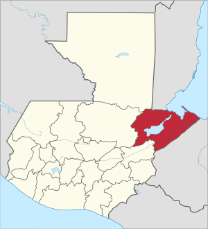
Izabal Department
Izabal (Spanish pronunciation: [isaˈβal]) is one of the 22 departments of Guatemala. Its coastal areas form part of the homeland of the Garifuna people.
Izabal Department Departmento de Izabal | |
|---|---|
.png) Flag  Coat of arms | |
 Izabal | |
| Coordinates: 15°44′0″N 88°36′0″W | |
| Country | |
| Capital | Puerto Barrios |
| Municipalities | 5 |
| Government | |
| • Type | Departmental |
| Area | |
| • Department of Guatemala | 9,038 km2 (3,490 sq mi) |
| • Water | 590 km2 (230 sq mi) |
| Population (2018)[1] | |
| • Department of Guatemala | 408,688 |
| • Density | 45/km2 (120/sq mi) |
| • Urban | 167,653 |
| • Ethnicities | Ladino, Q'eqchi', Garífuna, Afro-Caribbean |
| • Religions | Roman Catholicism, Evangelicalism, Maya |
| Time zone | UTC-6 |
| ISO 3166 code | GT-IZ |
Izabal is bordered to the north by Belize, to the north east by the Gulf of Honduras, and to the east by Honduras, and by the Guatemalan departments of Petén to the north west, Alta Verapaz to the west, and Zacapa to the south.
The Izabal Department surrounds Lake Izabal (or Lago de Izabal), Guatemala's largest lake (about 48 km long and 24 km wide, with an area of about 590 km²). The Spanish Colonial fort of San Felipe, now a Guatemalan national monument, overlooks the point where the lake flows into the Río Dulce.
The small town of Izabal is on the south shore of the lake; before the construction of the ports of Livingston and Puerto Barrios in the 19th century this was Guatemala's main Caribbean Sea port and was the original seat of Izabal department; nowadays, however, Izabal town is a remote village that gets little traffic.
From the area around Lake Izabal, the Department of Izabal stretches along the Río Dulce to the coast of the Caribbean Sea.
The department of Izabal includes the ports of Puerto Barrios (the departmental seat), Santo Tomás de Castilla, Livingston and Guatemala's free trade zone Zolic. Izabal also includes the Pre-Columbian Maya ruins of Quirigua.
Municipalities
- El Estor
- Livingston
- Los Amates
- Morales
- Puerto Barrios
See also

- Carlos Manuel Arana Osorio
- EXMIBAL
- Franja Transversal del Norte
- Jacobo Árbenz Guzmán
- José María Orellana
- Puerto Barrios
- Quiriguá
- Rafael Carrera
- Santo Tomás de Castilla
- United Fruit Company
Places adjacent to Izabal Department | |
|---|---|
References
- Citypopulation.de Population of departments in Guatemala
- SEGEPLAN. "Municipios de Izabal, Guatemala". Secretaría General de Planificación. Archived from the original on 5 July 2015. Retrieved 5 July 2015.CS1 maint: ref=harv (link)
External links
Capital: Puerto Barrios | ||
| Municipalities | 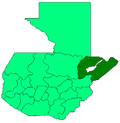 | |
Flag of Guatemala | ||
| Departaments in the region |
| |
|---|---|---|
| Major rivers and lakes |
| |
| International corporation in the area | ||
| Civil War events |
| |
| Presidents of Guatemala related to the region | ||