Ruisseau-Ferguson, Quebec
Ruisseau-Ferguson is an unorganized territory in the Gaspésie–Îles-de-la-Madeleine region of Quebec, Canada.
Ruisseau-Ferguson | |
|---|---|
Unorganized territory | |
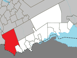 Location within Avignon RCM | |
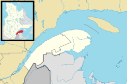 Ruisseau-Ferguson Location in eastern Quebec | |
| Coordinates: 48°05′N 67°30′W[1] | |
| Country | |
| Province | |
| Region | Gaspésie– Îles-de-la-Madeleine |
| RCM | Avignon |
| Constituted | unspecified |
| Government | |
| • Federal riding | Gaspésie— Îles-de-la-Madeleine |
| • Prov. riding | Bonaventure |
| Area | |
| • Total | 672.80 km2 (259.77 sq mi) |
| • Land | 680.07 km2 (262.58 sq mi) |
| There is an apparent contradiction between two authoritative sources | |
| Population (2011)[3] | |
| • Total | 0 |
| • Density | 0.0/km2 (0/sq mi) |
| • Pop 2006-2011 | |
| • Dwellings | 0 |
| Time zone | UTC-5 (EST) |
| • Summer (DST) | UTC-4 (EDT) |
| Highways | No major routes |
It is named after the Ferguson Creek that is a left tributary of the Restigouche River. The territory's western boundary is the Patapédia River.
Demographics
Population
| Historical Census Data - Ruisseau-Ferguson, Quebec[4] | ||||||||||||||||||||||||||
|---|---|---|---|---|---|---|---|---|---|---|---|---|---|---|---|---|---|---|---|---|---|---|---|---|---|---|
|
|
| ||||||||||||||||||||||||
References
- "Fiche descriptive". www.toponymie.gouv.qc.ca (in French). Retrieved 30 May 2012.
- "Ruisseau-Ferguson - Répertoire des municipalités - MAMROT". www.mamrot.gouv.qc.ca. Archived from the original on 1 May 2012. Retrieved 12 January 2012.
- "Statistics Canada: 2011 Census Profile". 2011 Census data. Statistics Canada. Retrieved 12 January 2012.
- Statistics Canada: 1996, 2001, 2006, 2011 census
Adjacent Municipal Subdivisions | |
|---|---|
| Cities & Towns | |
|---|---|
| Municipalities |
|
| Townships | |
| Unorganized Territories | |
| |
This article is issued from Wikipedia. The text is licensed under Creative Commons - Attribution - Sharealike. Additional terms may apply for the media files.