Rubirizi District
Rubirizi District is a district in Western Uganda. Like most Ugandan districts, the district is named after its 'chief town', Rubirizi, where the district headquarters are located.[1]
Rubirizi District | |
|---|---|
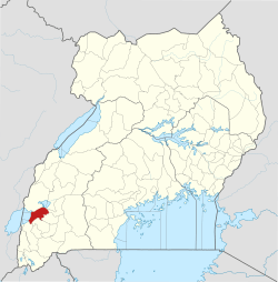 District location in Uganda | |
| Coordinates: 00°16′S 30°06′E | |
| Country | |
| Region | Western Uganda |
| Sub-region | Ankole sub-region |
| Capital | Rubirizi |
| Area | |
| • Land | 985 km2 (380 sq mi) |
| Elevation | 1,764 m (5,787 ft) |
| Population (2014 Census) | |
| • Total | 129,149 |
| • Density | 143.6/km2 (372/sq mi) |
| Time zone | UTC+3 (EAT) |
| Website | www |
Location
Rubirizi District is bordered by Kasese District to the north, Kamwenge District to the northeast, Ibanda District to the east, Buhweju District to the southeast, Bushenyi District to the south, Rukungiri District to the southwest and the Democratic Republic of the Congo to the west. The district headquarters at Rubirizi are located approximately 98 kilometres (61 mi), by road, northwest of Mbarara, the largest city in Ankole sub-region.[2] The coordinates of the district are: 00 16S, 30 06E.[3]
Overview
Rubirizi District was carved out of Bushenyi District in July 2010. Prior to then, the district was known as Bunyaruguru County.[4]
It is one of the districts that constitute Ankole sub-region, home to an estimated 3.9 million Banyankole, in 2018, according to CIA Factbook. The full list of districts in the sub-region include: 1. Buhweju District 2. Bushenyi District 3. Ibanda District 4. Isingiro District 5. Kiruhura District 6. Mitooma District 7. Ntungamo District 8. Rubirizi District 9. Sheema District
About 50% of Queen Elizabeth National Park lies in Rubirizi District. The key tourist areas of the park found in the district include:
- The Kyambura Gorge
- Parts of Lake Edward and Lake George
- The Kazinga Channel connects Lake Edward and Lake George and is popular for the boat ride.
- Over 50 crater lakes.[5]
Population
In 1991, the national population census estimated the district population at about 75,400. The national census in 2002 estimated the population in the district at about 101,800. The Rubirizi District population was enumerated at 129,149 in 2014.[6]
See also
References
- Rubirizi District (2019). "Rubirizi District: Overview". Rubirizi District. Retrieved 26 March 2019.
- Globefeed.com (26 March 2016). "Distance between Mbarara Post Office, Uganda and Rubirizi, Uganda". Globefeed.com. Retrieved 26 March 2019.
- Google (26 March 2019). "Location of Rubirizi District, Western Region, Uganda" (Map). Google Maps. Google. Retrieved 26 March 2019.
- Newvision Archives/Vision Reporters (22 April 2010). "Government Names 14 New Districts". New Vision. Archived from the original (Archived from he original on 29 October 2013) on 29 October 2013. Retrieved 26 March 2019.
- Rubirizi District (4 June 2018). "Rubirizi District Is Nature's Paradise". Rubirizi District. Retrieved 26 March 2019.
- Citypopulation.de (11 March 2019). "The population development of Rubirizi District". Citypopulation.de. Retrieved 26 March 2019.