Roxbury, New Jersey
Roxbury is a township in Morris County, New Jersey, United States. As of the 2010 United States Census, the township's population was 23,324,[9][10][11] reflecting a decline of 559 (-2.3%) from the 23,883 counted in the 2000 Census, which had in turn increased by 3,454 (+16.9%) from the 20,429 counted in the 1990 Census.[19] It is located approximately 36 miles (58 km) west-northwest of New York City, 27 miles (43 km) west-northwest of Newark, New Jersey and 26 miles (42 km) east of the Delaware Water Gap on the border of New Jersey and Pennsylvania.
Roxbury, New Jersey | |
|---|---|
| Township of Roxbury | |
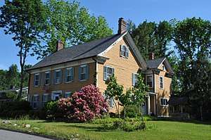 The Cary Station is listed on the U.S. National Register of Historic Places | |
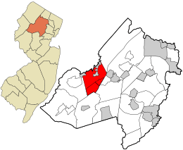 Location in Morris County and the state of New Jersey. | |
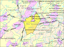 Census Bureau map of Roxbury Township, New Jersey | |
| Coordinates: 40.888304°N 74.650869°W[1][2] | |
| Country | |
| State | |
| County | Morris |
| Established | December 24, 1740 |
| Incorporated | February 21, 1798 |
| Government | |
| • Type | Faulkner Act (Council-Manager) |
| • Body | Township Council |
| • Mayor | Robert DeFilippo (R, term ends December 31, 2020)[4][5] |
| • Manager | John Shepherd [6] |
| • Municipal clerk | Amy Rhead[7] |
| Area | |
| • Total | 21.888 sq mi (56.691 km2) |
| • Land | 20.827 sq mi (53.942 km2) |
| • Water | 1.061 sq mi (2.749 km2) 4.85% |
| Area rank | 128th of 566 in state 7th of 39 in county[1] |
| Elevation | 837 ft (255 m) |
| Population | |
| • Total | 23,324 |
| • Estimate (2019)[12] | 22,551 |
| • Rank | 107th of 566 in state 5th of 39 in county[13] |
| • Density | 1,119.9/sq mi (432.4/km2) |
| • Density rank | 367th of 566 in state 27th of 39 in county[13] |
| Time zone | UTC−05:00 (Eastern (EST)) |
| • Summer (DST) | UTC−04:00 (Eastern (EDT)) |
| ZIP Code | |
| Area code(s) | 973[15] |
| FIPS code | 3402764980[1][16][17] |
| GNIS feature ID | 0882203[1][18] |
| Website | roxburynj |
History
Roxbury was formed on December 24, 1740, from portions of Morris Township.[20] It was formally incorporated by the Township Act of 1798 of the New Jersey Legislature on February 21, 1798, as part of the state's initial group of 104 townships. Portions of the township were taken to form Mendham Township (March 29, 1749), Washington Township (April 2, 1798), Chester Township (April 1, 1799), Jefferson Township (February 11, 1804), Mount Olive Township (March 22, 1871), Mount Arlington (November 3, 1890) and Netcong (October 23, 1894).[21]
Tom's Diner was featured in the music video from Time After Time by Cyndi Lauper.[22]
Geography
According to the United States Census Bureau, the township had a total area of 21.888 square miles (56.691 km2), including 20.827 square miles (53.942 km2) of land and 1.061 square miles (2.749 km2) of water (4.85%).[1][2]
Kenvil (2010 Census population of 3,009[23]) and Succasunna (2010 Census population of 9,152[24]) are unincorporated communities and census-designated places (CDPs)located within the township.[25][26][27] As of the 2000 United States Census, the two CDPs were consolidated as Succasunna-Kenvil,[27] which had a 2000 Census population of 12,569.[28]
Other unincorporated communities, localities and place names located partially or completely within the township include Baker Mill Pond, Berkshire Valley, Bertrand Island, Carys, Lake Hopatcong, Lake Junction, Lake Rogerene, Landing, Ledgewood, Port Morris, Port Morris Landing, Rustic and Shippenport.[29]
Roxbury borders the municipalities of Chester Township, Jefferson Township, Mine Hill Township, Mount Arlington, Mount Olive Township, Netcong, Randolph Township, Wharton in Morris County; and both Hopatcong and Stanhope in Sussex County.[30][31][32]
Demographics
| Historical population | |||
|---|---|---|---|
| Census | Pop. | %± | |
| 1810 | 1,563 | * | — |
| 1820 | 1,792 | 14.7% | |
| 1830 | 2,262 | 26.2% | |
| 1840 | 2,231 | −1.4% | |
| 1850 | 2,269 | 1.7% | |
| 1860 | 2,865 | 26.3% | |
| 1870 | 3,320 | 15.9% | |
| 1880 | 2,139 | * | −35.6% |
| 1890 | 2,739 | 28.1% | |
| 1900 | 2,185 | * | −20.2% |
| 1910 | 2,414 | 10.5% | |
| 1920 | 2,976 | 23.3% | |
| 1930 | 3,879 | 30.3% | |
| 1940 | 4,455 | 14.8% | |
| 1950 | 5,707 | 28.1% | |
| 1960 | 9,983 | 74.9% | |
| 1970 | 15,754 | 57.8% | |
| 1980 | 18,878 | 19.8% | |
| 1990 | 20,429 | 8.2% | |
| 2000 | 23,883 | 16.9% | |
| 2010 | 23,324 | −2.3% | |
| Est. 2019 | 22,551 | [12][33][34] | −3.3% |
| Population sources: 1810-1920[35] 1840[36] 1850-1870[37] 1850[38] 1870[39] 1880-1890[40] 1890-1910[41] 1910-1930[42] 1930-1990[43] 2000[44][45] 2010[9][10][11] * = Lost territory in previous decade.[21] | |||
2010 Census
The 2010 United States Census counted 23,324 people, 8,292 households, and 6,484.344 families in the township. The population density was 1,119.9 per square mile (432.4/km2). There were 8,582 housing units at an average density of 412.1 per square mile (159.1/km2). The racial makeup of the township was 88.21% (20,573) White, 2.34% (546) Black or African American, 0.09% (22) Native American, 5.77% (1,346) Asian, 0.05% (12) Pacific Islander, 1.55% (362) from other races, and 1.99% (463) from two or more races. Hispanic or Latino of any race were 8.93% (2,083) of the population.[9]
The 8,292 households accounted 36.0% with children under the age of 18 living with them; 65.6% were married couples living together; 9.3% had a female householder with no husband present, and 21.8% were non-families. Of all households, 18.2% were made up of individuals, and 8.0% had someone living alone who was 65 years of age or older. The average household size was 2.80 and the average family size was 3.19.[9]
In the township, the population age was spread out with 24.6% under the age of 18, 6.8% from 18 to 24, 23.6% from 25 to 44, 32.4% from 45 to 64, and 12.6% who were 65 years of age or older. The median age was 41.9 years. For every 100 females, the population had 95.8 males. For every 100 females ages 18 and older there were 92.5 males.[9]
The Census Bureau's 2006-2010 American Community Survey showed that (in 2010 inflation-adjusted dollars) median household income was $95,676 (with a margin of error of +/- $5,626) and the median family income was $110,538 (+/- $6,156). Males had a median income of $75,417 (+/- $7,299) versus $47,556 (+/- $4,775) for females. The per capita income for the borough was $38,576 (+/- $2,305). About 2.5% of families and 3.6% of the population were below the poverty line, including 4.0% of those under age 18 and 5.2% of those age 65 or over.[46]
2000 Census
As of the 2000 United States Census[16] there were 23,883 people, 8,364 households, and 6,532 families residing in the township. The population density was 1,117.4 people per square mile (431.5/km2). There were 8,550 housing units at an average density of 400.0 per square mile (154.5/km2). The racial makeup of the township was 92.57% White, 1.91% Black or African American, 0.15% Native American, 3.58% Asian, 0.07% Pacific Islander, 0.68% from other races, and 1.04% from two or more races. 4.83% of the population were Hispanic or Latino of any race.[44][45]
There were 8,364 households out of which 39.7% had children under the age of 18 living with them, 66.8% were married couples living together, 8.7% had a female householder with no husband present, and 21.9% were non-families. 17.9% of all households were made up of individuals and 6.5% had someone living alone who was 65 years of age or older. The average household size was 2.84 and the average family size was 3.25.[44][45]
In the township the population was spread out with 27.0% under the age of 18, 6.1% from 18 to 24, 31.4% from 25 to 44, 25.7% from 45 to 64, and 9.9% who were 65 years of age or older. The median age was 38 years. For every 100 females, there were 95.6 males. For every 100 females age 18 and over, there were 92.0 males.[44][45]
The median income for a household in the township was $72,982, and the median income for a family was $83,409. Males had a median income of $59,488 versus $36,353 for females. The per capita income for the township was $30,174. About 2.1% of families and 2.7% of the population were below the poverty line, including 2.2% of those under age 18 and 3.1% of those age 65 or over.[44][45]
Crime
According to the 2008 New Jersey State Police Uniform Crime Report, crime had declined in Roxbury versus 2007 data.[47] There was an uptick in crime for 2009.
| Population | Violent crime | Murder and non-negligent man-slaughter | Forcible rape | Robbery | Aggravated assault | Property crime | Burglary | Larceny-theft | Motor vehicle theft | Arson |
|---|---|---|---|---|---|---|---|---|---|---|
| 23,311 | 17 | 0 | 3 | 3 | 11 | 299 | 56 | 230 | 13 | 0 |
Economy
Ledgewood Mall (with a gross leasable area of 518,246 square feet (48,146.6 m2)[48]) and Roxbury Mall (with a GLA of 706,000 square feet (65,600 m2)[49]) are regional shopping malls located within the township.
Government
Local government
Roxbury operates under the Council-Manager form of Government under the Faulkner Act. The township is one of 42 of 565 municipalities statewide that use this form of government.[50] The Township Council is comprised of seven elected officials. Council members are elected for four-year terms on a staggered basis in partisan elections held in odd-numbered years, with three at-large seats selected together and one seat from each of four wards elected two years later. The mayor and deputy mayor are chosen from within the council by the members of the council at a reorganization meeting held each year during the first week in January to serve one-year terms of office.[3] The manager is responsible for the day-to-day operations associated with all municipal activities. The manager directs, administers and coordinates the activities of the municipality in full support of policies, goals and objectives established by the governing body.
As of 2020, the members of Roxbury's Township Council are Mayor Robert DeFillippo (R, term on council ends December 31, 2021 / term as mayor ends 2020; at large), Deputy Mayor Fred Hall (R, term on council ends 2023 / term as deputy mayor ends 2020; Ward 3), Jacqueline "Jaki" Albrect (R, 2023; Ward 2), Tom Carey (R, 2023; Ward 4), Mark Crowley (R, 2021; at large), Jim Rilee (R, 2021; at large) and Richard Zoschak (R, 2023; Ward 1).[4][51][52][53][54][55][56]
Roxbury Mount Arlington Study Commission
In March 2014, members of the public petitioned the New Jersey Department of Community Affairs to form the Roxbury Mount Arlington Study Commission to consider a possible consolidation of Roxbury and the neighboring municipality of Mount Arlington. In March 2015, the commission was formed with five members and two alternates from each municipality. If the commission votes to recommend a merger, the decision would have to be ratified by a referendum of the voters in each community.[57]
Federal, state and county representation
Roxbury is located in the 7th Congressional District[58] and is part of New Jersey's 25th state legislative district.[10][59][60] Prior to the 2010 Census, Roxbury had been part of the 11th Congressional District, a change made by the New Jersey Redistricting Commission that took effect in January 2013, based on the results of the November 2012 general elections.[61]
For the 116th United States Congress. New Jersey's Seventh Congressional District is represented by Tom Malinowski (D, Ringoes).[62] New Jersey is represented in the United States Senate by Democrats Cory Booker (Newark, term ends 2021)[63] and Bob Menendez (Paramus, term ends 2025).[64][65]
For the 2020–2021 session (Senate, General Assembly), the 25th Legislative District of the New Jersey Legislature is represented in the State Senate by Tony Bucco (R, Boonton Township) and in the General Assembly by Brian Bergen (R, Denville) and Aura K. Dunn (R, Mendham Borough).[66][67]
Senator Anthony R. Bucco died in September 2019. A special convention of the Republican County Committee members from the district met on October 15, 2019, and unanimously selected his son, Assemblyman Anthony M. Bucco to fill his father's seat until a 2020 special election. Assemblyman Bucco then resigned from the Assembly and on October 24, 2019, was sworn into the Senate. In a special convention following the 2019 General Election, Dunn was slected and will serve until the end of the current Legislative Session, January 14, 2020.[68]
Morris County is governed by a seven-member Board of Chosen Freeholders, who are elected at-large in partisan elections, to three-year terms on a staggered basis, with either one or three seats up for election each year as part of the November general election. The Freeholder Board sets policies for the operation of six super-departments, more than 30 divisions plus authorities, commissions, boards and study committees.[69] Actual day-to-day operation of departments is supervised by County Administrator, John Bonanni.[70] As of 2020, Morris County's Freeholders are Freeholder Director Deborah Smith (R, Denville, 2021),[71] Deputy Freeholder Director Stephen H. Shaw (R, Mountain Lakes, 2021),[72] Tayfun Selen (R, Chatham Township, 2020),[73] John Krickus (R, Washington Township, 2021),[74] Douglas Cabana (R, Boonton Township, 2022),[75] Kathryn A. DeFillippo (R, Roxbury, 2022),[76] and Thomas J. Mastrangelo (R, Montville, 2022).[77][78]
Tayfun Selen was elected by a county Republican convention to the vacant seat of Heather Darling, who was elected Morris County Surrogate in 2019. He will serve the remainder of her term which ends in 2020.[79]
Pursuant to Article VII Section II of the New Jersey State Constitution, each county in New Jersey is required to have three elected administrative officials known as "constitutional officers." These officers are the County Clerk and County Surrogate (both elected for five-year terms of office) and the County Sheriff (elected for a three-year term).[80] As of 2020, they are County Clerk Ann F. Grossi (R, Parsippany, 2023),[81] Sheriff James M. Gannon (R, Boonton Township, 2022)[82] and Surrogate Heather Darling (R, Roxbury, 2024).[83]
Politics
As of March 23, 2011, there were a total of 15,471 registered voters in Roxbury, of which 3,010 (19.5%) were registered as Democrats, 5,307 (34.3%) were registered as Republicans and 7,145 (46.2%) were registered as Unaffiliated. There were 9 voters registered to other parties.[84]
In the 2012 presidential election, Republican Mitt Romney received 59.9% of the vote (6,536 cast), ahead of Democrat Barack Obama with 39.2% (4,282 votes), and other candidates with 0.9% (100 votes), among the 10,996 ballots cast by the township's 16,262 registered voters (78 ballots were spoiled), for a turnout of 67.6%.[85][86] In the 2008 presidential election, Republican John McCain received 58.3% of the vote (7,182 cast), ahead of Democrat Barack Obama with 40.2% (4,952 votes) and other candidates with 0.9% (112 votes), among the 12,321 ballots cast by the township's 15,934 registered voters, for a turnout of 77.3%.[87] In the 2004 presidential election, Republican George W. Bush received 61.5% of the vote (7,270 ballots cast), outpolling Democrat John Kerry with 37.3% (4,411 votes) and other candidates with 0.7% (113 votes), among the 11,816 ballots cast by the township's 15,469 registered voters, for a turnout percentage of 76.4.[88]
In the 2013 gubernatorial election, Republican Chris Christie received 69.9% of the vote (4,996 cast), ahead of Democrat Barbara Buono with 27.9% (1,996 votes), and other candidates with 2.2% (154 votes), among the 7,267 ballots cast by the township's 16,060 registered voters (121 ballots were spoiled), for a turnout of 45.2%.[89][90] In the 2009 gubernatorial election, Republican Chris Christie received 65.3% of the vote (5,306 ballots cast), ahead of Democrat Jon Corzine with 25.6% (2,081 votes), Independent Chris Daggett with 8.0% (646 votes) and other candidates with 0.6% (45 votes), among the 8,120 ballots cast by the township's 15,686 registered voters, yielding a 51.8% turnout.[91]
Education
The Roxbury School District serves public school students in kindergarten through twelfth grade.[92] As of the 2018–19 school year, the district, comprised of seven schools, had an enrollment of 3,551 students and 328.1 classroom teachers (on an FTE basis), for a student–teacher ratio of 10.8:1.[93] Schools in the district consists of the following (with 2018–19 enrollment data from the National Center for Education Statistics[94]) are Franklin Elementary School[95] with 332 students in grades K-4, Jefferson Elementary School[96] with 369 students in grades K-4, Kennedy Elementary School[97] with 254 students in grades K-4, Nixon Elementary School[98] with 258 students in grades K-4, Lincoln / Roosevelt School[99] with 480 students in grades 5-6, Eisenhower Middle School[100] with 534 students in grades 7-8 and Roxbury High School[101] with 1,297 students in grades 9-12.[102][103]
The district's high school serves students from Roxbury, as well as Mount Arlington, who attend as part of a sending/receiving relationship with the Mount Arlington School District.[104]
Established in 1963, St. Therese School is a Catholic school operated under the auspices of the Roman Catholic Diocese of Paterson.[105][106]
Transportation
Roads and highways
As of May 2010, the township had a total of 133.66 miles (215.10 km) of roadways, of which 107.03 miles (172.25 km) were maintained by the municipality, 13.91 miles (22.39 km) by Morris County and 12.72 miles (20.47 km) by the New Jersey Department of Transportation.[107]
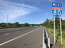
Interstate 80, U.S. Route 46, U.S. Route 206, Route 10 and Route 183 all pass through the township.
Public transportation
The NJ Transit Lake Hopatcong station[108] is served by the Morristown Line[109] and the Montclair-Boonton Line,[110] with service to Hoboken Terminal or to Pennsylvania Station in Midtown Manhattan via Midtown Direct which requires a transfer at Dover or Montclair State University.
Morristown & Erie Railway's Chester Branch and High Bridge Branch freight lines run through the township on weekdays.[111]
Port Morris was the starting point for the Lackawanna Cut-Off, an engineering marvel constructed by the Delaware, Lackawanna and Western Railroad between 1908–1911. NJ Transit is considering plans to restore passenger service on the route between the Pocono Mountains in Pennsylvania and Hoboken Terminal.[112]
NJ Transit provides limited local bus service on the 875 route between the Ledgewood Mall, Dover and Morristown.[113][114]
Lakeland Bus Lines stops in the Landing section of the township providing service to and from the Port Authority Bus Terminal in Midtown Manhattan.[115]
Notable people
People who were born in, residents of, or otherwise closely associated with Roxbury include:
- Trevor Baptiste (born 1996), professional lacrosse midfielder for the Boston Cannons.[116]
- Dylan Castanheira (born 1995), soccer player who plays as a goalkeeper for Fort Lauderdale CF in USL League One.[117]
- Harry "A" Chesler (1898-1981), entrepreneur behind the first comic book "packager" of the late-1930s to 1940s Golden Age of Comic Books, supplying comics features and complete comic books to publishers testing the waters of the emerging medium.[118]
- BettyLou DeCroce (born 1952), politician who has served in the New Jersey General Assembly since 2012, where she has represented the 26th Legislative District after being appointed to fill the seat following the death of her husband, Alex DeCroce.[119]
- Philemon Dickerson (1788-1862), 12th Governor of New Jersey.[120]
- Leo Warren Jenkins (1913–1989), educator who served as the sixth president and chancellor of what is now East Carolina University.[121]
- Doug Miller (born 1969), soccer player and coach.[122]
- Paige Monaghan (born 1996), professional soccer player who currently plays for Sky Blue FC of the National Women's Soccer League.[123]
- Dave Moore (born 1969), football player who played for the Buffalo Bills, Miami Dolphins and Tampa Bay Buccaneers.[124]
- Karen Ann Quinlan (1954-1985), important figure in the history of the right to die controversy in the United States.[125]
- Jetur R. Riggs (1809-1869), represented New Jersey's 4th congressional district in the U.S. Representative from 1859–1861.[126]
- Tito Santana (born 1953) former WWF wrestler.[127]
References
- 2010 Census Gazetteer Files: New Jersey County Subdivisions, United States Census Bureau. Accessed May 21, 2015.
- US Gazetteer files: 2010, 2000, and 1990, United States Census Bureau. Accessed September 4, 2014.
- 2012 New Jersey Legislative District Data Book, Rutgers University Edward J. Bloustein School of Planning and Public Policy, March 2013, p. 116.
- Elected Officials, Roxbury Township. Accessed March 4, 2020.
- 2020 New Jersey Mayors Directory, New Jersey Department of Community Affairs. Accessed February 1, 2020. As of date accessed, DeFilippo is listed with a term-end year of 2021, which is the end of his four-year council term, not his one-year mayoral term.
- Township Manager's Office, Township of Roxbury. Accessed March 4, 2020.
- Clerk's Office, Township of Roxbury. Accessed March 4, 2020.
- U.S. Geological Survey Geographic Names Information System: Township of Roxbury, Geographic Names Information System. Accessed March 11, 2013.
- DP-1 - Profile of General Population and Housing Characteristics: 2010 Demographic Profile Data for Roxbury township, Morris County, New Jersey Archived February 12, 2020, at Archive.today, United States Census Bureau. Accessed May 7, 2012.
- Municipalities Sorted by 2011-2020 Legislative District, New Jersey Department of State. Accessed February 1, 2020.
- Profile of General Demographic Characteristics: 2010 for Roxbury township Archived June 5, 2015, at the Wayback Machine, New Jersey Department of Labor and Workforce Development. Accessed May 7, 2012.
- QuickFacts for Roxbury township, Morris County, New Jersey; Morris County, New Jersey; New Jersey from Population estimates, July 1, 2019, (V2019), United States Census Bureau. Accessed May 21, 2020.
- GCT-PH1 Population, Housing Units, Area, and Density: 2010 - State -- County Subdivision from the 2010 Census Summary File 1 for New Jersey Archived February 12, 2020, at Archive.today, United States Census Bureau. Accessed December 22, 2012.
- Look Up a ZIP Code for Ledgewood, NJ, United States Postal Service. Accessed May 7, 2012.
- Area Code Lookup - NPA NXX for Roxbury Township, NJ, Area-Codes.com. Accessed January 21, 2015.
- U.S. Census website , United States Census Bureau. Accessed September 4, 2014.
- Geographic codes for New Jersey, Missouri Census Data Center. Accessed September 1, 2019.
- US Board on Geographic Names, United States Geological Survey. Accessed September 4, 2014.
- Table 7. Population for the Counties and Municipalities in New Jersey: 1990, 2000 and 2010, New Jersey Department of Labor and Workforce Development, February 2011. Accessed December 22, 2012.
- Historical Timeline of Morris County Boundaries, Morris County Library. Accessed December 24, 2016. "1740, December 24. Roxbury is established. Roxbury includes Kenvil (previously known as McCainsville), Landing (previously known as Drakesville), Ledgewood, Port Morris, and Suckasunny/Succasunna (its name is changed in 1888)."
- Snyder, John P. The Story of New Jersey's Civil Boundaries: 1606-1968, Bureau of Geology and Topography; Trenton, New Jersey; 1969. p. 197. Accessed May 7, 2012.
- Conson, Mike. "Once an iconic landmark, Tom's Diner now an eyesore in Roxbury", Roxbury Register, August 18, 2011. Accessed May 7, 2012. "Everybody in Morris County knows 'Tom's Diner.' In the 1980's, it was the shooting location for pop star Cyndi Lauper's Time After Time video."
- DP-1 - Profile of General Population and Housing Characteristics: 2010 Demographic Profile Data for Kenvil CDP, New Jersey Archived February 12, 2020, at Archive.today, United States Census Bureau. Accessed May 7, 2012.
- DP-1 - Profile of General Population and Housing Characteristics: 2010 Demographic Profile Data for Succasunna CDP, New Jersey Archived February 12, 2020, at Archive.today, United States Census Bureau. Accessed May 7, 2012.
- GCT-PH1 - Population, Housing Units, Area, and Density: 2010 - County -- County Subdivision and Place from the 2010 Census Summary File 1 for Morris County, New Jersey Archived February 12, 2020, at Archive.today, United States Census Bureau. Accessed December 22, 2012.
- 2006-2010 American Community Survey Geography for New Jersey, United States Census Bureau. Accessed December 22, 2012.
- New Jersey: 2010 - Population and Housing Unit Counts - 2010 Census of Population and Housing (CPH-2-32), United States Census Bureau, August 2012. Accessed December 22, 2012.
- DP-1: Profile of General Demographic Characteristics: Census 2000 Summary File 1 (SF 1) 100-Percent Data for Succasunna-Kenvil CDP, New Jersey , United States Census Bureau. Accessed May 7, 2012.
- Locality Search, State of New Jersey. Accessed May 21, 2015.
- Areas touching Roxbury Township, MapIt. Accessed March 4, 2020.
- Morris County Municipalities Map, Morris County, New Jersey Department of Planning and Preservation. Accessed March 4, 2020.
- New Jersey Municipal Boundaries, New Jersey Department of Transportation. Accessed November 15, 2019.
- Annual Estimates of the Resident Population for Minor Civil Divisions in New Jersey: April 1, 2010 to July 1, 2019, United States Census Bureau. Accessed May 21, 2020.
- Census Estimates for New Jersey April 1, 2010 to July 1, 2019, United States Census Bureau. Accessed May 21, 2020.
- Compendium of censuses 1726-1905: together with the tabulated returns of 1905, New Jersey Department of State, 1906. Accessed July 18, 2013.
- Bowen, Francis. American Almanac and Repository of Useful Knowledge for the Year 1843, p. 231, David H. Williams, 1842. Accessed July 18, 2013.
- Raum, John O. The History of New Jersey: From Its Earliest Settlement to the Present Time, Volume 1, p. 269, J. E. Potter and company, 1877. Accessed December 22, 2012. "Roxbury contained in 1850 2,269 inhabitants; in 1860, 2,865; and in 1870, 3,320."
- Debow, James Dunwoody Brownson. The Seventh Census of the United States: 1850, p. 140. R. Armstrong, 1853. Accessed December 22, 2012.
- Staff. A compendium of the ninth census, 1870, p. 260. United States Census Bureau, 1872. Accessed December 22, 2012.
- Porter, Robert Percival. Preliminary Results as Contained in the Eleventh Census Bulletins: Volume III - 51 to 75, p. 99. United States Census Bureau, 1890. Accessed December 22, 2012.
- Thirteenth Census of the United States, 1910: Population by Counties and Minor Civil Divisions, 1910, 1900, 1890, United States Census Bureau, p. 338. Accessed December 22, 2012.
- "Fifteenth Census of the United States: 1930 - Population Volume I", United States Census Bureau, p. 717. Accessed December 22, 2012.
- Table 6. New Jersey Resident Population by Municipality: 1930 - 1990, New Jersey Department of Labor and Workforce Development. Accessed June 28, 2015.
- Census 2000 Profiles of Demographic / Social / Economic / Housing Characteristics for Roxbury township, New Jersey Archived June 5, 2015, at the Wayback Machine, United States Census Bureau. Accessed May 7, 2012.
- DP-1: Profile of General Demographic Characteristics: 2000 - Census 2000 Summary File 1 (SF 1) 100-Percent Data for Roxbury township, Morris County, New Jersey Archived February 12, 2020, at Archive.today, United States Census Bureau. Accessed December 22, 2012.
- DP03: Selected Economic Characteristics from the 2006-2010 American Community Survey 5-Year Estimates for Roxbury township, Morris County, New Jersey Archived February 12, 2020, at Archive.today, United States Census Bureau. Accessed May 7, 2012.
- New Jersey Municipal-County Offense & Demographic Data, New Jersey State Police. Accessed May 7, 2012.
- Directory of Major Malls: Ledgewood Mall Archived March 4, 2008, at the Wayback Machine, International Council of Shopping Centers. Accessed May 7, 2012.
- Directory of Major Malls: Roxbury Mall Archived March 13, 2007, at the Wayback Machine, International Council of Shopping Centers. Accessed May 7, 2012.
- Inventory of Municipal Forms of Government in New Jersey, Rutgers University Center for Government Studies, July 1, 2011. Accessed November 18, 2019.
- 2019 Municipal User Friendly Budget, Roxbury Township. Accessed March 4, 2020.
- Morris County Manual 2020, Morris County, New Jersey Clerk. Accessed June 3, 2020.
- Morris County Municipal Elected Officials For The Year 2020, Morris County, New Jersey Clerk, updated March 17, 2020. Accessed June 3, 2020.
- General Election November 5, 2019, Official Results, Morris County, New Jersey, updated November 15, 2019. Accessed January 31, 2020.
- General Election Winners List For November 6, 2018, Morris County, New Jersey Clerk. Accessed January 1, 2019.
- General Election November 7, 2017 Official Results, Morris County, New Jersey Clerk, updated November 17, 2017. Accessed January 1, 2018.
- Westhoven, William. "Roxbury-Mt. Arlington consolidation commission named", Daily Record (Morristown), March 30, 2015. "The public is about to get its first chance to meet the chosen members of the Roxbury Mount Arlington Study Commission and discuss the dominant topic on its agenda — a possible consolidation of the neighboring municipalities."
- Plan Components Report, New Jersey Redistricting Commission, December 23, 2011. Accessed February 1, 2020.
- 2019 New Jersey Citizen's Guide to Government, New Jersey League of Women Voters. Accessed October 30, 2019.
- Districts by Number for 2011-2020, New Jersey Legislature. Accessed January 6, 2013.
- 2011 New Jersey Citizen's Guide to Government Archived June 4, 2013, at the Wayback Machine, p. 64, New Jersey League of Women Voters. Accessed May 22, 2015.
- Directory of Representatives: New Jersey, United States House of Representatives. Accessed June 1, 2020.
- About Cory Booker, United States Senate. Accessed January 26, 2015. "He now owns a home and lives in Newark's Central Ward community."
- Biography of Bob Menendez, United States Senate, January 26, 2015. "He currently lives in Paramus and has two children, Alicia and Robert."
- Senators of the 116th Congress from New Jersey. United States Senate. Accessed April 17, 2019. "Booker, Cory A. - (D - NJ) Class II; Menendez, Robert - (D - NJ) Class I"
- Legislative Roster 2020-2021 Session, New Jersey Legislature. Accessed February 28, 2020.
- District 25 Legislators, New Jersey Legislature. Accessed February 28, 2020.
- Pizarro, Max. "Dunn Sworn into the Assembly", Insider NJ, November 25, 2019. Accessed November 25, 2019. "Speaker Craig Coughlin (D-19) this afternoon administered the office to Assemblywoman Aura Dunn (R-25), who last week at a special convention formally landed the seat left behind by Senator Tony Bucco (R-25)."
- Freeholder's Job, Morris County, New Jersey. Accessed April 16, 2019.
- Morris County Manual 2019, Morris County Clerk. Accessed April 16, 2019.
- Deborah Smith, Morris County, New Jersey. Accessed May 12, 2020.
- Stephen H. Shaw, Morris County, New Jersey. Accessed May 12, 2020.
- Tayfun Selen, Morris County, New Jersey. Accessed May 12, 2020, 2019.
- John Krickus, Morris County, New Jersey. Accessed May 12, 2020.
- Douglas R. Cabana, Morris County, New Jersey. Accessed May 12, 2020).
- Kathryn A. DeFillippo, Morris County, New Jersey. Accessed May 12, 2020.
- Thomas J. Mastrangelo, Morris County, New Jersey. Accessed May 12, 2020.
- Freeholders, Morris County, New Jersey. Accessed May 12, 2020.
- Filler, Marion. "Morris County's next freeholder is…Tayfun Selen". Morristown Green. Retrieved May 12, 2020.
- New Jersey State Constitution (1947), Article VII, Section II, Paragraph 2, New Jersey Department of State. Accessed October 26, 2017.
- Ann F. Grossi, Esq., Office of the Morris County Clerk. Accessed April 16, 2019.
- About Us: Sheriff James M. Gannon, Morris County Sheriff's Office. Accessed April 16, 2019.
- Morris County Surrogate Court, Morris County, New Jersey. Accessed May 12, 2020.
- Voter Registration Summary - Morris, New Jersey Department of State Division of Elections, March 23, 2011. Accessed December 22, 2012.
- "Presidential General Election Results - November 6, 2012 - Morris County" (PDF). New Jersey Department of Elections. March 15, 2013. Retrieved December 24, 2014.
- "Number of Registered Voters and Ballots Cast - November 6, 2012 - General Election Results - Morris County" (PDF). New Jersey Department of Elections. March 15, 2013. Retrieved December 24, 2014.
- 2008 Presidential General Election Results: Morris County, New Jersey Department of State Division of Elections, December 23, 2008. Accessed December 22, 2012.
- 2004 Presidential Election: Morris County, New Jersey Department of State Division of Elections, December 13, 2004. Accessed December 22, 2012.
- "Governor - Morris County" (PDF). New Jersey Department of Elections. January 29, 2014. Retrieved December 24, 2014.
- "Number of Registered Voters and Ballots Cast - November 5, 2013 - General Election Results - Morris County" (PDF). New Jersey Department of Elections. January 29, 2014. Retrieved December 24, 2014.
- 2009 Governor: Morris County Archived October 17, 2012, at the Wayback Machine, New Jersey Department of State Division of Elections, December 31, 2009. Accessed December 22, 2012.
- Roxbury Township Board of Education District Policy 0110 - Identification, Roxbury School District. Accessed June 13, 2020. "Purpose: The Board of Education exists for the purpose of providing a thorough and efficient system of free public education in grades Pre-Kindergarten through twelve in the Roxbury Township School District. Composition: The Roxbury Township School District is comprised of all the area within the municipal boundaries of Roxbury Township."
- District information for Roxbury Township School District, National Center for Education Statistics. Accessed April 1, 2020.
- School Data for Roxbury School District, National Center for Education Statistics. Accessed April 1, 2020.
- Franklin Elementary School, Roxbury School District. Accessed June 13, 2020.
- Jefferson Elementary School, Roxbury School District. Accessed June 13, 2020.
- Kennedy Elementary School, Roxbury School District. Accessed June 13, 2020.
- Nixon Elementary School, Roxbury School District. Accessed June 13, 2020.
- Lincoln / Roosevelt School, Roxbury School District. Accessed June 13, 2020.
- Eisenhower Middle School, Roxbury School District. Accessed June 13, 2020.
- Roxbury High School, Roxbury School District. Accessed June 13, 2020.
- School Directory, Roxbury School District. Accessed June 13, 2020.
- New Jersey School Directory for the Roxbury School District, New Jersey Department of Education. Accessed December 7, 2016.
- O'Dea, Colleen. "State orders impact study of school regionalization", Daily Record (Morristown), November 23, 2008. Accessed January 30, 2011. "Mount Arlington, K-8, sends its high school students to Roxbury, K-12."
- Morris County, Roman Catholic Diocese of Paterson Catholic Schools Office. Accessed September 26, 2015.
- History, St. Therese School. Accessed August 25, 2013.
- Morris County Mileage by Municipality and Jurisdiction, New Jersey Department of Transportation, May 2010. Accessed July 24, 2014.
- Lake Hopatcong station, NJ Transit. Accessed August 4, 2014.
- Morristown Line, NJ Transit. Accessed August 4, 2014.
- Montclair-Boonton Line, NJ Transit. Accessed August 4, 2014.
- Rehabilitation of Roxbury Rail Line Complete, Morris County, New Jersey, May 17, 2011. Accessed December 31, 2016. "The Chester Branch connects to the High Bridge Branch, and these two lines connect to the NJ Transit line near the Roxbury – Rockaway Township border, allowing businesses along these branches to connect to the national rail freight network."
- Lackawanna Cutoff, NJ Transit. Accessed May 7, 2012.
- Morris County Bus / Rail Connections, NJ Transit, backed up by the Internet Archive as of May 22, 2009. Accessed December 22, 2012.
- Morris County System Map, NJ Transit. Accessed August 5, 2015.
- Route 80 - Eastbound to New York, Lakeland Bus Lines. Accessed June 25, 2017.
- Havsy, Jane. "Morristown-Beard alumnus Trevor Baptiste picked No. 1 in Major League Lacrosse draft", Daily Record (Morristown), April 18, 2018. Accessed September 9, 2018. "Baptiste, a Morristown-Beard alumnus who grew up in Roxbury and Denville, was picked first overall by the Boston Cannons on Wednesday night."
- Havsy, Jane for the Daily Record (Morristown). "Roxbury alum Dylan Castanheira now Atlanta United II goalkeeper", Milwaukee Journal Sentinel, June 6, 2019. Accessed June 12, 2020. "Columbia senior goalkeeper Dylan Castanheira of Landing signed with Atlanta United 2 on Friday.... After missing his freshman season at Roxbury High School due to a twice-broken leg, Castanheira was able to train with Stoke City in England for a week in the summer and was invited to return for a more formal tryout a couple of months later."
- Ewing, Emma Mai. "The 'Funnies' Can be Serious", The New York Times, September 12, 1976. Accessed August 24, 2018. "Now, however thanks to Harry "A" Chesler of Succasunna, all that is changing at Fairleigh Dickinson University in madison, where students and teachers are studying comics and cartoons as related to the transition of American society."
- Assemblywoman BettyLou DeCroce, New Jersey Legislature. Accessed September 26, 2015.
- Philemon Dickerson, Biographical Directory of the United States Congress. Accessed August 25, 2013. "Dickerson, Philemon, (brother of Mahlon Dickerson), a Representative from New Jersey; born in Succasunna, Morris County, N.J., January 11, 1788"
- Session 1989 House Joint Resolution 459 - A Joint Resolution Honoring The Life And Memory Of Dr. Leo Warren Jenkins, Former Chancellor Of East Carolina University, North Carolina General Assembly, March 6, 1989. Accessed June 12, 2020. "Whereas, Leo Warren Jenkins was born on May 28, 1913, in Succasunna, New Jersey and was raised in Elizabeth, New Jersey"
- About Founder of DMS, Doug Miller Soccer. Accessed June 25, 2017.
- Havsy, Jane. "Roxbury alumna Paige Monaghan signs with Sky Blue FC", Daily Record, February 4, 2019. Accessed June 12, 2020. "Butler midfielder Paige Monaghan, a Roxbury graduate, was recently named to the Big East first team.... 'I am beyond blessed to have been drafted and now signed with Sky Blue FC,' Monaghan, a 22-year-old from Succasunna, said in a press release."
- Kitchin, Mark. "Roxbury's Moore retires from NFL", Daily Record (Morristown), June 8, 2007. Accessed May 7, 2012. "Roxbury native Dave Moore retired on Thursday after a 15-year NFL career as a tight end and long snapper, primarily with the Tampa Bay Buccaneers..."
- McFadden, Robert D. "Karen Ann Quinlan, 31, Dies; Focus Of '76 Right To Die Case", The New York Times, June 12, 1985. Accessed September 26, 2015. "Four weeks after her birth, the Quinlans took out adoption papers and took her home to their two-story gray-and-white colonial-style house at 510 Ryerson Road in the Landing section of Roxbury Township, just above Lake Hopatcong in Morris County."
- Jetur Rose Riggs, Biographical Directory of the United States Congress. Accessed September 2, 2007.
- Lusardi, Anthony. "Roxbury's Tito Santana enjoys the quieter life", Roxbury Register, August 6, 2013. Accessed June 30, 2015. "'I like being home most of the time. Wrestling was good to me while it lasted, but it was time for me to get out,' said Santana, who has called the Ledgewood section of the township home for years."
External links
| Wikimedia Commons has media related to Roxbury Township, New Jersey. |
- Township website
- Roxbury School District
- Roxbury School District's 2015–16 School Report Card from the New Jersey Department of Education
- School Data for the Roxbury School District, National Center for Education Statistics
- History of Roxbury, New Jersey
Municipalities and communities of Morris County, New Jersey, United States | ||
|---|---|---|
| Boroughs |  Map of New Jersey highlighting Morris County | |
| Towns | ||
| Townships | ||
| CDPs | ||
| Other unincorporated communities |
| |
Places adjacent to Roxbury, New Jersey | |
|---|---|