Rockdale Township, Crawford County, Pennsylvania
Rockdale Township is a township in Crawford County, Pennsylvania, United States. The population was 1,506 at the 2010 census.[4]
Rockdale Township, Crawford County, Pennsylvania | |
|---|---|
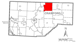 Location of Rockdale Township in Crawford County | |
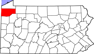 Location of Crawford County in Pennsylvania | |
| Country | United States |
| State | Pennsylvania |
| County | Crawford County |
| Area | |
| • Total | 36.21 sq mi (93.79 km2) |
| • Land | 36.03 sq mi (93.33 km2) |
| • Water | 0.18 sq mi (0.47 km2) |
| Highest elevation [2] (northwest of Sturgis Corners and Brown Hill) | 1,650 ft (500 m) |
| Lowest elevation [2] (French Creek) | 1,130 ft (340 m) |
| Population (2010) | |
| • Total | 1,506 |
| • Estimate (2018)[3] | 1,442 |
| • Density | 40.68/sq mi (15.71/km2) |
| Time zone | UTC-4 (EST) |
| • Summer (DST) | UTC-5 (EDT) |
| Area code(s) | 814 |
History
The Bridge in Rockdale Township was listed on the National Register of Historic Places in 1988.[5]
Geography
Rockdale Township is located along the northern edge of Crawford County, with Erie County to the north. According to the United States Census Bureau, the township has a total area of 36.2 square miles (93.8 km2), of which 36.0 square miles (93.3 km2) is land and 0.2 square miles (0.5 km2), or 0.50%, is water.[4]
Demographics
| Historical population | |||
|---|---|---|---|
| Census | Pop. | %± | |
| 2000 | 1,343 | — | |
| 2010 | 1,506 | 12.1% | |
| Est. 2018 | 1,442 | [3] | −4.2% |
| U.S. Decennial Census[6] | |||
As of the census[7] of 2000, there were 1,343 people, 454 households, and 349 families residing in the township. The population density was 37.3 people per square mile (14.4/km²). There were 576 housing units at an average density of 16.0/sq mi (6.2/km²). The racial makeup of the township was 98.36% White, 0.45% African American, 0.07% Native American, 0.45% Asian, and 0.67% from two or more races. Hispanic or Latino of any race were 0.15% of the population.
There were 454 households, out of which 41.6% had children under the age of 18 living with them, 64.8% were married couples living together, 6.8% had a female householder with no husband present, and 23.1% were non-families. 18.7% of all households were made up of individuals, and 7.0% had someone living alone who was 65 years of age or older. The average household size was 2.96 and the average family size was 3.39.
In the township the population was spread out, with 33.4% under the age of 18, 6.7% from 18 to 24, 28.3% from 25 to 44, 22.9% from 45 to 64, and 8.8% who were 65 years of age or older. The median age was 33 years. For every 100 females, there were 108.9 males. For every 100 females age 18 and over, there were 100.2 males.
The median income for a household in the township was $40,887, and the median income for a family was $42,067. Males had a median income of $36,989 versus $23,382 for females. The per capita income for the township was $15,071. About 12.3% of families and 16.5% of the population were below the poverty line, including 21.9% of those under age 18 and 13.9% of those age 65 or over.
Notable people
- Silas U. Pinney, Wisconsin jurist and politician
References
- "2016 U.S. Gazetteer Files". United States Census Bureau. Retrieved Aug 13, 2017.
- "Forest Home Corners Topo Map, Crawford County PA (Millers Station Area)". TopoZone. Locality, LLC. Retrieved 2 September 2019.
- Bureau, U. S. Census. "U.S. Census website". United States Census Bureau. US Census Bureau. Retrieved 18 July 2019.
- "Geographic Identifiers: 2010 Census Summary File 1 (G001): Rockdale township, Crawford County, Pennsylvania". U.S. Census Bureau, American Factfinder. Archived from the original on February 13, 2020. Retrieved June 9, 2015.
- "National Register Information System". National Register of Historic Places. National Park Service. July 9, 2010.
- "Census of Population and Housing". Census.gov. Retrieved June 4, 2016.
- "U.S. Census website". United States Census Bureau. Retrieved 2008-01-31.
Municipalities and communities of Crawford County, Pennsylvania, United States | ||
|---|---|---|
| Cities | | |
| Boroughs | ||
| Townships |
| |
| CDPs | ||
| Unincorporated communities | ||