Rožaje Municipality
Rožaje Municipality is one of the municipalities of Montenegro. The center is Rožaje. It covers an area of 432 km2, and had a population of 22,964 at the 2011 Census. It is located in the geographical region of Sandžak.
Rožaje Municipality Opština Rožaje Komuna e Rozhajës | |
|---|---|
 Coat of arms | |
 Rožaje Municipality in Montenegro | |
| Coordinates: 42.8333°N 20.1667°E | |
| Country | Montenegro |
| Capital | Rožaje |
| Number of settlements | 66 (58 rural, 8 urban) |
| Area | |
| • Total | 432 km2 (167 sq mi) |
| Population (2011 Census) | |
| • Total | 22,964 |
| • Density | 53/km2 (140/sq mi) |
| Postal code | 84310 |
| Area code | +382 51 |
| ISO 3166 code | ME-17 |
| Vehicle registration | RO |
| Website | www |
Geography and location
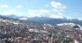
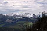
Rožaje municipality is located the mountainous region northeastern region of Montenegro. Rožaje spreads on the banks of Ibar river, near its source, at an altitude of 1000 meters. In the mountains surrounding the city are Beleg, Sijenova, Ahmica, Turjak, Vlahovi, Krsača, and above all of them rises 2,403 m high Hajla. Rožaje is situated on the main road connecting Montenegro with Kosovo. It also has a link with Novi Pazar in Central Serbia. The IB-22 Highway (otherwise known as the Ibarska magistrala) is the main regional road that connects Montenegro with Serbia.
Local parliament
| Parties and coalitions | Seats | Gov't. |
|---|---|---|
| Bosniak Party | 19 | Yes |
| Democratic Party of Socialists | 10 | No |
| Social Democrats | 4 | No |
| Social Democratic Party | 1 | No |
Demographics
Town Rožaje is the administrative centre of the Rožaje municipality, which has a total of 23,312 residents. The town of Rožaje itself has a population of 9,567 in 2011. Rožaje is also considered to be the centre for the Bosniak community of Montenegro. Bosniaks form the majority in both the town and the municipality itself. Ethnic Albanians have settled in the city. The current population of Albanians living in Rožaje rounds up to 1,158, forming 5% of the
total population in 2011.
|
Ethnic groups (2011):[1]
|
Languages (2011):
|
|