Pljevlja Municipality
Pljevlja Municipality is one of the municipalities of Montenegro. The municipality is located in northwestern region of Montenegro. Administrative center is Town of Pljevlja. It covers an area of 1,346 and had a population of 30,786 at the 2011 census.[1]
Pljevlja Municipality Opština Pljevlja | |
|---|---|
 Coat of arms | |
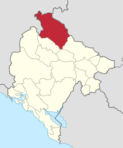 Pljevlja Municipality in Montenegro | |
| Country | Montenegro |
| Seat | Pljevlja |
| Area | |
| • Total | 1,346 km2 (520 sq mi) |
| Population (2011 Census) | |
| • Total | 30,786 |
| • Density | 23/km2 (59/sq mi) |
| Time zone | UTC+1 |
| • Summer (DST) | UTC+2 (CEST) |
| Area code | +382 52 |
| ISO 3166-2 code | ME-14 |
| Car plates | PV |
| Climate | Cfb |
| Website | http://www.pljevlja.me/ |
Geography and location
The municipality borders Žabljak Municipality, Bijelo Polje Municipality and Mojkovac Municipality in Montenegro, as well as the republics of Serbia and Bosnia and Herzegovina. With a total area of 1,346 km2 (520 sq mi), it is the third largest municipality in Montenegro.
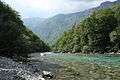
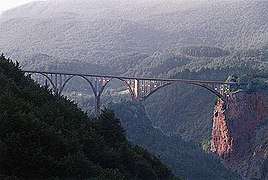
The highest point of the municipality is on the Ljubišnja mountain at an altitude of 2,238 m (7,343 ft), while the lowest point is in the canyon of the Tara river with an altitude of 529 m (1,736 ft) above sea level.
Demographics
Town of Pljevlja is the administrative center of Pljevlja municipality, which has a population of 35,806. The town of Pljevlja itself has 19,136 citizens, and is the only town in the municipality with a population of over 1,000. The municipality has a majority of Serbs. According to the 2011 census, the population consisted of: Serbs (60.11%), Montenegrins (21.52%), Muslims (8.14%) and Bosniaks (5.21%).[2]
Local parliament
| Parties and coalitions | Seats | Gov't. |
|---|---|---|
| DPS - SD - BS Coalition | 20 | Yes |
| Democratic Montenegro | 7 | No |
| NOVA - SNP - PzP Coalition | 4 | No |
| Democratic People's Party and True Montenegro | 4 | No |
Settlements
- Aliži
- Beljkovići
- Bjeloševina
- Bobovo
- Boljanići
- Borišići
- Borova
- Borovica
- Boščinovići
- Brda, Pljevlja
- Bujaci
- Bušnje
- Čardak, Pljevlja
- Čavanj
- Čerjenci
- Cerovci
- Čestin
- Crljenice
- Crni Vrh, Pljevlja
- Crno Brdo
- Crnobori
- Donja Brvenica
- Dragaši, Pljevlja
- Dubac
- Dubočica
- Dubrava, Pljevlja
- Đuli
- Đurđevića Tara
- Durutovići
- Dužice
- Geuši
- Glibaći
- Glisnica
- Gornja Brvenica
- Gornje Selo
- Gotovuša
- Gradac, Pljevlja
- Gradina, Pljevlja
- Grevo
- Horevina
- Hoćevina
- Jabuka, Pljevlja
- Jagodni Do
- Jahovići
- Jasen
- Jugovo
- Kakmuži
- Kalušići
- Katun, Pljevlja
- Klakorina
- Kolijevka
- Komine
- Kordovina
- Kosanica
- Kotlajići
- Kotline
- Kotorac
- Kovačevići
- Kovači, Pljevlja
- Kozica, Pljevlja
- Košare
- Krupice
- Kruševo, Pljevlja
- Krćevina
- Kržava
- Kukavica, Pljevlja
- Lađana
- Leovo Brdo
- Lever Tara
- Lijeska, Pljevlja
- Ljutići
- Ljuće
- Lugovi, Pljevlja
- Male Krće
- Maoče
- Mataruge
- Meljak
- Metaljka
- Mijakovići
- Milakovići
- Milunići
- Mironići
- Moraice
- Moćevići
- Mrzovići
- Mrčevo
- Mrčići
- Nange
- Obarde
- Odžak
- Ograđenica
- Orlja, Pljevlja
- Otilovići
- Pauče
- Petine
- Pižure
- Plakala
- Planjsko
- Pliješ
- Pliješevina
- Poblaće
- Podborova
- Popov Do
- Potkovač
- Potkrajci, Pljevlja
- Potoci, Pljevlja
- Potpeće, Pljevlja
- Potrlica
- Pračica
- Prehari
- Premćani
- Prisoji
- Prošće
- Pušanjski Do
- Rabitlje
- Rađevići
- Romac
- Rudnica, Pljevlja
- Rujevica, Pljevlja
- Selac
- Selišta, Pljevlja
- Sirčići
- Slatina, Pljevlja
- Šljivansko, Pljevlja
- Šljuke
- Srećanje
- Stančani
- Strahov Do
- Šula
- Šumani
- Tatarovina
- Trnovice
- Tvrdakovići
- Uremovići
- Varine
- Vaškovo
- Velike Krće
- Vidre, Pljevlja
- Vijenac
- Vilići
- Višnjica
- Vodno
- Vojtina
- Vrba, Pljevlja
- Vrbica, Pljevlja
- Vrulja
- Zabrđe, Pljevlja
- Zaselje, Pljevlja
- Zbljevo
- Zekavice
- Zenica, Pljevlja
- Židovići
- Zorlovići
Twin towns – sister cities
Gallery
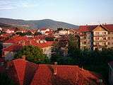 Town of Pljevlja
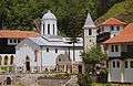
.jpg)
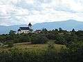 Church near Pljevlja
References
- Opštine, MJU, Vlada Crne Gore
- http://www.monstat.org/userfiles/file/popis2011/saopstenje/saopstenje%281%29.pdf
- "U Domu kulture obilježeno svečano otvaranje adaptiranih prostorija Muzeja, Biblioteke i Galerije". pljevlja.me (in Montenegrin). Pljevlja. 2019-11-19. Retrieved 2020-06-22.
| Capital City | ||
|---|---|---|
| Municipalities | ||