R560 road (Ireland)
The R560 road is a regional road in Ireland. It is a road on the Dingle Peninsula in County Kerry.[1][2] The road forms part of the Wild Atlantic Way.[3]
| ||||
|---|---|---|---|---|
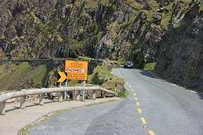 R560 at Connor Pass | ||||
| Route information | ||||
| Length | 31.9 km[1][2] (19.8 mi) | |||
| Major junctions | ||||
| From | ||||
| ||||
| To | ||||
| Road network | ||||
| ||||

The R560 travels southwest from the N86 near Camp via Connor Pass between the Brandon and central Dingle mountain groups. The pass summit, at an elevation of 460 m (1,500 ft), affords panoramic views of the Dingle area and Dingle Bay. From here, the road descends to end at Dingle.[4] The R560 is 31.9 km (19.8 mi) long.[1]
References
- Google (7 Jun 2016). "R560 to Spa Road" (Map). Google Maps. Google. Retrieved 7 Jun 2016.
- "S.I. No. 54/2012 – Roads Act 1993 (Classification of Regional Roads) Order 2012". Government of Ireland. 28 Feb 2012. Retrieved 7 Jun 2016.
- "Wild Atlantic Way: Explore The Route". Fáilte Ireland. Retrieved 7 Jun 2016.
- Poole, Susan; Gallagher, Lyn (2008). AA Best Drives Ireland. The Automobile Association. pp. 27–28. ISBN 978-0-7495-4430-0.
This article is issued from Wikipedia. The text is licensed under Creative Commons - Attribution - Sharealike. Additional terms may apply for the media files.