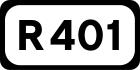
R401 road (Ireland)
The R401 road is a regional road in Ireland, linking Kinnegad in County Meath to Kildare town in County Kildare.
| |
|---|---|
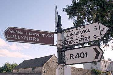 Old signs on the R401 in Rathangan show distances in miles and the old route number, "L18" | |
| Route information | |
| Length | 42.3 km (26.3 mi) |
| Location | |
| Primary destinations |
|
| Road network | |
The total length of the R401 is 42.3 kilometres (26.3 mi).
Route
The official description of the R401 from the Roads Act 1993 (Classification of Regional Roads) Order 2012 [1] reads:
- R401: Kinnegad, County Westmeath — Edenderry, County Offaly — Kildare
Between its junction with R148 at Rossan in the county of Meath and its junction with R402 at J.K.L. Street in the town of Edenderry in the county of Offaly via Park in the county of Meath: Ballyboggan Bridge at the boundary between the county of Meath and the county of Kildare: Glynn Cross and Ballygibbon in the county of Kildare: Carrick Road and Saint Conleths Road in the town of Edenderry in the county of Offaly (map of this 15.3 km segment) and between its junction with R402 at Saint Mary's Road in the town of Edenderry in the county of Offaly and its junction with R415 at Station Road in the town of Kildare in the county of Kildare via Drumcooly, Ballykilleen, Clonbullogue and Coolygagan in the county of Offaly: Ballysooghan North; Main Street and Bridge Street at Rathangan; Boherkill, Rahilla Glebe; Shraud and Bohereenagorr in the town of Kildare in the county of Kildare (map of this 27 km segment).