R584 road (Ireland)
The R584 road is a regional road in Ireland. It is a road in west County Cork.[1][2]
| ||||
|---|---|---|---|---|
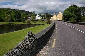 R584 at Ballingeary crossing River Lee | ||||
| Route information | ||||
| Length | 47.0 km[1][2] (29.2 mi) | |||
| Major junctions | ||||
| From | ||||
| ||||
| To | ||||
| Road network | ||||
| ||||

The R584 travels southwest from the N22 near Macroom via Ballingeary and following the course of the River Lee (including Lough Allua) to reach Gougane Barra.[1] Gougane Barra is a scenic area including a Forest Park and Gougane Lake, the source of the Lee.[3] The section of the road near Macroom provides access to The Gearagh, a River Lee nature reserve of rare alluvial forest, unique in Ireland.[4] From Gougane Barra, the road travels through the Pass of Keimaneigh[3] in the Shehy Mountains and onward to end at the N71 at Ballylickey. The R584 is 47.0 km (29.2 mi) long.[1]
References
- Google (6 Jun 2016). "R584 to N71" (Map). Google Maps. Google. Retrieved 6 Jun 2016.
- "S.I. No. 54/2012 – Roads Act 1993 (Classification of Regional Roads) Order 2012". Government of Ireland. 28 Feb 2012. Retrieved 6 Jun 2016.
- Poole, Susan; Gallagher, Lyn (2008). AA Best Drives Ireland. The Automobile Association. p. 53. ISBN 978-0-7495-4430-0.
- Doherty, Tony (11 Sep 2015). "A walk for the weekend: The Gearagh, Macroom, Co Cork". The Irish Times. Retrieved 6 Jun 2016.
This article is issued from Wikipedia. The text is licensed under Creative Commons - Attribution - Sharealike. Additional terms may apply for the media files.