Quilpie, Queensland
Quilpie (/ˈkwɪlpi/ KWIL-pee) is a rural town and locality in the Shire of Quilpie, Queensland, Australia.[2][3] In the 2016 census, Quilpie had a population of 595 people.[1]
| Quilpie Queensland | |||||||||||||||
|---|---|---|---|---|---|---|---|---|---|---|---|---|---|---|---|
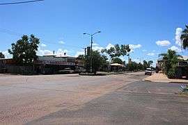 Brolga St, the main street of Quilpie | |||||||||||||||
 Quilpie | |||||||||||||||
| Coordinates | 26.6161°S 144.2675°E | ||||||||||||||
| Population | 595 (2016 census)[1] | ||||||||||||||
| • Density | 0.033339/km2 (0.08635/sq mi) | ||||||||||||||
| Established | 1917 | ||||||||||||||
| Postcode(s) | 4480 | ||||||||||||||
| Area | 17,847.0 km2 (6,890.8 sq mi) | ||||||||||||||
| Time zone | AEST (UTC+10:00) | ||||||||||||||
| Location |
| ||||||||||||||
| LGA(s) | Shire of Quilpie | ||||||||||||||
| State electorate(s) | Warrego | ||||||||||||||
| Federal Division(s) | Maranoa | ||||||||||||||
| |||||||||||||||
The town is the administrative centre of the Quilpie Shire local government area. The town of Toompine is also within the locality.
The economy of the area is based on the grazing and mining industries. The area has one of the largest deposits of boulder opal in the world, and also has extensive deposits of gas and oil.
Geography
Quilpie is in Channel Country on the banks of the Bulloo River. It is on the Diamantina Developmental Road, 208 kilometres (129 mi) west of Charleville, and 980 kilometres (610 mi) west of the state capital, Brisbane. Quilpie is the administrative centre of the Quilpie Shire.
The town of Toompine (27.2225°S 144.3611°E) is within the locality of Quilpie
Other townships in the shire include Adavale and Eromanga.
Quilpie has quite a few trees but sometime drought takes over and the landscape can become dry and desolate.
History
Quilpie is believed to lie on the border of the Bunthamurra and Margany Indigenous Australian tribal areas.[4]
Margany (also known as Marganj, Mardigan, Marukanji, Maranganji) is an Australian Aboriginal language spoken by the Margany people. The Margany language region includes the landscape within the local government boundaries of the Quilpie Shire, taking in Quilpie, Cheepie and Beechal extending towards Eulo and Thargomindah, as well as the properties of Dynevor Downs and Ardoch.[5]
Toompine Provisional School and Duck Creek Provisional School both opened in 1900. In 1901 they became half-time schools (meaning they shared a single teacher between the two schools). Toompine Provisional School closed in July 1902, enabling Duck Creek Provisional School to revert to full-time status. Due to low student numbers, Duck Creek Provisional School closed in 1905.[6]
Quilpie was gazetted as a town in 1917 owing to the Western railway line that was laid down from Brisbane.[7] It takes its name from the Indigenous Australian word for stone curlew, quilpeta.[2][3][8] The name was proposed by pastoralist James Hammond of Tenham Station.[2] The Queensland Railways Department mistakenly named the railway station Quillpill.[9] The town and station name were standardised to Quilpie on 16 June 1917 by the Governor in Council.[10][11]
Quilpie State School opened on 10 September 1918.[6] The school began offering secondary education in 1966. On 5 December 2008 it was renamed Quilpie State College.[12][13]
The first post office was opened in 1921. Two years later the telephone reached Quilpie .[14]
A fire destroyed a block of the main street in 1926. With no town water the residents watched helplessly.[14]
In 1927 the first court house was established.[14]
Prior to 1930, Quilpie was within the Shire of Adavale, headquartered at Adavale. However, the decision to route the railway line through Quilpie rather than Adavale had led to a population drift away from Adavale making Quilpie the larger town. On 17 July 1930, there was a re-organisation of local government in the district, resulting in the abolition of the Shire of Adavale and the creation of the Shire of Quilpie with Quilpie as its headquarters.[14]
A bore was sunk into the Great Artesian Basin in 1933. It provided drinking water for the town and for a period between 1952 and 1963 the hot water was used to generate electricity for the town.[14]
St Finbarr's Catholic School opened in early 1950, shortly after the arrival in January 1950 of three Sisters of St Joseph of the Sacred Heart, Sisters Macrina, Carmel and Magdalen. By the end of 1950, over 60 children were enrolled. A boarding school for boys and girls was opened in 1951. The first lay teacher, Michael West, was appointed in 1983. When the boarding facility closed in 2008, it was the last rural Catholic primary boarding school in Queensland. In 2009, the first lay principal, Aaron Wells, was appointed and the administration of the school passed from the Sisters to the Catholic Education Office of the Roman Catholic Diocese of Toowoomba who operate the school in the Mary MacKillop tradition (MacKillop being the founder of the Sisters of St Joseph).[6][15][16]
Goombie State School opened on Goombie Station (north of Quilpie at 26.1126°S 144.1348°E) on 27 January 1970 and closed on 9 December 1977.[6]
At the 2001 census Quilpie had a population of 645. Around 14% of the population of Quilpie identity as Aboriginal or Torres Strait Islander and around 2% were born outside Australia.[17]
The current Quilpie Public Library building opened in 2005.[18]
At the 2006 census Quilpie had a population of 560.[19]
At the 2011 census Quilpie had a population of 574 people.[20]
Economy
The area is wholly devoted to grazing. Boulder opal, oil and gas mining are major secondary industries for the local economy. The majority of the employees of these industries are local residents, with low rates of both unemployment and itinerant work.
Quilpie has one opal mining field; Toompine Field is located between Quilpie and Yowah.
Flora and fauna
The most common species of trees in the district are:[21]
There are a large range of animals (including reptiles and insects) that are can be found in the area including:
- Bearded dragon
- Sand goanna (Varanus gouldii) - bungarra in some aboriginal languages
- Black-headed python
- Inland taipan (Oxyuranus microlepidotus) - also known as western taipan and fierce snake
- Mulga snake (Pseudechis australis) - also known as the king brown
- Brolga (Grus rubicunda)
- Emu (Dromaius novaehollandiae)
- Wedge-tailed eagle (Aquila audax)
- Red kangaroo (Macropus rufus)
- Eastern grey kangaroo (Macropus giganteus)
- Common wallaroo (Macropus robustus)
- Bilby (Macrotis lagotis)
- Water rat (Hydromys chrysogaster)
- Dingo
Facilities and services
Quilpie residents enjoy free access to many amenities including the town library, swimming pool, golf course, museum, sports grounds, an air-conditioned hall and supper room etc. There are well stocked stores and plenty of attractions for visitors with displays of opals and the works of local artists and as well as an information centre. The Brick Hotel[22] has been restored to house displays of opal and art and provide a community learning space.[23]
Quilpie Shire Council operates Quilpie Shire Library, 52 Brolga Street, Quilpie.[24]
The Quilpie branch of the Queensland Country Women's Association has its rooms at 17 Brolga Street.[25]
Education
Quilpie State College is a government primary and secondary (Early Childhood-10) school for boys and girls at Cnr Chulungra & Boonkai Streets (26.6149°S 144.2714°E).[26][27] In 2017, the school had an enrolment of 61 students with 12 teachers (11 full-time equivalent) and 12 non-teaching staff (9 full-time equivalent).[28]
St Finbarr's School is a Catholic primary (Prep-6) school for boys and girls at Jabiru Street (26.6167°S 144.2701°E).[26][29] In 2017, the school had an enrolment of 30 students with 5 teachers (3 full-time equivalent) and 5 non-teaching staff (2 full-time equivalent).[28] Eromanga State School currently operates in the township of Eromanga approximately 90 km west of Quilpie. It has had a chequered history when it was open in the following years - 1897-1908, 1910-1911, 1917–1936, 1967-1981, 1990–present.
Many other public schools have operated in the Quilpie district. The Milo Provisional School was functional between 1888 and 1906. Adavale State School had a long history from 1888-1968. Cheepie State School opened in 1915 and closed in 1974. The Toompine Provisional School was open between 1900 and 1902, for a time operating as a half-time school with Duck Creek State School which was open between 1901 and 1905. The Goombie State School operated between 1875 and 1977.
Climate
Quilpie has a semi-arid climate with hot summers and mild, spring-like winters.
| Climate data for Quilpie | |||||||||||||
|---|---|---|---|---|---|---|---|---|---|---|---|---|---|
| Month | Jan | Feb | Mar | Apr | May | Jun | Jul | Aug | Sep | Oct | Nov | Dec | Year |
| Record high °C (°F) | 47.1 (116.8) |
45.5 (113.9) |
42.9 (109.2) |
38.4 (101.1) |
34.5 (94.1) |
32.1 (89.8) |
29.4 (84.9) |
37.0 (98.6) |
40.1 (104.2) |
43.8 (110.8) |
44.9 (112.8) |
46.1 (115.0) |
47.1 (116.8) |
| Average high °C (°F) | 37.0 (98.6) |
35.6 (96.1) |
33.4 (92.1) |
29.2 (84.6) |
24.0 (75.2) |
20.4 (68.7) |
20.1 (68.2) |
22.7 (72.9) |
27.1 (80.8) |
31.1 (88.0) |
34.0 (93.2) |
36.1 (97.0) |
29.2 (84.6) |
| Average low °C (°F) | 23.8 (74.8) |
23.3 (73.9) |
20.5 (68.9) |
15.7 (60.3) |
10.9 (51.6) |
7.4 (45.3) |
6.1 (43.0) |
7.7 (45.9) |
11.7 (53.1) |
16.1 (61.0) |
19.6 (67.3) |
22.2 (72.0) |
15.4 (59.7) |
| Record low °C (°F) | 13.7 (56.7) |
13.3 (55.9) |
9.6 (49.3) |
3.5 (38.3) |
1.0 (33.8) |
−1.2 (29.8) |
−2.3 (27.9) |
−1.0 (30.2) |
2.1 (35.8) |
5.4 (41.7) |
8.6 (47.5) |
12.3 (54.1) |
−2.3 (27.9) |
| Average precipitation mm (inches) | 52.6 (2.07) |
50.7 (2.00) |
43.3 (1.70) |
24.8 (0.98) |
26.9 (1.06) |
20.0 (0.79) |
16.7 (0.66) |
12.5 (0.49) |
14.0 (0.55) |
21.6 (0.85) |
30.9 (1.22) |
34.5 (1.36) |
348.7 (13.73) |
| Average precipitation days | 4.8 | 4.5 | 3.9 | 2.5 | 2.8 | 2.8 | 2.7 | 2.2 | 2.5 | 3.6 | 4.1 | 4.5 | 40.9 |
| Source: [30] | |||||||||||||
Events
Notable people from Quilpie
- Vaughan Johnson, Queensland state politician
- Ewen Jones, Australian federal politician
- Professor Don Markwell, social scientist and educational leader
- Sandy McPhie, former Queensland state politician
- Justine Saunders, late Australian actor
Gallery
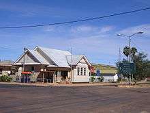 Quilpie Post Office in 2007
 Quilpie Visitors Centre and regional art gallery
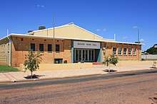 Quilpie Shire Hall
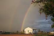 Rainbow over Quilpie - view from behind the Art Gallery
 Quilpie public art in the main street
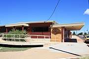 Quilpie Public Library
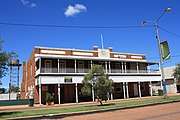 Quilpie Hotel
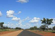 Development Road into Quilpie.
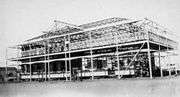 The Imperial Hotel under construction, c.1925
 A Brisbane tourist's car being trucked to Quilpie railhead, 1952
 Drinking at the bar of the Quilpie Hotel, c.1921
See also
References
- Australian Bureau of Statistics (27 June 2017). "Quilpie (SSC)". 2016 Census QuickStats. Retrieved 20 October 2018.

- "Quilpie - town in Shire of Quilpie (entry 27822)". Queensland Place Names. Queensland Government. Retrieved 30 November 2019.
- "Quilpie - locality in Shire of Quilpie (entry 50254)". Queensland Place Names. Queensland Government. Retrieved 30 November 2019.
- Jenkins, Lesley (January 2001). Lure of the Land: A Brief History of the Quilpie Shire (PDF). Archived (PDF) from the original on 26 March 2015. Retrieved 23 July 2014.
- "Margany". State Library of Queensland. Retrieved 15 January 2020.
- Queensland Family History Society (2010), Queensland schools past and present (Version 1.01 ed.), Queensland Family History Society, ISBN 978-1-921171-26-0
- "Walkabout - Quilpie". 8 June 2007. Archived from the original on 1 July 2017. Retrieved 11 November 2016.
- "Archived copy". Archived from the original on 6 October 2012. Retrieved 13 February 2012.CS1 maint: archived copy as title (link)
- "Quilpie - railway station in Shire of Quilpie (entry 27823)". Queensland Place Names. Queensland Government. Retrieved 1 January 2020.
- "Queensland Place Names". Department of Natural Resources and Mines. Archived from the original on 9 February 2018. Retrieved 21 April 2017.
- "WESTERN RAILWAY". Daily Mail (4422). Queensland, Australia. 1 May 1917. p. 4. Retrieved 21 April 2017 – via National Library of Australia.
- "School History". Quilpie State School. 20 June 2011. Archived from the original on 20 March 2012. Retrieved 15 March 2012.
- "Agency ID5641, Quilpie State School (College)". Queensland State Archives. Retrieved 1 January 2020.
- Environmental Protection Agency (Queensland) (2002). Heritage Trails of the Queensland Outback. State of Queensland. pp. 104–105. ISBN 0-7345-1040-3.
- "History". St Finbarr's, Quilpie. Archived from the original on 1 January 2020. Retrieved 1 January 2020.
- "NEWS FROM QUILPIE". The Charleville Times. Queensland, Australia. 6 July 1950. p. 10. Retrieved 2 January 2020 – via Trove.
- Australian Bureau of Statistics (9 March 2006). "Tambo (L) (Urban Centre/Locality)". 2001 Census QuickStats. Retrieved 15 March 2012.
- "Public Libraries Statistical Bulletin 2016-17" (PDF). Public Libraries Connect. November 2017. Archived (PDF) from the original on 30 January 2018. Retrieved 29 January 2018.
- Australian Bureau of Statistics (25 October 2007). "Quilpie (L) (Urban Centre/Locality)". 2006 Census QuickStats. Retrieved 21 July 2008.
- Australian Bureau of Statistics (31 October 2012). "Quilpie (SSC)". 2011 Census QuickStats. Retrieved 23 July 2014.
- Quilpie Shire Council, "Tracks and Facts of Quilpie Shire" 2011 p. 13
- "The pub with no beer". Archived from the original on 7 March 2016. Retrieved 1 January 2020.
- Community Learning Space Archived 29 September 2007 at the Wayback Machine
- "Quilpie Shire Library". Public Libraries Connect. State Library of Queensland. Archived from the original on 2 January 2018. Retrieved 23 January 2018.
- "Branch locations". Queensland Country Women's Association. Archived from the original on 26 December 2018. Retrieved 26 December 2018.
- "State and non-state school details". Queensland Government. 9 July 2018. Archived from the original on 21 November 2018. Retrieved 21 November 2018.
- "Quilpie State College". Archived from the original on 26 March 2012. Retrieved 21 November 2018.
- "ACARA School Profile 2017". Archived from the original on 22 November 2018. Retrieved 22 November 2018.
- "St Finbarr's School". Archived from the original on 10 December 2018. Retrieved 21 November 2018.
- "Climate statistics for Quilpie". Bureau of Meteorology. Archived from the original on 3 March 2016. Retrieved 1 April 2014.
- "Archived copy". Archived from the original on 8 August 2014. Retrieved 1 August 2014.CS1 maint: archived copy as title (link)
- "Archived copy". Archived from the original on 27 February 2015. Retrieved 4 June 2015.CS1 maint: archived copy as title (link)
- "Archived copy". Archived from the original on 5 February 2016. Retrieved 4 June 2015.CS1 maint: archived copy as title (link)
Further reading
- Jenkins, Lesley (January 2001). Lure of the Land: A Brief History of the Quilpie Shire (PDF).
External links
| Wikimedia Commons has media related to Quilpie, Queensland. |
- University of Queensland: Queensland Places: Quilpie and Quilpie Shire
- Official website of Shire of Quilpie
- Town map of Quilie, 1984
- Living in Quilpie by Ben Hall, a 3 min 20 sec video, published by State Library of Queensland as part of Storylines:Q150 digital stories
| Authority control |
|
|---|