Pulo, Cabuyao
Barangay Pulo (PSGC: 043404013) is one of the eighteen (18) urbanized[1] barangays comprising the city of Cabuyao in the province of Laguna, Philippines. It lies for about 3 kilometers away from the city proper of Cabuyao and is situated along the national highway. According to the 2010 Census,[2] it has a population of 15,124 inhabitants (grew from 13,193 in Census 2007[3]), making it ranked as the 6th largest barangay in Cabuyao when it comes to population.
Barangay Pulo City of Cabuyao | |
|---|---|
 | |
| Nickname(s): Nayon ng Pulo, Barrio Pulo | |
| Country | |
| Region | Calabarzon (Region IV-A) |
| Province | Laguna |
| City | Cabuyao |
| Incorporated (settlement) | 1571 |
| Government | |
| • Type | Sangguniang Barangay, with Chairman as its head supported by seven (7) Barangay Councilors |
| • Barangay Chairman | Armando H. Amoranto |
| Area | |
| • Industrial Barangay | 4.9 km2 (1.9 sq mi) |
| Population (May 2010) | |
| • Industrial Barangay | 15,124 |
| • Density | 3,100/km2 (8,000/sq mi) |
| • Urban | 15,124 |
| Time zone | UTC+8 (PST) |
| • Summer (DST) | Manila |
| Zip Code | 4025 |
| Area code(s) | 049 |
| Languages | Tagalog and English |
| Demonym | Puloeños |
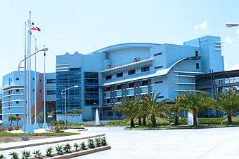
Malayan Colleges Laguna is located in Barangay Pulo. It also homes the Cabuyao Exit from the South Luzon Expressway or SLEx.
Geography
Land Area
The total land area of Barangay Pulo is 490 hectares (has.) or 4.9 square kilometers (km2), ranking second (2nd) out of eighteen (18) barangays in the city of Cabuyao when it comes to land area. It lies for about 3 kilometers (km) away from the town proper and is situated along the National Highway.[4]
Location
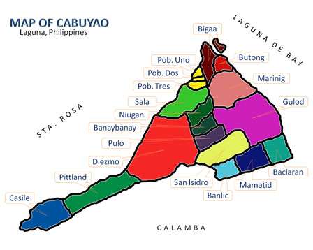
It is located north of Brgy. San Isidro, east of Brgy. Diezmo, south of Brgy. Banay-Banay and west of Brgy. Gulod in Cabuyao, Laguna.
It is also one of the six (6) barangays of the city along the National Highway while the others are Barangays Banlic, Banay-Banay, Niugan, Sala and San Isidro.[4]
Climate
Types of Seasons
The rainfall regime of Barangay Pulo is characterized by the two (2) pronounced seasons, the wet and dry seasons. The wet season which is from June to November and the relatively dry season that lasts from December to May. The average rainfall is about 2,000 mm of rain falling in an average year, there are about 150 days which are rainy days.[5]
Temperature
The seasonal variations of the Temperature field is uneventful. The coldest months start from November up to January and the warmest month on the record is the month of May. On the average, a 12 °C temperature difference exists between the warmest and coolest months. The mean annual temperature is a warm 27.5 °C.[5]
Humidity
The annual relative Humidity is 70%. The most humid months are June, July, August and September with the normal relative humidity registered at 84%, while April and May are the driest at 70%.[5]
Locators
- Ram Foods, Corp.
Demography
According to 2010 Census,[2] it has a population of 15,124 inhabitants, grew from 13,193 in Census 2007.[3]
| No. | Barangay | Rank | Population (2007) | Population (2010) | Population Density (2010) | Annual Growth Rate (Average) |
|---|---|---|---|---|---|---|
| 1 | Baclaran | 9th | 12,683 | 12,192 | 6,985/km2 | |
| 2 | Banay-Banay | 4th | 17,419 | 21,934 | 7.073/km2 | |
| 3 | Banlic | 7th | 9,707 | 12,675 | 5,511/km2 | |
| 4 | Bigaa | 10th | 8,649 | 10,051 | 4,807/km2 | |
| 5 | Butong | 8th | 12,274 | 12,360 | 7,630/km2 | |
| 6 | Casile | 16th | 1,555 | 2,128 | 669/km2 | |
| 7 | Diezmo | 15th | 2,689 | 2,681 | 1,686/km2 | |
| 8 | Gulod | 11th | 10,127 | 9,417 | 2,304/km2 | |
| 9 | Mamatid | 1st | 37,166 | 50,213 | 19,313/km2 | |
| 10 | Marinig | 2nd | 25,619 | 37,169 | 9,494/km2 | |
| 11 | Niugan | 3rd | 21,993 | 26,807 | 7,615/km2 | |
| 12 | Pittland | 18th | 1,627 | 1,740 | 598/km2 | |
| 13 | Pulo | 6th | 13,193 | 15,124 | 5,041/km2 | |
| 14 | Sala | 12th | 7,491 | 8,275 | 5,353/km2 | |
| 15 | San Isidro | 5th | 15,495 | 18,145 | 5,767/km2 | |
| 16 | Barangay I Poblacion | 14th | 2,589 | 2,839 | 12,334/km2 | |
| 17 | Barangay II Poblacion | 17th | 1,947 | 1,840 | 7,886/km2 | |
| 18 | Barangay III Poblacion | 13th | 3,153 | 2,846 | 12,034/km2 | |
| TOTAL | 6th | 205,376 | 248,436 | 5,700/km2 |
Barangay Officials (2017-2019)
Barangay Captain: Armando Amoranto
Mga Kagawad:
- Hon. Minerva O. Mampolino
- Hon. Yuki A. Buyo
- Hon. Michael L. Epino
- Hon. Zenaida L. Lopez
- Hon. Romualdo J. Diamante
- Hon. Onofre N. Ocumen
- Hon. Alberto P. Caparas
- Hon. Eugene Roi D. Ednalino
See also
- Cabuyao, Laguna
- Laguna, Philippines
- Malayan Colleges Laguna
References
- Philippine Standard Geographic Code
- "Final Results - 2010 Census of Population". census.gov.ph. Archived from the original on 2012-07-07. Retrieved 2012-06-16.
- 2007 Census table for Laguna Archived 2011-06-07 at the Wayback Machine - National Statistics Office
- Cabuyao, Laguna/Barangay Location Archived 2012-01-28 at the Wayback Machine
- Cabuyao, Laguna/Physical Characteristics Archived 2010-10-29 at the Wayback Machine
External links
Places adjacent to Pulo, Cabuyao | ||||||||||
|---|---|---|---|---|---|---|---|---|---|---|
| ||||||||||
| Geography |
|  | |||||||||
|---|---|---|---|---|---|---|---|---|---|---|---|
| City |
| ||||||||||
| Officials |
| ||||||||||
| History |
| ||||||||||
| Districts and Barangays |
| ||||||||||
| Notable people |
| ||||||||||
Barangays in italics are unofficial
| |||||||||||
| Geography |
| | |||||||||
|---|---|---|---|---|---|---|---|---|---|---|---|
| City |
| ||||||||||
| Officials |
| ||||||||||
| History |
| ||||||||||
| Districts and Barangays |
| ||||||||||
| Notable people |
| ||||||||||
Barangays in italics are unofficial
| |||||||||||