Prawet District
Prawet District (Thai: ประเวศ, pronounced [prā.wêːt]) is one of the 50 districts of Bangkok, Thailand. It is in the southeast. Neighboring districts are (from the east clockwise) Bang Phli (Samut Prakan Province), Bang Na, Phra Khanong, Suan Luang, Bang Kapi, Saphan Sung and Lat Krabang (Bangkok).
Prawet ประเวศ | |
|---|---|
 | |
.jpg) Seal | |
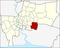 Khet location in Bangkok | |
| Coordinates: 13°43′1″N 100°41′40″E | |
| Country | Thailand |
| Province | Bangkok |
| Seat | Prawet |
| Khwaeng | 3 |
| Khet established | 9 November 1989 |
| Area | |
| • Total | 52.5 km2 (20.3 sq mi) |
| Population (2017) | |
| • Total | 175,656[1] |
| • Density | 3,345.82/km2 (8,665.6/sq mi) |
| Time zone | UTC+7 (ICT) |
| Postal code | 10250 (Dokmai, Mu 2-10 of Nong Bon: 10260) |
| Geocode | 1032 |
History
Prawet was once part of Phra Khanong District. Prawet was elevated to become a separate district in 1989. Part of Prawet, especially the Suan Luang Sub-district, was carved out to establish Suan Luang District on 14 January 1994.
In October 2005 the plan to create the special administrative area Nakhon Suvarnabhumi around the new Bangkok airport became public. Prawet was supposed to be one of five districts to be included in this new area.
Administration
The district is sub-divided into three sub-districts (khwaeng).
| 1. | Prawet | ประเวศ | |
| 2. | Nong Bon | หนองบอน | |
| 3. | Dokmai | ดอกไม้ |
Education
Pan-Asia International School is in Prawet.[2] Wells International School has its Wells International Kindergarten Bangna Campus in Prawet.[3]
References
- "Population and House Report for Year 2017 (see page 2 for data of this district)". Department of Provincial Administration, Ministry of Internal Affairs. Retrieved 1 April 2018. (Search page)
- "About Us". Pan-Asia International School. Retrieved 18 January 2020.
- "Bang Na Campus". Wells International School. Retrieved 18 January 2020.
External links
- Official website of the district (Thai)
- BMA website with the tourist landmarks of Prawet
- Suan Luang Rama IX
.svg.png)