International Cospas-Sarsat Programme
The International Cospas-Sarsat Programme is a satellite-aided search and rescue initiative. It is organized as a treaty-based, nonprofit, intergovernmental, humanitarian cooperative of 45 nations and agencies (see infobox). It is dedicated to detecting and locating radio beacons activated by persons, aircraft or vessels in distress, and forwarding this alert information to authorities that can take action for rescue.[2][3][4]
| Established | 1 July 1988 (definitive agreement signed; preceding memorandums of understanding signed 23 November 1979 and 5 October 1984) |
|---|---|
| Type | Intergovernmental organization |
| Headquarters | Montreal, Quebec, Canada |
Membership | 45 "participant" states
and agencies
|
Official languages | English French Russian |
Head of Secretariat | Steven Lett |
Council Chair (rotating) | Michael Donald (Canada) |
| Website | www |
The system utilizes a network of satellites that provide coverage everywhere on Earth. Distress alerts are detected, located and forwarded to over 200 countries and territories at no cost to beacon owners or the receiving government agencies.[5] Cospas-Sarsat was conceived and initiated by Canada, France, the United States, and the former Soviet Union in 1979.[6] The first rescue using the technology of Cospas-Sarsat occurred in September 1982.[7][8] The definitive agreement of the organization was signed on 1 July 1988.
Background
Cospas-Sarsat is best known as the system that detects and locates emergency beacons activated by aircraft, ships and people engaged in recreational activities in remote areas, and then sends these distress alerts to search-and-rescue (SAR) authorities. Distress beacons capable of being detected by the Cospas-Sarsat System (406-MHz beacons) are available from several manufacturers and vendor chains. Cospas-Sarsat does not make or sell beacons.
Between September 1982 and December 2018 the Cospas-Sarsat System provided assistance in rescuing at least 48,738 people in 14,531 SAR events. In 2016, 2017 and 2018 (the latest year for which statistics have been compiled), Cospas-Sarsat assistance included the following:[9]
| Year | People rescued | SAR events |
|---|---|---|
| 2018 | 2,185 | 904 |
| 2017 | 2,746 | 963 |
| 2016 | 2,057 | 876 |
| SAR events | 2018 | 2017 | 2016 |
|---|---|---|---|
| Aviation | 18% | 17% | 20% |
| Maritime | 38% | 41% | 40% |
| Land | 44% | 42% | 40% |
These statistics under-report the number of events where Cospas-Sarsat assisted, because they only include cases when an accurate report from SAR personnel is provided back through reporting channels to the Cospas-Sarsat Secretariat.
Cospas-Sarsat does not undertake search-and-rescue operations. This is the responsibility of national administrations that have accepted responsibility for SAR in various geographic regions of the world (typically the same geographic area as their flight information region). Cospas-Sarsat provides alert data to those authorities.
Cospas-Sarsat cooperates with United Nations-affiliated agencies, such as the International Civil Aviation Organization (ICAO), the International Maritime Organization (IMO), and the International Telecommunication Union (ITU), among other international organizations, to ensure the compatibility of the Cospas-Sarsat distress alerting services with the needs, the standards and the applicable recommendations of the global community.[10] Cospas-Sarsat is an element of the IMO's Global Maritime Distress Safety System (GMDSS), and is expected to become a component of ICAO's Global Aeronautical Distress and Safety System (GADSS). The IMO requires automatic-activating Cospas-Sarsat beacons (EPIRBs, see below) on all vessels subject to requirements of the International Convention for the Safety of Life at Sea (so-called SOLAS-class vessels), commercial fishing vessels, and all passenger ships in international waters. Similarly, ICAO requires Cospas-Sarsat beacons aboard aircraft on international flights.[11] National administrations often impose requirements in addition to the international requirements of those agencies.
Cospas-Sarsat only monitors for alerts from digital distress beacons that transmit on 406 MHz (so-called 406 beacons). Older beacons that transmit only a legacy analogue signal on 121.5 MHz or 243 MHz rely on being received only by nearby aircraft or rescue personnel. For satellite reception of alerts by Cospas-Sarsat the beacon must be a model that transmits at 406 MHz.[5]
Cospas-Sarsat has received many honors for its humanitarian work. One recent honor was induction into the Space Foundation's Space Technology Hall of Fame for space technologies improving the quality of life for all humanity.[12][13]
System operation
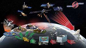
The system consists of a ground segment and a space segment that include:
- Distress radio-beacons to be activated in a life-threatening emergency
- SAR signal repeaters (SARR) and SAR signal processors (SARP) aboard satellites
- Satellite downlink receiving and signal processing ground stations called LUTs (local user terminals)
- Mission control centres (MCCs) that distribute to rescue coordination centres distress alert data (particularly beacon location data) generated by the LUTs
- Rescue coordination centres (RCCs) that facilitate coordination of the SAR agency and personnel response to a distress situation.
Beacons
A Cospas-Sarsat distress beacon is a digital 406-MHz radio transmitter that can be activated in a life-threatening emergency to summon assistance from government authorities. Beacons are manufactured and sold by dozens of vendors. They are classified in three main types. A 406-MHz beacon designed for use in an aircraft is known as an emergency locator transmitter (ELT). One designed for use aboard a marine vessel is called an emergency position-indicating radio beacon (EPIRB). And one that is designed to be carried by an individual is known as a personal locator beacon (PLB). Sometimes PLBs are carried aboard aircraft or vessels, but whether this satisfies safety requirements depends on local regulations.[5] A Cospas-Sarsat 406-MHz beacon does not transmit until it is activated in an emergency (or when certain testing features are activated by the user). Some beacons are designed to be manually activated by a person pressing a button, and some others are designed for automatic activation in certain circumstances (e.g., ELTs may be automatically activated by a physical shock, such as in a crash, and EPIRBs may be automatically activated by contact with water). There are no subscription or other costs imposed by Cospas-Sarsat for beacon ownership or use. (Some countries may impose licensing and/or registration charges for beacon ownership, and some jurisdictions may assess costs for rescue operations.)[14] See below for recent beacon innovations.
Space segment
The Cospas-Sarsat system space segment consists of SARR and/or SARP instruments aboard:[15]
- Five satellites in polar low-altitude Earth orbit called LEOSARs
- Nine satellites in geostationary Earth orbit called GEOSARs
- Approximately 40 satellites in medium-altitude Earth orbit called MEOSARs
A SARR or SARP instrument is a secondary payload and associated antennas attached to those satellites as an adjunct to the primary satellite mission. A SARR instrument retransmits a beacon distress signal to a satellite ground station in real time. A SARP instrument records the data from the distress signal so that the information can later be gathered by a ground station when the satellite passes overhead.
Ground segment
The satellites are monitored by receiving ground stations equipped to track (point at and follow) the satellites using satellite dishes or phased antenna arrays called local user terminals (LUT). LUTs are installed by individual national administrations or agencies. The distress messages received by a LUT are transferred to an associated mission control centre which uses a detailed set of computer algorithms to route the messages to rescue coordination centres worldwide.
System architecture
When a distress beacon is activated, the Cospas-Sarsat system:
- decodes the binary coded message of the beacon, which contains information such as the identity of the vessel/aircraft and, for beacons equipped with the feature, the location of the beacon derived from a local navigation source (such as a GPS receiver incorporated into the beacon's design).
- performs a mathematical analysis of the signal to calculate the location of the beacon, even if the beacon's location is not reported in the distress message.
The Cospas-Sarsat system is the only satellite distress alerting system that is capable of this dual, redundant means of locating an activated distress beacon.
The SARR and/or SARP instrument typically is attached to a satellite that is being launched primarily for another purpose. The primary mission of all of the LEOSAR and GEOSAR satellites is meteorological (gathering of weather data). The primary mission of all of the MEOSAR satellites is navigation.
LEOSAR
LEOSAR was the original Cospas-Sarsat space segment architecture. The complementary LEOSAR-satellite orbits provide periodic coverage of the entire Earth. Because of their relatively low altitude (and therefore, relatively small "footprint" of visibility of any particular part of the Earth at any given time), there are intervals of time when a LEOSAR satellite may not be over a particular geographic location. So there can be a delay in receiving an alert signal, and a delay in relaying that signal to the ground. For this reason, LEOSAR satellites are equipped with the "store-and-forward" SARP modules in addition to "real-time" SARR modules. The satellite can pass over a remote area of the Earth and receive a distress message, and then forward that data later when it passes into view of a ground station (that typically are located in less remote areas). The five satellites in the LEOSAR constellation have approximately 100 minute orbits. Because of their polar orbits the latency between satellite passes overhead is smallest at the poles and higher latitudes.
The Cospas-Sarsat LEOSAR system was made possible by Doppler processing. LUTs detecting distress signals relayed by LEOSAR satellites perform mathematical calculations based on the Doppler-induced frequency shift received by the satellites as they pass over a beacon transmitting at a fixed frequency. From the mathematical calculations, it is possible to determine both bearing and range with respect to the satellite. The range and bearing are measured from the rate of change of the received frequency, which varies both according to the path of the satellite in space and the rotation of the Earth. This allows a computer algorithm to trilaterate the position of the beacon. A faster change in the received frequency indicates that the beacon is closer to the satellite's ground track. When the beacon is moving toward or away from the satellite track due to the Earth's rotation, the Doppler shift induced by that motion also can be used in the calculation.
GEOSAR
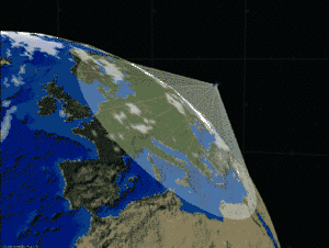
Because their geostationary orbit does not provide a relative motion between a distress beacon and a GEOSAR (Geostationary Search And Rescue) satellite, there is no opportunity to use the Doppler effect to calculate the location of a beacon. Therefore, the GEOSAR satellites only can relay a beacon's distress message. If the beacon is a model with a feature to report its location (e.g., from an on-board GPS receiver) then that location is relayed to SAR authorities. While the inability to independently locate a beacon is a drawback of GEOSAR satellites, those satellites have an advantage in that the present constellation well covers the entire Earth in real time, except for the polar regions.
MEOSAR
The most recent space segment augmentation for Cospas-Sarsat is MEOSAR (Medium Earth Orbiting Search and Rescue). MEOSAR blends the advantages of the LEOSAR and GEOSAR systems, while avoiding the drawbacks. Over time there will be more than 70 MEOSAR satellites, and the MEOSAR system will become the dominant space-segment capability of Cospas-Sarsat. In addition to the large number of satellites, the MEOSAR system benefits from relatively large satellite footprints and sufficient satellite motion relative to a point on the ground to allow the use of Doppler measurements as part of the method of calculating a distress beacon's location. MEOSAR consists of SARR transponders aboard the following navigation-satellite constellations: the European Union's Galileo, the Russian Federation's Glonass, and the United States' Global Positioning System (GPS). With respect to GPS, experimental S-band payloads aboard 19 GPS Block IIR and GPS Block IIF satellites are used operationally by the Cospas-Sarsat System. The first GPS Block IIIA spacecraft with a SAR payload (also S-band) was launched on 23 December 2018, and is under test. The second is scheduled for launch on 25 July 2019. GPS Block IIIF satellites are planned to have dedicated, operational L-band SAR payloads, with launches beginning around 2025. The GPS SAR system is known as Distress Alerting Satellite System (DASS) by NASA.[16][17] China has offered to provide SAR payloads aboard some of its BeiDou (BDS) navigation spacecraft. Two such spacecraft with SAR payloads under test were launched 19 September 2018. Work to integrate the SAR-payload BDS spacecraft into the Cospas-Sarsat System is expected to continue through 2019.
Operational distribution of MEOSAR alert data began at 1300 UTC on 13 December 2016. This operational phase of MEOSAR is known as the early operational capability (EOC), and is being carried out in parallel with continued testing and adjustment through the contemporaneous demonstration and evaluation (D&E) phase. Ultimately, the MEOSAR system will be able to provide near-instantaneous detection, identification, and location-determination of 406-MHz beacons. Prior to the operational introduction of MEOSAR, MEOSAR data was successfully used to assist in determining the crash location of EgyptAir flight 804 in the Mediterranean Sea.[18] The location of a distress beacon is calculated by the receiving LUT by analyzing the frequency-difference-of-arrival (related to Doppler-induced variations), and/or the time-difference-of-arrival of a beacon's radio signal due to the differences in distance between the beacon and each MEOSAR satellite that may be in view.
Additionally, the Galileo component of the MEOSAR system will be able to download information back to the distress radio-beacon by encoding "Return Link Service" messages into the Galileo navigation data stream. Currently it is planned that this capability will be used to activate an indicator on the beacon to confirm receipt of the distress message.[19]
Ground segment
As at April 2019 the LEOSAR (Low-Earth Orbiting Search and Rescue) satellites are tracked and monitored by 65 LEOLUT (low-altitude Earth-orbit local user terminals) antennas, the GEOSAR satellites by 31 GEOLUT antennas and the MEOSAR satellites by 17 experimental and operational MEOLUTs having a total of 76 antennas. The data from these earth stations is transferred to and distributed by 34 MCCs established globally, of which 3 remain under development.[20][21] (See box for the countries and agencies that are ground-segment providers.)
Beacons
There has been one transmission modulation method used by Cospas-Sarsat 406-MHz beacons since their inception more than 30 years ago, binary phase-shift keying (BPSK), with two allowed bit-string lengths: 112 (with 87 bits of message information) and 144 (with 119 bits of message information). Several message protocols are allowed in the available message-bit string to accommodate different kinds of beacons (ELTs, EPIRBs and PLBs), different vessel/aircraft identifiers, and different national requirements. The time length of these transmissions is approximately one-half second. These narrowband transmissions occupy approximately 3 kHz of bandwidth in a channelized scheme across the assigned 406.0 to 406.1 MHz band.[22]
Cospas-Sarsat is in the process of specifying a new, additional beacon modulation and message scheme based on spread-spectrum technology with quadrature phase-shift keying (QPSK). Presently beacons that will use this scheme are termed “second generation” beacons. This technology will allow the use of battery-saving lower-power transmissions, improve the accuracy of the determination of the beacon location by the Cospas-Sarsat System, and avoid the need for discrete channelization in the assigned 406.0 to 406.1 MHz band (e.g., avoiding the need for periodic closing and opening of channels by Cospas-Sarsat for use by beacon manufacturers based on narrowband channel loading). Second-generation beacons will have a longer transmission period of one second, with 250 transmitted bits, 202 of those being message bits. Additionally, the information sent in the message bits from one transmission to the next can be changed on a rotating transmission schedule (“rotating message fields”) to allow significantly more information to be communicated over the course of a series of transmission bursts.[23]
In response to recent commercial aviation disasters and new ICAO requirements for autonomous tracking of aircraft in distress,[24] Cospas-Sarsat is finalizing specifications for ELTs for distress tracking (ELT(DTs)) to meet the ICAO requirements. Whereas present ELTs are designed to activate on impact or by manual activation by the flight crew, ELT(DT)s will activate autonomously when an aircraft enters threatening flight configurations that have been predetermined by expert agencies. In this way, ELT(DT)s will allow a plane in distress to be tracked in-flight, prior to any crash, without human intervention aboard the aircraft. ELT(DT)s are being specified using both the existing beacon transmission method (narrowband BPSK) and the second-generation (spread-spectrum QPSK) modulation schemes.
History

On 23 November 1979 an “Understanding” was signed in Leningrad, USSR, among the U.S. National Aeronautics and Space Administration, the USSR Ministry of Merchant Marine, the French Centre National d’Etudes Spatiales of France, and the Department of Communications of Canada, concerning “cooperation in a joint experimental satellite-aided search and rescue project”. Under Article 3 of the Understanding it was stated that:[25]
“Cooperation will be achieved through effecting interoperability between the SARSAT project and the COSPAS project at 121.5 MHz and in the 406.0 – 406.1 MHz band and conducting of tests, mutual exchange of test results and preparation of a joint report. The objective of this cooperation is to demonstrate that equipment carried on low-altitude, near polar-orbiting satellites can facilitate the detection and location of distress signals by relaying information from aircraft and ships in distress to ground stations, where the information processing is completed and passed to rescue services.”
“This joint Project will permit the Parties to make recommendations on follow-on global applications.”
The first system satellite, "COSPAS-1" (Kosmos 1383), was launched from Plesetsk Cosmodrome on June 29, 1982.[26][27][28] Cospas-Sarsat began tracking the two original types of distress beacons, EPIRBs and ELTs, in September, 1982. The first persons were rescued with the assistance of Cospas-Sarsat when the distress signal from a small plane was relayed by the COSPAS-1 satellite to a then-experimental ground station in Ottawa, Ontario, Canada. The story has been related by the plane's pilot, Jonathan Ziegelheim, who rescue authorities judged would probably have died of his injuries if it were not for Cospas-Sarsat.[29][30][31]
In the early 2000s (in 2003 in the USA) a new type of distress beacon, the personal locator beacon (PLB), became available for use by individuals who cannot contact emergency services through normal telephone-originated services, such as 1-1-2 or 9-1-1. Typically PLBs are used by people engaged in recreational activities in remote areas, and by small-aircraft pilots and mariners as an adjunct to (or, when permitted, a substitute for) an ELT or EPIRB.
The four founding Party States led development of the 406-MHz marine EPIRB for detection by the system. The EPIRB was seen as a key advancement in SAR technology in the perilous maritime environment. Prior to the founding of Cospas-Sarsat, the civilian aviation community had already been using the 121.5 MHz frequency for distress, while the military aviation community utilized 243.0 MHz as the primary distress frequency with the 121.5 MHz frequency as the alternate. ELTs for general aviation aircraft were constructed to transmit on 121.5 MHz, a frequency monitored by airliners and other aircraft. Military aircraft beacons were manufactured to transmit at 243.0 MHz, in the band commonly used by military aviation. Early in its history, the Cospas-Sarsat system was engineered to detect beacon-alerts transmitted at 406 MHz, 121.5 MHz and 243.0 MHz. Because of a large number of false alerts, and the inability to uniquely identify such beacons because of their old, analogue technology, the Cospas-Sarsat system beginning in 2009 stopped receiving alerts from beacons operating at 121.5 MHz and 243.0 MHz, and now only receives and processes alerts from modern, digital 406-MHz beacons. Many ELTs include both a 406-MHz transmitter for satellite detection and a 121.5 MHz transmitter that can be received by local search crews using direction-finding equipment.
The design of distress beacons as a whole has evolved significantly since 1982. The newest 406-MHz beacons incorporate GPS receivers. Such beacons transmit in their distress message highly accurate position reports. The distress alert and location are forwarded almost instantly to SAR agencies via Cospas-Sarsat satellites. This provides a second method for Cospas-Sarsat to know the location of the distress, in addition to the calculations independently done by Cospas-Sarsat LUTs to determine the location. This two-tiered reliability and global coverage of the system has inspired the current motto of SAR agencies: "Taking the 'Search' out of Search and Rescue.".
COSPAS (КОСПАС) is an acronym for the Russian words "Cosmicheskaya Sistema Poiska Avariynyh Sudov" (Космическая Система Поиска Аварийных Судов), which translates to "Space System for the Search of Vessels in Distress". SARSAT is an acronym for Search And Rescue Satellite-Aided Tracking.[32]
References
- Galileo’s Contribution to Cospas-Sarsat
- International Cospas-Sarsat Programme Agreement – UN Treaty Series (PDF)
- Cospas-Sarsat website, "International Cospas-Sarsat Programme Agreement" (PDF)
- Cospas-Sarsat website, "Cospas-Sarsat Strategic Plan", at section 3, "The International Cospas-Sarsat Programme provides accurate, timely and reliable distress alert and location data to help search and rescue authorities assist persons in distress." (PDF)
- Cospas-Sarsat website, "What is a Cospas-Sarsat 406 MHz Beacon"
- Space Foundation's Space Technology Hall of Fame inducted technology
- The Washington Post, 30 September 1982, page A3
- The Hartford Courant, 25 November 1982, page A6
- Cospas-Sarsat website, "Cospas-Sarsat Report on System Status and Operations No.35, January-December 2018" (PDF)
- Cospas-Sarsat website, "Cospas-Sarsat Strategic Plan", at section 2.1 (PDF)
- AIN Online, "New ELT Rules from ICAO
- Space Foundation Website
- Space Technology Hall of Fame induction ceremony
- Cospas-Sarsat Website, "Handbook of (National) Beacon Regulations"
- Cospas-Sarsat Website, "Current Space Segment Status and SAR Payloads"
- GPS World (January 2011) : The Distress Alerting Satellite System (DASS)
- New York Times article, "Black Box from Missing EgyptAir Flight 804 is Said to be Detected"
- European Commission Website, "SAR Galileo Initial Service"
- Cospas-Sarsat Website, "Cospas-Sarsat System"
- Cospas-Sarsat Website, "Cospas-Sarsat System Data" (PDF)
- Cospas-Sarsat website, "Specification for Cospas-Sarsat 406 MHz Distress Beacons", at section 2 (PDF)
- Cospas-Sarsat website, "Specification for Second-Generation Cospas-Sarsat 406-MHz Distress Beacons", at section 2 (PDF)
- ICAO Update on the Global Aeronautical Distress and safety System (GADSS) Global Aircraft Tracking Initiatives (March 2016) (PDF)
- Cospas-Sarsat website, "The History and Experience of the International Cospas-Sarsat Programme for Satellite-Aided Search and Rescue", at page 20 (PDF)
- Hillger, Don; Garry Toth. "COSPAS / SARSAT Program". Colorado State University. Retrieved 6 October 2011.
- Krebs, Gunter Dirk. "Nadezhda". Retrieved 6 October 2011.
- Kramer, Herbert J. "COSPAS-S&RSAT (International Satellite System for Search & Rescue Services)". eoportal. Retrieved 6 October 2011.
- Cospas-Sarsat Website, Information Bulletin, page 2 (PDF)
- The Washington Post, 30 September 1982, page A3
- The Hartford Courant, 25 November 1982, page A6
- "Cospas-Sarsat Glossary, document C/S G.004" (PDF).
External links
- Official Website for the International Cospas-Sarsat Programme
- International Astronautical Federation, "The History and Experience of the International Cospas-Sarsat Programme for Satellite-Aided Search and Rescue"
- Official Website for the USA's Sarsat Program
- Official Website for NASA’s Search-and-Rescue Mission Office
- "Detailed SARSAT and COSPAS satellite information". Archived from the original on August 15, 2015. Retrieved September 8, 2015.
- "Lay Person Explanation of the Satellite System: COSPAS-SARSAT: 14,000 Lives Saved and Counting". Archived from the original on January 13, 2015. Retrieved September 23, 2006.CS1 maint: BOT: original-url status unknown (link)