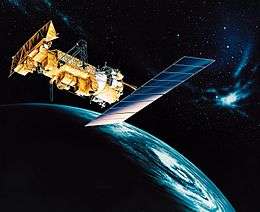
NOAA-12
NOAA-12, also known as NOAA-D, was a U.S. weather satellite operated by the NOAA for use in the National Environmental Satellite Data and Information Service (NESDIS). It was part of a series of satellites called Advanced TIROS-N, being the fifth of the series.[6] NOAA-12 was launched on an Atlas E rocket on May 14, 1991 from Vandenberg Air Force Base, California.
| Mission type | Weather |
|---|---|
| Operator | NOAA |
| COSPAR ID | 1991-032A |
| SATCAT no. | 21263 |
| Spacecraft properties | |
| Manufacturer | GE Astrospace[1] |
| Launch mass | 3,126 pounds (1,418 kg)[2] |
| Dry mass | 1,620 pounds (730 kg)[2] |
| Dimensions | Spacecraft: 3.71 m × 1.88 m (12.2 ft × 6.2 ft) Solar array: 2.37 m × 4.91 m (7.8 ft × 16.1 ft) |
| Power | 880 watts |
| Start of mission | |
| Launch date | May 14, 1991, 15:52:03 UTC[3] |
| Rocket | Atlas-E Star-37S-ISS |
| Launch site | Vandenberg SLC-3W |
| End of mission | |
| Disposal | Decommissioned |
| Last contact | August 10, 2007[4] |
| Orbital parameters | |
| Reference system | Geocentric |
| Regime | Low Earth Sun-synchronous |
| Semi-major axis | 7,183.0 kilometers (4,463.3 mi) |
| Eccentricity | 0.0012739 |
| Perigee altitude | 803.6 kilometers (499.3 mi) |
| Apogee altitude | 821.9 kilometers (510.7 mi) |
| Inclination | 98.5353 degrees |
| Period | 101 minutes |
| RAAN | 209.5967 degrees |
| Argument of perigee | 228.0771 degrees |
| Mean anomaly | 131.9324 degrees |
| Mean motion | 14.258717784 |
| Epoch | July 9, 2018[5] |
| Revolution no. | 41158 |
Advanced TIROS-N | |
The satellite design provides an economical and stable sun-synchronous (morning equator-crossing) platform for advanced operational instruments to measure the earth's atmosphere, its surface and cloud cover, and the near-space environment.[6] The Satellite Operations Control Center is located in Suitland, Maryland. Major command stations for satellite control are located near Fairbanks, Alaska and on Wallops Island, Virginia; a backup station for connection when the satellite is unavailable from the main stations is located at Point Barrow, Alaska.
The last contact occurred on August 10, 2007.[2]
Instruments
- ARGOS Data Collection System
- Advanced Very High Resolution Radiometer: Cassegrain telescope with a 203 mm aperture diameter for imaging the Earth and cloud surface in the visible and infrared portion of the spectrum (5 channels, wavelength 0.5 μm to 12.5 μm, spatial resolution 0.62 miles (1.00 km) to 2.5 miles (4.0 km));
- High-resolution Infra Red Sounder
- Microwave Sounding Unit
- Stratospheric Sounding Unit
- SEM/Medium energy proton Detector: Instrument for detection of corpuscular radiation from solar eruptions (electrons 30 keV-300 keV, protons 30-2500 keV, α particles above 6 MeV);
- SEM/Total Energy Detector: Instrument for determination of the total energy of bringing into the atmosphere electrons, protons and positive ions (range of electrons and protons 0.05 keV to 20 keV).[2]
References
- Vítek, Antonin (September 24, 1991). "1991-032A - NOAA-12". Space 40 (in Czech). Retrieved July 6, 2018.
- "Satellite: NOAA-12". World Meteorological Organization. December 11, 2017. Retrieved July 6, 2018.
- McDowell, Jonathan. "Launch Log". Jonathan's Space Page. Retrieved July 6, 2018.
- NOAA, U.S. Department of Commerce (January 29, 2015). "POES Decommissioned Satellites". Retrieved July 6, 2018.
- n2yo.com. "NOAA 12". Retrieved July 9, 2018.
- NASA, Goddard Space Flight Center. "NOAA-12". NSSDCA. Retrieved July 4, 2018.

External links
![]()
- NOAA 8, 9, 10, 11, 12, 13, 14 (NOAA E, F, G, H, D, I, J). Gunter's Space Page
- NOAA 12. TSE
- Orbital Tracking
