Plaistow, Bromley
Plaistow (/ˈplɑːstoʊ/ PLAHST-oh, /ˈplæstoʊ/ PLAST-oh, or /ˈpleɪstoʊ/ PLAYST-oh[2][3][4]) is a village in the London Borough of Bromley, bordered by the London Borough of Lewisham to the north. It is within the Bromley post town and the BR postcode area. The main road in Plaistow is Burnt Ash Lane, part of the A2212 road which runs north to south between Grove Park and Bromley.
| Plaistow, Bromley | |
|---|---|
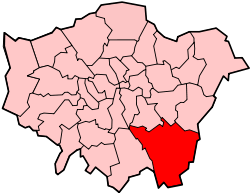
 Plaistow, Bromley Location within Greater London | |
| Population | 15,122 (2011 Census. Plaistow and Sundridge Ward)[1] |
| London borough | |
| Ceremonial county | Greater London |
| Region | |
| Country | England |
| Sovereign state | United Kingdom |
| Postcode district | BR1 |
| Police | Metropolitan |
| Fire | London |
| Ambulance | London |
| London Assembly | |
Plaistow was still countryside in the 1860s, when Bromley was still part of the county of Kent. Housing development began after the arrival of the railway. St Mary’s Church was consecrated in 1863 and enlarged three times between 1881 and 1900. The churchyard closed for burials in 1893 when Plaistow Cemetery opened.[5]
References
- "Bromley Ward population 2011". Neighbourhood Statistics. Office for National Statistics. Retrieved 11 October 2016.
- Wells, J. C. (2008). Longman Pronunciation Dictionary, 3rd edn, Harlow, UK: Longman
- Daniel Jones, Peter Roach, et al. (2011). Cambridge Pronouncing Dictionary, 18th edn, Cambridge, UK: Cambridge University Press
- Martha Figueroa-Clark,"BBC - Magazine Monitor: How to Say: Plaistow", BBC, 16 October 2009. Retrieved 2015-11-21.
- "London Gardens Online, St Mary's Churchyard, Plaistow". London Parks and Gardens Trust. Retrieved 18 February 2013.
This article is issued from Wikipedia. The text is licensed under Creative Commons - Attribution - Sharealike. Additional terms may apply for the media files.