Crofton, London
Crofton is a suburb of Orpington in southeast London, England and is within the London Borough of Bromley. It is about 13.6 miles (21.9 km) southeast of Charing Cross.
| Crofton | |
|---|---|
 208 bus route at Crofton junction | |
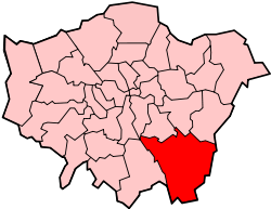
 Crofton Location within Greater London | |
| Population | 14,632 (2011 Census) |
| OS grid reference | TQ445658 |
| • Charing Cross | 13.6 mi (21.9 km) NW |
| London borough | |
| Ceremonial county | Greater London |
| Region | |
| Country | England |
| Sovereign state | United Kingdom |
| Post town | ORPINGTON |
| Postcode district | BR5, BR6 |
| Police | Metropolitan |
| Fire | London |
| Ambulance | London |
| UK Parliament | |
| London Assembly | |
Governance
Crofton falls within the London Borough of Bromley and is in the Orpington Parliament constituency.[1] For local council elections it forms a part of the Farnborough and Crofton ward along with Farnborough.[2]
Demography
Demographic data is produced by the Office for National Statistics for the Farnborough and Crofton ward. In the 2011 census, the population for the Farnborough and Crofton ward was 14,632.[3] The most common ethnic group was White British in the Farnborough and Crofton ward, measured as 90.5%, followed by Asian or British Asian (5.5%) and mixed-race (1.9%). The remaining percentage was made up of Black or Black British and other unspecified ethnic groups.[4]
Transport

Crofton has no railway station of its own, but east of Crofton is Orpington railway station which runs on the South Eastern main line.
There is good bus infrastructure in Crofton, having six daytime routes, one nighttime routes and one school bus route. Buses in Crofton include bus routes 61, 208, 353, N199, R2, R3, R7 and school route 654 with connections to many towns, villages and suburbs such as Biggin Hill, Bromley town centre, Catford, Lewisham town centre, Petts Wood, St Mary Cray and several other areas.[5]
See also
References
- "The Parliamentary Constituencies (England) Order 2007". www.legislation.gov.uk. Retrieved 6 May 2019.
- "Map of ward boundaries | London Borough of Bromley". www.bromley.gov.uk. Retrieved 6 May 2019.
- "Archived copy". Archived from the original on 22 February 2019. Retrieved 4 May 2019.CS1 maint: archived copy as title (link)
- "Ethnic group". NOMIS. Office for National Statistics. Retrieved 4 May 2019.
- "Buses from Crofton (Orpington)" (PDF). Transport for London. Retrieved 7 May 2019.