Jingtai County
Jingtai County (Chinese: 景泰县; pinyin: Jǐngtài Xiàn) is a county in the middle of Gansu Province, bordering Inner Mongolia to the north. It is under the administration of Baiyin City and located at its northwest end. Covering an administrative area of 5,483 square kilometers, it governs 8 towns, 3 townships, 136 administrative villages and 7 communities.[1] Its postal code is 730400, and its population in 1999 was 230,415 people. It has an obvious advantage of location in the junction of Gansu, Ningxia and Inner Mongolia. Historically, it was a military hub, a vital communication center of the Silk Road, an important ferry, and also a major transformation route to Hexi, Xinjiang, Ningxia and Inner Mongolia. Starting from 1933, the name of Jingtai County means "prosperity of the scene, peace of the country and the people".[1]
Jingtai County 景泰县 | |
|---|---|
County | |
 Xingquanbao, more than 100 wind turbines wind farm on Jingtai County | |
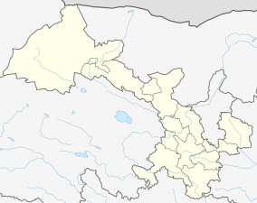 Jingtai Location of the seat in Gansu | |
| Coordinates: 37°11′02″N 104°03′50″E | |
| Country | People's Republic of China |
| Province | Gansu |
| Prefecture-level city | Baiyin |
| Area | |
| • Total | 5,483 km2 (2,117 sq mi) |
| Highest elevation | 3,321 m (10,896 ft) |
| Lowest elevation | 1,276 m (4,186 ft) |
| Population (2018) | 240,000 |
| Time zone | UTC+8 (China Standard) |
| Website | www |
Administrative divisions
Jingtai is divided into 8 towns and 3 townships:[2]
- Yitiaoshan (一条山镇)
- Luyang (芦阳镇)
- Shanshawo (上沙沃镇)
- Xiquan (喜泉镇)
- Caowotan (草窝滩镇)
- Hongshui (红水镇)
- Zhongquan (中泉镇)
- Zhenlu (正路镇)
- Sitan Township (寺滩乡)
- Wufo Township (五佛乡)
- Manshuitan Township (漫水滩乡)
Economy
Jingtai has 385 million tons in gypsum reserves, the second highest amount in China, and over 800 million tons of limestone, 380 million tons of coal, over 20 million tons of quartz, over 2 million tons of copper and in addition some reserves of gold, silver, manganese, Moyu jade, clay and serpentinite. Local industries include production of cement, ferrosilicon, malt, livestock feed, gypsum powder and coal.[3]
Agriculture

Geographical location and special irrigation system provide Jingtai County with unique conditions for agricultural development. The Yellow River flows through Jingtai County for 112 kilometers. There is the Jingtai chuan electric power lifting and irrigation project known as "the most in Asia".[4] There are two large-scale, nationwide noted, irrigation projects with a total capacity of 245,600 kW and a water lifting capacity of 28.6 m³ per second. The whole county has arable land of over 680 square kilometers and irrigated lands of nearly 400 square kilometers. Located at 37 degrees north latitude, it has advantages of long hours of light and a large temperature difference between day and night for high-quality agricultural products.[4] Crops grown in Jingtai are wheat, corn, pears, melons and apricot.[3] The special agricultural products mainly include desert wolfberry, pear, red date, Dajie apricot, apple, small grains, desert melon, Gobi fish, shrimp, crab, licorice sheep. Among these products, "Jingtai wolfberry", "Tiaoshan pear", "Longwan apple", and "Cuiliu mutton" have obtained the certification for national agricultural product geographical indication. A total of 62 products meets the "sanpinyibiao" (three types of products and the agricultural product geographical indication) and 47 products are considered as green, pollution-free, non-toxic, safe and high-quality food.[4]
Tourism
Jingtai county is home to a some touristic sites:
Yellow River Stone Forest
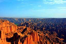
Yellow River Stone Forest is located in the southeast of Jingtai County, Baiyin City, Gansu Province. It is 70 kilometers away from Jingtai County. The park has an total area of 50 square kilometers, and the ancient stone forest group covers 10 square kilometers, which is formed in the lower Pleistocene Wuquanshan proluvial gravel layer 2.1 million years ago. The action of neotectonic movements, rain and flood erosions and gravitational collapse forms this peak cluster landscape with vertical and sharply contoured rock strata.[5]
Yongtai Fortress
Yongtai Fortress is located in the north foot of Tiger mountain, Sitan Township, Jingtai County. It is also called Yongtai tortoise city because of its tortoise-like castle. It is the most representative and well preserved military castle of Ming Dynasty along the Silk Road. Historically, it is an important part of the Ming Great Wall, which is built as a border defense system. Now, it is a national cultural relic, a historical village representing the culture of Gansu Province and a place for art creation.[5]
Shoulushan National Forest Park
Shoulushan National Forest Park is located at the junction of Gansu, Ningxia and Inner Mongolia. It is 39 kilometers aways from Jingtai County and covers an area of 10.86 square kilometers. With an average altitude of 2,800 meters, the monthly temperature during May to October is between 2.2-15.2 degrees Celsius.[5]
The Great Dunhuang Film-making Base
The Great Dunhuang Film-making Base, next to the 201 provincial road, is located in dashuigu village, Xiquan Town, Jingtai County, Gansu Province. Following the history style, there are many ancient buildings, caves, archways, city gate towers, a street imitating Ming Dynasty and Qing Dynasty, artificial lakes and other natural scenes. Within the film-making studio, murals, sculptures and giant Buddhas are created in the style of Mogao Grottoes in Dunhuang.[5]
- Over 20 kilometers away from the Jingtai County, the Great Dunhuang Film-making Base is on the road that connects Yellow River Stone Forest, Yongtai Fortress and Shoulushan National Forest Park. Convenient transportation and location advantages of natural scenes provide this place with unique conditions for creating films and art work represent Western China.[6]
- In 2004, Chen Jialin, a famous Chinese director, happened to find this red stone mountain on the way to Jingtai County. The strange trend of this mountain with uneven pits and densely distributed caves is similar to Mogao Grottoes in Dunhuang. He decided to copy the Mogao Grottoes here as the location for his TV series "The Great Dunhuang".[6]
- In 2005, Jingtai County invested 6 million yuan to build this film-making base.[6]
- In 2006, the Great Dunhuang Film-making Base was listed as a provincial film-making base. More than 60 movies and TV series have been filmed here by 2019.[6]
Culture
Film and TV series
- Welcome to Shama Town (set in Yongtai Fortress)[7]
- The Myth (set in Yellow River Stone Forest)[7]
- Oh My General (set in Yellow River Stone Forest)[7]
- The Great Dunhuang (set in the Great Dunhuang Film-making Base)[7]
Activities
Jingtai County has successfully held the Yellow River Stone Forest international hiking race with over 10 thousands people, the Yellow River Stone Forest culture and tourism festival, Wufo red date festival and other major events representing unique scenes and agricultural products of Jingtai.[8]
Transport
References
- "景泰概况_景泰县人民政府网". www.jingtai.gov.cn. Retrieved 2020-04-27.
- "历史沿革_景泰县人民政府网". www.jingtai.gov.cn.
- "自然地理_景泰县人民政府网". www.jingtai.gov.cn.
- "甘肃景泰在天津推介旅游资源和农特产品-甘肃旅游网". www.tourgansu.com. Retrieved 2020-04-27.
- "风景名胜_景泰县人民政府网". www.jingtai.gov.cn. Retrieved 2020-04-27.
- "景泰有个"大敦煌"-甘肃旅游网". www.tourgansu.com. Retrieved 2020-04-27.
- "【精品纪录片】光影景泰|影视作品中的景泰,你熟悉吗?". baijiahao.baidu.com. Retrieved 2020-04-27.
- "景泰——西部风情之旅". www.sohu.com. Retrieved 2020-04-27.
| ||
| ||
| Authority control |
|
|---|