Phu Sang District
Phu Sang District (Thai: ภูซาง, pronounced [pʰūː sāːŋ]) is a district (amphoe) of Phayao Province in northern Thailand.
Phu Sang ภูซาง | |
|---|---|
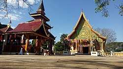 Wat Thung Kluai a local temple in district | |
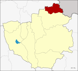 District location in Phayao Province | |
| Coordinates: 19°35′57″N 100°19′27″E | |
| Country | Thailand |
| Province | Phayao |
| Seat | Pa Sak |
| Area | |
| • Total | 293.486 km2 (113.316 sq mi) |
| Population (2007) | |
| • Total | 31,407 |
| • Density | 107.0/km2 (277/sq mi) |
| Time zone | UTC+7 (ICT) |
| Postal code | 56110 |
| Geocode | 5608 |
Geography
Neighboring districts are (from the south clockwise): Chiang Kham of Phayao Province and Thoeng of Chiang Rai Province. To the northeast is Xaignabouli Province of Laos.
History
The minor district was established on 26 June 1996. The new district became effective on 15 July and covered five tambons previously belonging to Chiang Kham District.[1]
On 15 May 2007, all 81 minor districts were upgraded to full districts.[2] With publication in the Royal Gazette on 24 August the upgrade became official.[3]
Administration
The district is divided into five sub-districts (tambons), which are further subdivided into 58 villages (mubans). Sop Bong is a sub-district municipality (thesaban tambon) which covers tambon Sop Bong. There are a further four tambon administrative organizations (TAO).
| No. | Name | Thai | Villages | Pop. |
|---|---|---|---|---|
| 1. | Phu Sang | ภูซาง | 9 | 6,425 |
| 2. | Pa Sak | ป่าสัก | 10 | 4,218 |
| 3. | Thung Kluai | ทุ่งกล้วย | 12 | 7,738 |
| 4. | Chiang Raeng | เชียงแรง | 6,007 | |
| 5. | Sop Bong | สบบง | 12 | 7,019 |
References
- ประกาศกระทรวงมหาดไทย เรื่อง แบ่งเขตท้องที่อำเภอเชียงคำ จังหวัดพะเยา ตั้งเป็นกิ่งอำเภอภูซาง (PDF). Royal Gazette (in Thai). 113 (Special 18 ง): 28. June 26, 1996.
- แถลงผลการประชุม ครม. ประจำวันที่ 15 พ.ค. 2550 (in Thai). Manager Online.
- พระราชกฤษฎีกาตั้งอำเภอฆ้องชัย...และอำเภอเหล่าเสือโก้ก พ.ศ. ๒๕๕๐ (PDF). Royal Gazette (in Thai). 124 (46 ก): 14–21. August 24, 2007.