Philipsburg, Sint Maarten
Philipsburg is the main town and capital of the country of Sint Maarten. The town is situated on a narrow stretch of land between Great Bay and the Great Salt Pond. It functions as the commercial center of Saint Martin island, whereof Sint Maarten encompasses the southern half. As of 2017, it has 1,894 inhabitants.[1]
Philipsburg | |
|---|---|
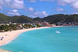 View on Great Bay towards Philipsburg | |
| Nickname(s): Town | |
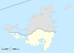 Philipsburg Location in Sint Maarten | |
| Coordinates: 18.0237°N 63.0458°W | |
| State | |
| Country | |
| Island | Saint Martin |
| Columbus landed | 11 November 1493 |
| Established | 1763 (by John Philips) |
| Population (2017) | |
| • Total | 1,894 |
| Climate | Aw |
History
Philipsburg was founded in 1763 by John Philips, a Scottish captain in the Dutch navy; the settlement soon became a bustling centre of international trade. Two historic forts bear witness to Philipsburg's strategic importance in St. Maarten's history: Fort Amsterdam and Fort Willem.[2]
- See also
- List of Designated Monuments in Philipsburg
Climate
Philipsburg has a tropical savanna climate (Köppen Aw),[3] and is drier than most parts of the northeastern Caribbean due to a rain shadow from the island's mountains, drying the northeast trade winds. The driest months are from January to July, and the wettest from September to November, when hurricanes are a frequent occurrence in the region.
| Climate data for Philipsburg, Sint Maarten (Princess Juliana Airport) 1971–2000 | |||||||||||||
|---|---|---|---|---|---|---|---|---|---|---|---|---|---|
| Month | Jan | Feb | Mar | Apr | May | Jun | Jul | Aug | Sep | Oct | Nov | Dec | Year |
| Record high °C (°F) | 32.7 (90.9) |
31.6 (88.9) |
32.6 (90.7) |
33.6 (92.5) |
33.5 (92.3) |
33.9 (93.0) |
34.2 (93.6) |
35.1 (95.2) |
34.8 (94.6) |
34.3 (93.7) |
33.9 (93.0) |
32.1 (89.8) |
35.1 (95.2) |
| Average high °C (°F) | 28.6 (83.5) |
28.7 (83.7) |
29.2 (84.6) |
29.8 (85.6) |
30.4 (86.7) |
31.3 (88.3) |
31.6 (88.9) |
31.7 (89.1) |
31.6 (88.9) |
31.2 (88.2) |
30.2 (86.4) |
29.2 (84.6) |
30.3 (86.5) |
| Daily mean °C (°F) | 25.5 (77.9) |
25.4 (77.7) |
25.7 (78.3) |
26.5 (79.7) |
27.4 (81.3) |
28.2 (82.8) |
28.3 (82.9) |
28.6 (83.5) |
28.5 (83.3) |
28.2 (82.8) |
27.3 (81.1) |
26.1 (79.0) |
27.2 (81.0) |
| Average low °C (°F) | 23.2 (73.8) |
23.1 (73.6) |
23.5 (74.3) |
24.1 (75.4) |
25.1 (77.2) |
25.2 (77.4) |
26.1 (79.0) |
26.2 (79.2) |
26.0 (78.8) |
25.7 (78.3) |
24.9 (76.8) |
23.9 (75.0) |
24.8 (76.6) |
| Record low °C (°F) | 18.6 (65.5) |
19.2 (66.6) |
19.5 (67.1) |
19.3 (66.7) |
20.2 (68.4) |
22.3 (72.1) |
22.1 (71.8) |
21.4 (70.5) |
22.0 (71.6) |
22.1 (71.8) |
21.2 (70.2) |
20.0 (68.0) |
18.6 (65.5) |
| Average rainfall mm (inches) | 66.0 (2.60) |
50.7 (2.00) |
45.2 (1.78) |
64.0 (2.52) |
93.3 (3.67) |
61.8 (2.43) |
71.6 (2.82) |
98.8 (3.89) |
139.6 (5.50) |
113.0 (4.45) |
149.3 (5.88) |
93.8 (3.69) |
1,047.1 (41.22) |
| Average rainy days (≥ 1.0 mm) | 11.9 | 9.3 | 9.0 | 11.8 | 10.3 | 8.4 | 12.2 | 13.9 | 13.5 | 13.8 | 14.8 | 13.3 | 142.0 |
| Average relative humidity (%) | 74.7 | 74.1 | 73.6 | 75.0 | 75.9 | 75.1 | 74.8 | 75.4 | 76.3 | 76.8 | 77.4 | 76.6 | 75.5 |
| Mean monthly sunshine hours | 257.2 | 235.2 | 271.6 | 265.4 | 251.0 | 245.1 | 257.2 | 288.1 | 232.4 | 244.6 | 235.0 | 246.7 | 3,009.4 |
| Percent possible sunshine | 73.5 | 72.7 | 72.2 | 70.6 | 62.4 | 62.0 | 63.2 | 67.7 | 62.8 | 67.0 | 68.3 | 71.4 | 67.8 |
| Source: Meteorological Department Curaçao[4] | |||||||||||||
Tourism
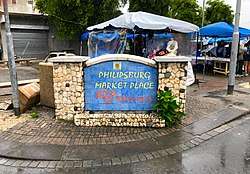
The main shopping district, Front Street, is in the heart of the city. The city also has a port that is visited by many cruise liners.
Transport
Princess Juliana International Airport
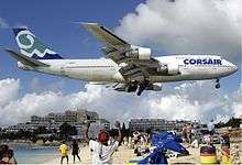
World-famous for its close photographs of landing aircraft, Princess Juliana International Airport (IATA: SXM, ICAO: TNCM), west of Philipsburg, has become a tourist destination in its own right. Jet blast from departing aircraft is another 'attraction' as it creates artificial waves. However, jet blast is physically hazardous so viewers need to exercise caution; local authorities placed a warning on the airport's fence to alert people to the dangers of jet blast.
Education
Schools include:[5]
- Oranje School (public primary)
- Sr. Borgia Primary (subsidized primary)
- St. Joseph Primary (subsidized primary)
- Sundial School (subsidized secondary)
Philipsburg Jubilee Library is in Philipsburg.[6]
References
- "Statistical Yearbook 2017" (PDF). Department of Statistics Sint Maarten. 2017. Retrieved 2020-01-08.
- "Accenting St. Maarten, Dutch Caribbean". geographia.com.
- "Philipsburg, Sint Maarten Köppen Climate Classification (Weatherbase)". Weatherbase.
- "Summary of Climatological Data, Period 1971-2000" (PDF). Meteorological Department Curaçao. Archived from the original (PDF) on July 2, 2013. Retrieved September 22, 2016.
- "School Directory ." Sint Maarten Government. Retrieved on February 28, 2018.
- "Contact Us." Philipsburg Jubilee Library. Retrieved on February 28, 2018. "Our Address: Ch. E.W. Vogestreet 12 Philipsburg, St. Maarten."
External links
| Wikimedia Commons has media related to Philipsburg, Sint Maarten. |
| Authority control |
|
|---|