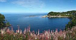
Petite-Vallée, Quebec
Petite-Vallée is a municipality in the Gaspésie-Îles-de-la-Madeleine region of the province of Quebec in Canada.
Petite-Vallée | |
|---|---|
Municipality | |
 | |
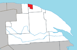 Location within La Côte-de-Gaspé RCM. | |
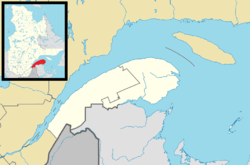 Petite-Vallée Location in eastern Quebec. | |
| Coordinates: 49°13′N 65°02′W[1] | |
| Country | |
| Province | |
| Region | Gaspésie–Îles-de-la-Madeleine |
| RCM | La Côte-de-Gaspé |
| Constituted | January 1, 1957 |
| Government | |
| • Mayor | Noel-Marie Clavet |
| • Federal riding | Gaspésie—Îles-de-la-Madeleine |
| • Prov. riding | Gaspé |
| Area | |
| • Total | 40.80 km2 (15.75 sq mi) |
| • Land | 39.28 km2 (15.17 sq mi) |
| Population (2011)[3] | |
| • Total | 178 |
| • Density | 4.5/km2 (12/sq mi) |
| • Pop 2006-2011 | |
| • Dwellings | 97 |
| Time zone | UTC−5 (EST) |
| • Summer (DST) | UTC−4 (EDT) |
| Postal code(s) | G0E 1Y0 |
| Area code(s) | 418 and 581 |
| Highways | |
The municipality was formed in 1957, when it separated from the Township Municipality of Cloridorme. Its name (French for "Little Valley") describes its location in the hollow of a shallow valley and dates back to at least 1754 when it appeared on a map by Jacques-Nicolas Bellin.[1]
Demographics
Population
| Canada census – Petite-Vallée, Quebec community profile | |||
|---|---|---|---|
| 2011 | 2006 | ||
| Population: | 178 (-28.2% from 2006) | 248 (+14.8% from 2001) | |
| Land area: | 39.28 km2 (15.17 sq mi) | 39.28 km2 (15.17 sq mi) | |
| Population density: | 4.5/km2 (12/sq mi) | 6.3/km2 (16/sq mi) | |
| Median age: | 56.0 (M: 57.0, F: 55.0) | 50.0 (M: 48.5, F: 51.0) | |
| Total private dwellings: | 97 | 112 | |
| Median household income: | $.N/A | $.N/A | |
| Notes: Income data for this area has been suppressed for data quality or confidentiality reasons. – References: 2011[3] 2006[4] earlier[5] | |||
| Historical Census Data - Petite-Vallée, Quebec[6] | ||||||||||||||||||||||||||
|---|---|---|---|---|---|---|---|---|---|---|---|---|---|---|---|---|---|---|---|---|---|---|---|---|---|---|
|
|
| ||||||||||||||||||||||||
Language
| Canada Census Mother Tongue - Petite-Vallée, Quebec[6] | ||||||||||||||||||
|---|---|---|---|---|---|---|---|---|---|---|---|---|---|---|---|---|---|---|
| Census | Total | French |
English |
French & English |
Other | |||||||||||||
| Year | Responses | Count | Trend | Pop % | Count | Trend | Pop % | Count | Trend | Pop % | Count | Trend | Pop % | |||||
2011 |
175 |
175 | 100.00% | 0 | 0.00% | 0 | 0.00% | 0 | 0.00% | |||||||||
2006 |
260 |
260 | 100.00% | 0 | 0.00% | 0 | 0.00% | 0 | 0.00% | |||||||||
2001 |
225 |
225 | 100.00% | 0 | 0.00% | 0 | 0.00% | 0 | 0.00% | |||||||||
1996 |
195 |
195 | n/a | 100.00% | 0 | n/a | 0.00% | 0 | n/a | 0.00% | 0 | n/a | 0.00% | |||||
See also
| Wikivoyage has a travel guide for Grande-Vallée and Petite-Vallée. |
References
- "Petite-Vallée (Municipalité)" (in French). Commission de toponymie du Québec. Retrieved 2011-12-06.
- "Petite-Vallée". Répertoire des municipalités (in French). Ministère des Affaires municipales, des Régions et de l'Occupation du territoire. Archived from the original on 2012-06-07. Retrieved 2011-12-06.
- "2011 Community Profiles". 2011 Canadian Census. Statistics Canada. July 5, 2013. Retrieved 2013-05-13.
- "2006 Community Profiles". 2006 Canadian Census. Statistics Canada. March 30, 2011. Retrieved 2011-12-06.
- "2001 Community Profiles". 2001 Canadian Census. Statistics Canada. February 17, 2012.
- Statistics Canada: 1996, 2001, 2006, 2011 census
Adjacent Municipal Subdivisions | ||||||||||
|---|---|---|---|---|---|---|---|---|---|---|
| ||||||||||
| Cities | |
|---|---|
| Municipalities | |
| Townships | |
| Unorganized Territories | |
| |
This article is issued from Wikipedia. The text is licensed under Creative Commons - Attribution - Sharealike. Additional terms may apply for the media files.