Murdochville, Quebec
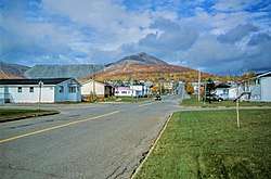
Murdochville is a town in Quebec, Canada, one of only a few inland communities on the Gaspé Peninsula. Its population (as of 2011) is 764.
Murdochville | |
|---|---|
City | |
 | |
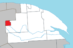 Location within La Côte-de-Gaspé RCM. | |
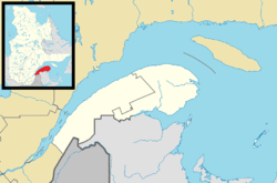 Murdochville Location in eastern Quebec. | |
| Coordinates: 48°58′N 65°30′W[1] | |
| Country | |
| Province | |
| Region | Gaspésie–Îles-de-la-Madeleine |
| RCM | La Côte-de-Gaspé |
| Settled | 1950 |
| Constituted | July 15, 1953 |
| Government | |
| • Mayor | Délisca Ritchie Roussy |
| • Federal riding | Gaspésie—Îles-de-la-Madeleine |
| • Prov. riding | Gaspé |
| Area | |
| • Total | 63.80 km2 (24.63 sq mi) |
| • Land | 61.18 km2 (23.62 sq mi) |
| Elevation | 535 m (1,755 ft) |
| Population (2011)[3] | |
| • Total | 764 |
| • Density | 12.5/km2 (32/sq mi) |
| • Pop 2006-2011 | |
| • Dwellings | 508 |
| Time zone | UTC−5 (EST) |
| • Summer (DST) | UTC−4 (EDT) |
| Postal code(s) | G0E 1W0 |
| Area code(s) | 418 and 581 |
| Highways | |
| Website | www |
Murdochville is located along Quebec Route 198 in the geographic township of Holland, 40 kilometres (25 mi) south of L'Anse-Pleureuse and 93 kilometres (58 mi) west of Gaspé. It is 535 metres (1,755 ft) above sea level and surrounded by high mountains.
History
In 1921, copper ore was discovered in the area by the Miller brothers: Alfred, Sydney, Frederick, Angus and Theophilus. However, it was not until 1950 that Noranda Mines actually began mining. The mining town was set up and named after James Y. Murdoch, owner of the mine and first president of Noranda. In 1953, the town was incorporated.[1]
The mining operation in the town was comparatively large, starting with mining the raw ore and finishing with an end product of pure copper anode. In the 1970s, the mining operation in Murdochville was large enough to support a population of 5,000 inhabitants. A number of large union battles in Murdochville also helped lay the groundwork for ideas that still exist today. The 1957 Murdochville strike led to the adoption of several new laws protecting the rights of unionized workers in Quebec.
In 1987, the mine was partially destroyed by an underground fire, and mining only resumed two years later.[1]
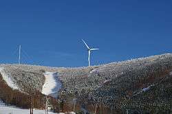
The mine closed in 1999, leaving the town to fight for survival. After several close calls, the small town has decided to fight back, in an effort to reverse the economic uncertainty that has befallen the town. This has included the creation of several large wind turbine projects, along with the diversification of the local economy, with emphasis on tourism (such as skiing in the winter months).
Demographics
Population
| Canada census – Murdochville, Quebec community profile | |||
|---|---|---|---|
| 2016 | 2011 | 2006 | |
| Population: | 651 (-14.8% from 2011) | 764 (-5.9% from 2006) | 812 (-30.7% from 2001) |
| Land area: | 61.37 km2 (23.70 sq mi) | 61.18 km2 (23.62 sq mi) | 61.18 km2 (23.62 sq mi) |
| Population density: | 10.6/km2 (27/sq mi) | 12.5/km2 (32/sq mi) | 13.3/km2 (34/sq mi) |
| Median age: | 51.8 (M: 50.3, F: 53.5) | 48.8 (M: 49.1, F: 48.6) | 47.7 (M: 47.3, F: 48.0) |
| Total private dwellings: | 512 | 508 | 552 |
| Median household income: | $63,127 | $33,013 | $37,272 |
| References: 2016[4] 2011[3] 2006[5] earlier[6] | |||
| Historical Census Data - Murdochville, Quebec[7] | |||||||||||||||||||||||||||||
|---|---|---|---|---|---|---|---|---|---|---|---|---|---|---|---|---|---|---|---|---|---|---|---|---|---|---|---|---|---|
|
|
| |||||||||||||||||||||||||||
Language
| Canada Census Mother Tongue - Murdochville, Quebec[7] | ||||||||||||||||||
|---|---|---|---|---|---|---|---|---|---|---|---|---|---|---|---|---|---|---|
| Census | Total | French |
English |
French & English |
Other | |||||||||||||
| Year | Responses | Count | Trend | Pop % | Count | Trend | Pop % | Count | Trend | Pop % | Count | Trend | Pop % | |||||
2011 |
760 |
725 | 95.39% | 30 | 3.95% | 5 | 0.66% | 0 | 0.00% | |||||||||
2006 |
805 |
725 | 90.06% | 30 | 3.73% | 0 | 0.00% | 50 | 6.21% | |||||||||
2001 |
1,175 |
1,105 | 94.04% | 35 | 2.98% | 25 | 2.13% | 10 | 0.85% | |||||||||
1996 |
1,595 |
1,485 | n/a | 93.10% | 100 | n/a | 6.27% | 10 | n/a | 0.63% | 0 | n/a | 0.00% | |||||
Climate
Murdochville has a warm-summer humid continental climate (Dfb). Summers are relatively cool and short, whereas winters are long and at times very cold with massive amounts of snowfall. The brief summers are, however, mild enough to keep September (the fourth-warmest month) right above the 10 °C (50 °F) isotherm for a humid continental climate.
| Climate data for Murdochville, Quebec | |||||||||||||
|---|---|---|---|---|---|---|---|---|---|---|---|---|---|
| Month | Jan | Feb | Mar | Apr | May | Jun | Jul | Aug | Sep | Oct | Nov | Dec | Year |
| Record high °C (°F) | 8.5 (47.3) |
15.6 (60.1) |
16.7 (62.1) |
23.5 (74.3) |
29.4 (84.9) |
33.0 (91.4) |
33.5 (92.3) |
32.8 (91.0) |
28.9 (84.0) |
24.0 (75.2) |
20.0 (68.0) |
10.6 (51.1) |
33.5 (92.3) |
| Average high °C (°F) | −9.1 (15.6) |
−7.9 (17.8) |
−1.7 (28.9) |
5.2 (41.4) |
12.5 (54.5) |
18.2 (64.8) |
21.0 (69.8) |
20.2 (68.4) |
14.3 (57.7) |
7.3 (45.1) |
0.5 (32.9) |
−5.9 (21.4) |
6.2 (43.2) |
| Daily mean °C (°F) | −13.8 (7.2) |
−12.7 (9.1) |
−6.3 (20.7) |
0.8 (33.4) |
7.5 (45.5) |
13.1 (55.6) |
16.2 (61.2) |
15.6 (60.1) |
10.2 (50.4) |
3.9 (39.0) |
−2.8 (27.0) |
−9.7 (14.5) |
1.8 (35.3) |
| Average low °C (°F) | −18.4 (−1.1) |
−17.3 (0.9) |
−11.0 (12.2) |
−3.6 (25.5) |
2.4 (36.3) |
7.9 (46.2) |
11.4 (52.5) |
10.9 (51.6) |
6.0 (42.8) |
0.5 (32.9) |
−6.0 (21.2) |
−13.5 (7.7) |
−2.6 (27.4) |
| Record low °C (°F) | −36.1 (−33.0) |
−36.7 (−34.1) |
−29.0 (−20.2) |
−22.2 (−8.0) |
−12.8 (9.0) |
−3.9 (25.0) |
1.5 (34.7) |
−1.7 (28.9) |
−6.1 (21.0) |
−15.0 (5.0) |
−21.0 (−5.8) |
−30.5 (−22.9) |
−36.7 (−34.1) |
| Average precipitation mm (inches) | 101 (4.0) |
73 (2.9) |
102 (4.0) |
80 (3.1) |
64 (2.5) |
87 (3.4) |
111 (4.4) |
96 (3.8) |
79 (3.1) |
87 (3.4) |
111 (4.4) |
127 (5.0) |
1,118 (44) |
| Average snowfall cm (inches) | 91.1 (35.9) |
68.5 (27.0) |
91.4 (36.0) |
56.7 (22.3) |
10.6 (4.2) |
0.3 (0.1) |
0.0 (0.0) |
0.1 (0.0) |
0.5 (0.2) |
23.4 (9.2) |
77.3 (30.4) |
111.5 (43.9) |
531.4 (209.2) |
| Average precipitation days | 14.8 | 12.8 | 13.9 | 12.4 | 12.3 | 13.7 | 15.0 | 13.0 | 13.5 | 13.6 | 17.4 | 17.2 | 169.6 |
| Average rainy days | 1.3 | 0.6 | 1.9 | 4.7 | 10.7 | 13.7 | 15.0 | 13.0 | 13.3 | 10.0 | 5.2 | 2.0 | 91.4 |
| Average snowy days | 14.2 | 12.5 | 12.6 | 8.3 | 2.2 | 0.1 | 0.0 | 0.0 | 0.3 | 4.8 | 13.2 | 16.2 | 84.4 |
| Source: [8] | |||||||||||||
See also
- List of cities in Quebec
References
- "Murdochville (ville)" (in French). Commission de toponymie du Québec. Retrieved 2011-12-07.
- "Murdochville". Répertoire des municipalités (in French). Ministère des Affaires municipales, des Régions et de l'Occupation du territoire. Archived from the original on 2012-06-07. Retrieved 2011-12-07.
- "2011 Community Profiles". 2011 Canadian Census. Statistics Canada. July 5, 2013. Retrieved 2014-01-28.
- "2016 Community Profiles". 2016 Canadian Census. Statistics Canada. February 21, 2017. Retrieved 2018-01-30.
- "2006 Community Profiles". 2006 Canadian Census. Statistics Canada. March 30, 2011. Retrieved 2011-12-07.
- "2001 Community Profiles". 2001 Canadian Census. Statistics Canada. February 17, 2012.
- Statistics Canada: 1996, 2001, 2006, 2011, 2016 census
- "Historical Weather for Murdochville, Quebec". Weatherbase. Retrieved July 5, 2012.
External links
- Town of Murdochville
- Tourist Information about Murdochville
- CBC Radio Story: No Company Town: The Story of Murdochville
Adjacent Municipal Subdivisions | ||||||||||
|---|---|---|---|---|---|---|---|---|---|---|
| ||||||||||
| Cities | |
|---|---|
| Municipalities | |
| Townships | |
| Unorganized Territories | |
| |
| Authority control |
|
|---|