Paternò
Paternò (Sicilian: Patennò) is a southern Italian town and comune of the Metropolitan City of Catania, Sicily. With a population (2016) of 48,009,[2] it is the third municipality of the province after Catania and Acireale.
Paternò | |
|---|---|
| Città di Paternò | |
 | |
 Coat of arms | |
.svg.png) Paternò within the Province of Catania | |
Location of Paternò 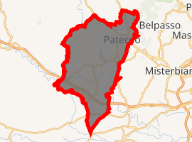
| |
 Paternò Location of Paternò in Italy 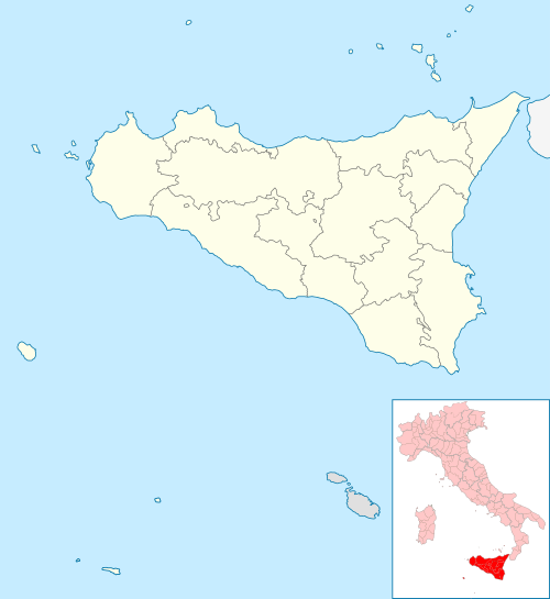 Paternò Paternò (Sicily) | |
| Coordinates: 37°34′N 14°54′E | |
| Country | Italy |
| Region | Sicily |
| Metropolitan city | Catania (CT) |
| Frazioni | Sferro |
| Government | |
| • Mayor | Nino Naso |
| Area | |
| • Total | 144.04 km2 (55.61 sq mi) |
| Elevation | 225 m (738 ft) |
| Population | |
| • Total | 48,009 |
| • Density | 330/km2 (860/sq mi) |
| Demonym(s) | Paternesi, Patornesi |
| Time zone | UTC+1 (CET) |
| • Summer (DST) | UTC+2 (CEST) |
| Postal code | 95047 |
| Dialing code | 095 |
| Patron saint | Santa Barbara and San Vincenzo Martyr |
| Saint day | December 4 |
| Website | Official website |
History
The site of Paternò was settled before 3500 BCE. Its inhabitants were probably the Sicani, although it was located in mainly Sicel territory; its initial name was Inessa. The modern name derives form the Greek Paeter Aitnaion, meaning the "Fortress of the Etnaeans". The presence of another town, called Hybla Major or Galeatis, is attested north west to the current town.
A centre of medium importance in the Greek and Roman eras, it was largely depopulated in the three centuries before 1000 AD; during the subsequent Arab domination of Sicily, it was known as Batarnù. After the Norman conquest in the 1040s, it was renamed Paternionis and began a period of flourishing. It was here that King Frederick III of Sicily created the Camera Reginale ("Queen's Chamber") as a wedding gift for his wife Eleanor of Anjou, and this was inherited by the subsequent Queens of Sicily. This period of splendour for Paternò lasted until the 15th century, when it became a fief and in consequence slowly lost importance.
Historically, the area around Paternò was plagued by malaria, caused by the marshlands of the Plain of Catania. This has since long been remedied, and the urban development of the town enjoyed a large acceleration in the 1960s and 1970s.
Geography
Paternò borders with the municipalities of Belpasso, Biancavilla, Catenanuova (EN), Centuripe (EN), Ragalna, Ramacca and Santa Maria di Licodia.[4] Its only hamlet (frazione) is the village of Sferro.[5]
Within Paterno there is a geologic feature named 'Salinelle', a place where small mud volcanoes emerge from cracks in the ground.[6] This area in which the Salinelle surfaces includes an archeological site currently uncovering evidence of Roman baths previously built on and thought to have used the Salinelle mud.
Main sights
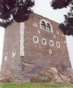
- The Norman Castle, built in 1072 by order of Roger I of Sicily.
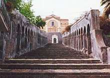
- Mother Church (Chiesa Madre di Santa Maria dell'Alto), built in 1342 and largely modified in the early 18th century. It is connected by a scenic staircase to the Porta del Borgo
- San Francesco alla Collina (1346), with a church in Gothic style and remains of Baroque decorations.
- Rococo church of Cristo al Monte.
- Church of St.Catherine of Alexandria
- Santa Maria della Valle di Iosaphat, commissioned in 1072 by Adelaide del Vasto, with a precious Gothic portal.
- Associazione Culturale Paternesi.com, a cultural association born in November 2002, from an idea of Giorgio Ciancitto, to take care of the city of Paternò around the world.
- The Paterno Salinelle site.
Transportation
Paternò is served by three state roads leading to Catania, Randazzo and Troina areas.
The tran station was originally used mostly for food transportation, and is not out of service. The main passenger station is part of the narrow gauge Ferrovia Circumetnea. The latter also provides a regular bus service to destination on the Catania-Adrano line.
Twin towns


References
- "Superficie di Comuni Province e Regioni italiane al 9 ottobre 2011". Istat. Retrieved 16 March 2019.
- (in Italian) Source: ISTAT 2016
- "Popolazione Residente al 1° Gennaio 2018". Istat. Retrieved 16 March 2019.
- 39262 Paternò on OpenStreetMap
- 2209979969 Sferro on OpenStreetMap
- Chisari, Mimmo. Paterno: the Pearl of the Simeto Valley. Paterno: Hibla Ink.
External links
| Wikimedia Commons has media related to Paternò. |
- Chisholm, Hugh, ed. (1911). . Encyclopædia Britannica. 20 (11th ed.). Cambridge University Press. p. 911.
| Authority control |
|
|---|