Panchkula
Panchkula is a planned city and District Headquarter in the Panchkula district, Haryana, India.The origin of the name Panchkula came from the place where five irrigation canals meet. It forms a part of an adjoining area to the Chandigarh, Mohali and Zirakpur. It is approximately 4 km (2.4 miles) southeast of Chandigarh, 105 km (65 miles) southwest of Shimla, 44 km (27 miles) from Ambala and 259 km (162 miles) northeast of New Delhi, the national capital. It is a part of the Chandigarh capital region or Greater Chandigarh. The Chandigarh-Mohali-Panchkula metropolitan region collectively forms a Chandigarh Tricity, with a combined population of over 2 million.
Panchkula | |
|---|---|
City | |
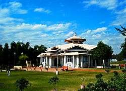 Yagya Shala, within the Mansa Devi temple complex in Panchkula | |
| Nickname(s): Chandigarh Tricity | |
 Panchkula Location in Haryana, India  Panchkula Panchkula (India) | |
| Coordinates: 30.74°N 76.80°E | |
| Country | |
| State | Haryana |
| District | Panchkula |
| Government | |
| • Type | Municipality |
| • Body | Municipal Corporation Panchkula |
| • Mayor | Upinder Kaur Ahluwalia[1][2] (INC) |
| Area | |
| • Total | 89 km2 (34 sq mi) |
| Elevation | 365 m (1,198 ft) |
| Population (2011)[3] | 211,355 |
| 2011 Census | |
| Languages | |
| • Official | Hindi, English, Punjabi |
| • Spoken | Hindi, Punjabi |
| Time zone | UTC+5:30 (IST) |
| PIN | 134 109 - 134 116 |
| Telephone code | +91-172-XXX-XXXX |
| ISO 3166 code | IN-HR |
| Vehicle registration | HR-03 |
| Website | panchkula |
The city hosts the Chandimandir Cantonment, the headquarters of the Western Command of the Indian Army. In 2011, Panchkula city had a population of 211,355 of which male and female were 111,731 and 99,624 respectively. It is one of the planned cities in India like Chandigarh with a Sector System.
History
The city is named after Panchkula village that is situated on the Ambala Kalka highway, near the junction with the Chandigarh road. The city was planned and developed by the state of Haryana in the 1970s. Panchkula was supposed to be the capital.
Etymology
The word is derived from the local word panch (Sanskrit: पंच) (five) and kula (Sanskrit: कुला) (canals) "The city of 5 canals", possibly referring to five irrigation canals that distribute water from the Ghaggar-Hakra River.[4]
The Ramgarh Fort
The fort was built by the Rajput rulers of Kahlur State, headquarter of which was Bilaspur in Himachal Pradesh. King of Bilaspur built the Ramgarh Fort 360 years ago.[5] In 1687, its rulers offered Guru Gobind Singh a horse, a sword and Rs 500000 when he was relocating his troops from Paonta Sahib to Anandpur Sahib after the Battle of Bhangani. In the 1750s, it fell to eventually a fief to Sirmur State, but became independent in 1804. It is currently occupied by the progeny of Kalee Chand, younger son of King of Bilaspur Sangar Chand (r. 1197-1220), and run as a heritage hotel.
Sikh sites
Nada Sahib (named after Nada Shah who was a disciple of Guru Gobind Singh, 2 km south east of Panchkula), Lakhnaur Sahib (native place of Mata Gujri mother of Guru Gobind Singh, has a charpai belonging to Guru Gobind Singh, 6 kilometres south of Ambala), Panjokhra Sahib (visited by the 8th guru of Sikhs Guru Har Krishan, 8 km east of Ambala) and Haryoli (temple of Rishis Markandeya hold an annual fair in September–October where he meditated to lord Shiva at the age of 12, located 15 km to southeast of Ambala Cantt) are the popular ancient religious sites.[6]
Geography and climate
Panchkula district has a sub-tropical continental monsoon climate having, hot summers, cool winters, good monsoon rainfall. It has great variation in temperature (-1 °C to 43 °C). Sometimes winter frost occurs during December and January. The district also receives winter rains from the western disturbance. The rainfall is mostly received in the monsoon. Morni hills constitute the highest point of the district as well as of Haryana. The Ghaggar is the only perennial river, which is very shallow outside of the monsoons. The mountains and hills of Kasauli are clearly visible from Panchkula.
Generally, the slope of the district is from north east to south west and in this direction, most of the rivers/streams rain-fed torrents flow down and spread much gravel and pebbles in their beds. Only the Sirsa river, in Kalka Tehsil flows towards the north-west. The soils in the district are mainly light loam.
The underground water in the district is generally fresh and suitable for domestic and irrigation purposes. The underground water level is generally high in the southern parts and low in north and north-east which is hilly tract. The district lies in the Himalayas boundary fault zones and earthquakes of moderate to high intensity have occurred in the past.
Average temperature
- Spring: It lasts from February-end to early-April. Temperatures vary between (max) 13 °C to 20 °C and (min) 5 °C to 12 °C.
- Autumn: In autumn (from September-end to mid-November.), the temperature may rise to a maximum of 30 °C. Temperatures usually remain between 10° to 22° in autumn. The minimum temperature is around 6 °C.
- Summer: The temperature in summer (from mid-April to June-end) may rise even above 40 °C. Temperatures generally remain between 30 °C to 39 °C (94 – 101F).
- Monsoon: During monsoon (from early-July to mid-September), Panchkula receives moderate to heavy rainfall and sometimes heavy to very heavy rainfall (generally during the month of August or September). Usually, the rain-bearing monsoon winds blow from south-west/south-east. Mostly, the city receives heavy rain from the south (which is mainly a persistent rain) but it generally receives most of its rain during monsoon either from North-west or North-east. The maximum amount of rain received by the city of Panchkula during monsoon season is 195.5 mm in a single day.
- Winter: Winters (November-end to February-end) are mild but it can sometimes get quite chilly in Panchkula. Average temperatures in the winter remain at (max) 5 °C to 14 °C and (min) -1 °C to 5 °C. Rain usually comes from the west during winters and it is usually a persistent rain for 2–3 days with sometimes hail-storms.[7]
Demographics
According to the 2011 Census of India, the people of the city are mainly Punjabi Hindu, with substantial Sikh and Muslim minorities.[8] Despite being a part of the Hindi-speaking Haryana, a plurality of the City's population speaks Punjabi as a first language.[9]
Employment
Panchkula IT Park (also known as Haryana State Industrial and Infrastructural Development Corporation Technology Park) is the state of art infrastructure to facilitate information technology in the city. It spreads over 74 acres developed by HSIIDC situated in sector 22 (foothills of Shivalik Hills or outer Himalayas and on the banks of Ghaggar River). It is well connected to Delhi, Haryana, Punjab and Himachal Pradesh, and the IT businesses looking for office space in the area.
Tourism
There are various visitor attractions including:

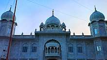
- Mata Mansa Devi Mandir is one of the most prominent temples in North India and is dedicated to Goddess Mansa Devi, a form of Shakti.
- Bhima Devi Temple Site Museum nicknamed Khajuraho of North India for its erotic sculptures, comprises the restored ruins of an ancient Hindu temple dating from between 8th and 11th century AD.
- Nada Sahib is a Sikh Gurudwara in the Panchkula district of the Indian state of Haryana. Situated on the banks of the Ghaggar-Hakra River in the Sivalik Hills.
- Morni, the hill resort at Morni Hills, an offshoot of the Sivalik Hills, are about 45 kilometres (28 mi) from the city. The hills were named for Queen Morni, who is said to have ruled this city.
- Pinjore Gardens, also known as Yadavindra Gardens, are about 20 km (12 mi) from the city, and cover a total area of 100 hectares (250 acres). The work of creating the gardens began in the seventeenth century. Pinjore Gardens is the venue for an annual mango festival. The garden houses a mini zoo, historic places, Japanese garden, nursery and a number of picnic spots. According to Hindu theology, the Pandava brothers rested in Pinjore during their exile.
- National Cactus and Succulent Botanical Garden and Research Centre a 7 acres (2.8 ha) cactus garden in the center of Panchkula, was established in 1987, and is known for its rare and endangered species of Indian succulent plants.
- Kaushalya Dam is an earth-filled barrage dam on Kaushalya river in Pinjore. It is an important wetland that is home to many endangered migratory birds.
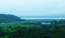 Kaushalya Dam
 - Jayanti Devi Temple, Bir Shikargah Wildlife Sanctuary, Khol Hi-Raitan Wildlife Sanctuary, Pheasant Breeding Centre, Morni, Jatayu Conservation Breeding Centre, Pinjore, Pheasant Breeding Centre, Berwala
Sports
Panchkula has its own Sports Complex in Sector 3 includes Tau Devi Lal Cricket Stadium, Panchkula Golf Course, Olympic Athletic Track and other multi-purpose facilities for sports.
Tau Devi Lal Cricket Stadium has a cricket stadium, badminton hall, football ground, athletic Track and accommodation facilities for the sportspersons. To use this sports facility there is a nominal fee for each game of your interest. It is situated in sector 3 adjoining sector 21.
Panchkula Golf Course Set up in 2003 over a 135-acre, this 18 hole golf course located in sector 3 adjoining sector 21 in the foothills of Shivalik Hills on the banks of Ghaggar River, just off the Himalayan Expressway.
Administration
Panchkula has branch offices for a number of state government agencies including: Haryana Urban Development Authority, Central Board of Secondary Education Regional Office, Haryana Staff Selection Commission, Haryana State Commission For Women, Haryana Forest Development Corporation Limited, Haryana Agro Industries Corporation Limited, Women and Child Development Department - Haryana, Directorate of Urban Local Bodies, Haryana Police Recruitment Board, Haryana Electricity Regulatory Commission, Haryana Finance Commission, Yojana Bhawan - Haryana, Public Health Engineering Department, Haryana, Haryana State Technical Education Society, Haryana State Health Resource Centre, Directorate of Medical Education & Research - Haryana, National Health Mission - Haryana, Haryana State Federation of Co-operative Sugar Mills Limited, Office of the Commissioner of Income Tax - Haryana, Department Science & Technology - Haryana, Haryana State Cooperative Agriculture And Rural Development Bank Limited, The Haryana State Co-Operative Apex Bank Limited, The Haryana State Cooperative Labour & Construction Federation Limited, Confed-The Haryana State Federation of Consumers, Haryana State Warehousing Corporation, Pashudhan Bhawan - Haryana, Haryana Seed Development Corporation Limited, Sinchai Bhawan - Haryana, Vanijya Bhawan - Excise & Taxation Department, Haryana, Department of Technical Education, Regional Transport Authority, District Education Office, Regional Employment Office, Education Department Headquarters, Shiksha Sadan and Utkarsh Society.
Education
Dental Colleges
- BRS Dental College and Hospital, Sultanpur, Panchkula
- Swami Devi Dayal Dental College, Barwala, Panchkula
Engineering College
- Panchkula Engineering College, Mauli, Panchkula
General degree Colleges
- Government College, Sector 1, Panchkula
- Government College, Kalka, Panchkula
- Government College for Girls, Sector 14, Panchkula
- Mother Teresa Saket College of Physiotherapy, Chandimandir Cantonment, Panchkula
Polytechnic College
- Government Polytechnic for Women, Morni Hills, Panchkula
Other
- Haryana Institute of Civil Aviation, Pinjore, Panchkula
- Institute For Spatial Planning And Environment Research, Amravati Enclave, Panchkula
- National Institute of Fashion Technology, Sector 26, Panchkula
- National Institute For Training in Search Rescue And Disaster Response, Bhanu, Panchkula
CBSE affiliated schools
- Amrawati Vidyalaya, Pinjore
- Army Public School Chandimandir Cantt (APS)
- Bhawan Vidyalaya, Sector 15
- Blue Bird, Sector 16
- CL DAV, Sector 11
- DAV Public School, Sector 8
- DC Model Senior Secondary School
- Delhi Public School, Pinjore
- Doon Public School, Sector 21
- Hallmark Public School, Sector 15
- Hansraj Public School, Sector 6
- Haryana Model School, Sector 10
- Holy Child School, Morni Road
- Jainendra Public School, Sector 1
- Kendriya Vidyalaya No. 1 Chandimandir Cantt (KV1)
- Kendriya Vidyalaya No. 2 Chandimandir Cantt (KV2)
- Kendriya Vidyalaya, GC CRPF Pinjore
- Kendriya Vidyalaya, ITBP Bhanu
- Manav Mangal School, Sector 11
- New India Smart School, Sector 15
- St. Soldier Divine Public School, Sector 16
- Satluj Public School, Sector 4
- Shishu Niketan, MDC, Sector 5
- The British School Panchkula, Sector 8
- The Gurukul, Sector 20
- The Sky World School, Sector 21
CISCE affiliated schools
- Little Flower Convent School, Sector 14
- St. Xavier's High School, Sector 20
- Saupin's School, Sector 9
Healthcare
There are a number of super specialty hospitals.
- General Hospital in Sector 6.
- Command Hospital in Chandimandir Cantonment.
- Saket Orthopedic Hospital in Sector 1.
- Government dispensaries are also present in some sectors.
Some major multi specialty private hospitals are:
- Alchemist Hospital Sector 21.
- Ivy Hospital Sector 5-C MDC.
- Paras Hospital, HSIIDC Park, Sector 22.
- Wings Hospital Sector 25.
- Ojas Hospital, Sector 26
Paras Bliss Hospital Sector 5 MDC. Alchemist Eye Institute Sector 21. Kare Partners Mother And Child Hospital Sector 2. Raffles Hospital Sector 14. Dhawan Hospital Sector 7. Drishti Eye Hospital Sector 11. Chakravarty Nursing Home Sector 10. Institute of Reproduction & Child Cares Sector 17. Phoenix Hospital Sector 16. Happy Family Hospital Sector 5 MDC. Gokul Surgical Hospital Sector 15. Malhotra Super Speciality Hospital Sector 25. Noheria Nursing Home Sector 8. Jindal Nursing Home Sector 17. Mirchia Hospital Sector 15. Clove Dental Sector 20. Sunny Hospital Sector 4. Orthomax Hospital Sector 15. Blessings Hospital Sector 15. Mind Peace Clinic Sector 14.
Government Pet Animal Medical Centre Cum Teaching Hospital, Sector-3, Panchkula.
- Ved Prakash Malik - Four star general who commanded the Indian Army during the Kargil War[10]
- Ayushmann Khurrana - Indian actor, singer, and television host.
- Aparshakti Khurana - Indian actor, radio jockey and a television host.
- Sargun Mehta - Indian actress.
- Manan Vohra — cricketer
- ruchika girhotra - budding tennis player, died young
- Rekha Sharma(politician) Chairperson of the National Commission for Women in India
See also
- Ajitgarh
- Amar Ujala
- Chandigarh
- Indian special forces training school
- Zirakpur
References
- Saini, Manveer (5 July 2013). "Upinder Walia is 1st mayor of Panchkula MC". The Times of India. Retrieved 13 October 2015.
- "Ahluwalia is Panchkula's first woman Mayor". Indian Express. Retrieved 13 October 2015.
- "Census of India Search details". censusindia.gov.in. Retrieved 10 May 2015.
- "Haryana Review 2013, page 30" (PDF). Archived from the original (PDF) on 8 May 2016. Retrieved 18 April 2016.
- Haryana Samvad Archived 29 November 2018 at the Wayback Machine, Oct 2018, p38-40.
- Haryana Gazetteer, Revenue Dept of Haryana, Capter-V.
- "World Weather Information Service - Chandigarh". wmo.int.
- http://www.census2011.co.in/census/city/29-panchkula.html
- The total population of panchkula as of 2020 is 6.27 Lakhs "Badal wants back Punjabi speaking areas of Haryana from new BJP govt - Times of India". The Times of India. Retrieved 28 November 2018.
- "Panchkula: 'City of Generals' gets 2 more after 'farewell to arms'". The Times of India. Retrieved 17 January 2017.
External links
| Wikimedia Commons has media related to Panchkula. |