Orono, Maine
Orono (/ˈɒrənoʊ/) is a town in Penobscot County, Maine, United States. Located on the Penobscot and Stillwater rivers, it was first settled by British-American colonists in 1774. They named it in honor of Chief Joseph Orono, a sachem of the indigenous Penobscot nation who long occupied this territory.
Town of Orono | |
|---|---|
Town | |
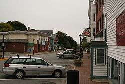 Mill Street business in downtown Orono | |
 Seal | |
 | |
| Coordinates: 44.883°N 68.672°W | |
| Country | United States |
| State | Maine |
| County | Penobscot |
| Settled | 1774 |
| Incorporated | March 12, 1806 |
| Chartered | 1969 |
| Government | |
| • Type | Council/Manager |
| • Town Manager | Sophia L. Wilson |
| Area | |
| • Total | 19.60 sq mi (50.76 km2) |
| • Land | 18.19 sq mi (47.11 km2) |
| • Water | 1.41 sq mi (3.65 km2) 7.19% |
| Population | |
| • Total | 10,362 |
| • Estimate (2016) | 11,242 |
| • Density | 569.7/sq mi (220.0/km2) |
| Time zone | UTC-5 (EST) |
| • Summer (DST) | UTC-4 (EDT) |
| ZIP Code | 04473-Town, 04469-UMaine |
| Area code(s) | 207 |
| Website | www.orono.org |
In the nineteenth century, the town became a center of the lumber industry. Sawmills on the rivers were powered by the water, and logs were floated downriver on the Penobscot for shipping and export from coastal ports.
Since 1865 it has been the location of the University of Maine, established as a land-grant institution and the state's flagship educational institution. In the fall of 2018, the university enrolled 11,404 students at Orono. Not including university residents, the town's population was 10,362 at the 2010 census.
Geography
According to the United States Census Bureau, the town has a total area of 19.60 square miles (50.76 km2), of which, 18.19 square miles (47.11 km2) of it is land and 1.41 square miles (3.65 km2) is water.[1] The town is divided by the Stillwater River, a branch of the Penobscot River. It occupies part of Marsh Island, which is surrounded by the Penobscot and the Stillwater rivers, and the remainder of the town is on the mainland. The Orono Dam impounds the Stillwater River at its confluence with the Penobscot River near downtown Orono.[3]
Climate
This climatic region is typified by large seasonal temperature differences, with warm to hot (and often humid) summers and cold (sometimes severely cold) winters. Orono has a warm-summer humid continental climate, according to the Köppen Climate Classification system is "Dfb", thus abbreviated ed in on climate maps.[4]
| Climate data for Orono (University of Maine), elevation: 47 m or 154 ft, 1981-2010 normals, extremes and average extremes 1893-2005[lower-alpha 1] | |||||||||||||
|---|---|---|---|---|---|---|---|---|---|---|---|---|---|
| Month | Jan | Feb | Mar | Apr | May | Jun | Jul | Aug | Sep | Oct | Nov | Dec | Year |
| Record high °F (°C) | 65 (18) |
63 (17) |
83 (28) |
89 (32) |
99 (37) |
100 (38) |
102 (39) |
104 (40) |
97 (36) |
90 (32) |
78 (26) |
64 (18) |
104 (40) |
| Mean maximum °F (°C) | 46.2 (7.9) |
46.7 (8.2) |
58.2 (14.6) |
72.2 (22.3) |
83.8 (28.8) |
89.5 (31.9) |
92.0 (33.3) |
90.1 (32.3) |
84.3 (29.1) |
73.7 (23.2) |
60.8 (16.0) |
49.5 (9.7) |
92.0 (33.3) |
| Average high °F (°C) | 28.7 (−1.8) |
33.6 (0.9) |
41.5 (5.3) |
54.5 (12.5) |
67.3 (19.6) |
76.0 (24.4) |
81.0 (27.2) |
79.6 (26.4) |
70.3 (21.3) |
56.9 (13.8) |
44.8 (7.1) |
33.5 (0.8) |
55.6 (13.1) |
| Daily mean °F (°C) | 19.9 (−6.7) |
24.2 (−4.3) |
32.4 (0.2) |
44.5 (6.9) |
55.9 (13.3) |
64.5 (18.1) |
70.0 (21.1) |
68.8 (20.4) |
59.8 (15.4) |
48.0 (8.9) |
38.1 (3.4) |
26.4 (−3.1) |
46.0 (7.8) |
| Average low °F (°C) | 11.1 (−11.6) |
14.8 (−9.6) |
23.3 (−4.8) |
34.5 (1.4) |
44.4 (6.9) |
53.0 (11.7) |
59.0 (15.0) |
57.9 (14.4) |
49.3 (9.6) |
39.2 (4.0) |
31.4 (−0.3) |
19.4 (−7.0) |
36.4 (2.5) |
| Mean minimum °F (°C) | −14.8 (−26.0) |
−12.9 (−24.9) |
−1.18 (−18.43) |
19.1 (−7.2) |
29.1 (−1.6) |
37.7 (3.2) |
45.4 (7.4) |
41.3 (5.2) |
31.0 (−0.6) |
23.0 (−5.0) |
10.9 (−11.7) |
−8 (−22) |
−14.8 (−26.0) |
| Record low °F (°C) | −40 (−40) |
−32 (−36) |
−25 (−32) |
3 (−16) |
19 (−7) |
29 (−2) |
34 (1) |
30 (−1) |
22 (−6) |
13 (−11) |
−8 (−22) |
−31 (−35) |
−40 (−40) |
| Average precipitation inches (mm) | 2.98 (76) |
2.48 (63) |
3.15 (80) |
3.13 (80) |
3.41 (87) |
3.52 (89) |
3.01 (76) |
3.27 (83) |
3.56 (90) |
3.64 (92) |
4.03 (102) |
4.21 (107) |
40.39 (1,025) |
| Average snowfall inches (cm) | 18.7 (47.5) |
17.8 (45.2) |
11.3 (28.7) |
3.9 (9.9) |
0.2 (0.5) |
0.0 (0.0) |
0.0 (0.0) |
0.0 (0.0) |
0.0 (0.0) |
trace | 0.4 (1) |
4.6 (11.7) |
56.9 (144.5) |
| Average precipitation days | 10 | 8 | 9 | 9 | 10 | 10 | 9 | 9 | 9 | 9 | 10 | 9 | 111 |
| Average snowy days | 6.3 | 4.5 | 4.3 | 1.2 | trace | 0.0 | 0.0 | 0.0 | 0.0 | 0.1 | 1.4 | 4.6 | 22.4 |
| Average relative humidity (%) | 70 | 68 | 65 | 61 | 65 | 70 | 71 | 71 | 74 | 72 | 72 | 75 | 70 |
| Mean daily sunshine hours | 6.2 | 4.1 | 5.5 | 5.4 | 6.5 | 5.9 | 7.5 | 9.4 | 9.8 | 9.0 | 6.5 | 6.9 | 6.9 |
| Source: WRCC,[5] Weatherbase (snowfall, precipitation and snow days),[6] Meteoblue (sun days)[7] and timeanddate.com (humidity)[8] | |||||||||||||
| Climate data for Orono (University of Maine), elevation: 47 m or 154 ft, 1961-1990 normals and average extremes | |||||||||||||
|---|---|---|---|---|---|---|---|---|---|---|---|---|---|
| Month | Jan | Feb | Mar | Apr | May | Jun | Jul | Aug | Sep | Oct | Nov | Dec | Year |
| Mean maximum °F (°C) | 34.8 (1.6) |
42.2 (5.7) |
47.2 (8.4) |
56.4 (13.6) |
72.3 (22.4) |
79.3 (26.3) |
85.7 (29.8) |
81.2 (27.3) |
75.1 (23.9) |
61.8 (16.6) |
48.5 (9.2) |
40.3 (4.6) |
85.7 (29.8) |
| Average high °F (°C) | 27.0 (−2.8) |
29.1 (−1.6) |
38.8 (3.8) |
50.7 (10.4) |
64.2 (17.9) |
73.6 (23.1) |
79.2 (26.2) |
76.3 (24.6) |
66.4 (19.1) |
54.9 (12.7) |
41.9 (5.5) |
30.4 (−0.9) |
52.7 (11.5) |
| Daily mean °F (°C) | 17.2 (−8.2) |
19.2 (−7.1) |
29.8 (−1.2) |
40.8 (4.9) |
52.3 (11.3) |
61.7 (16.5) |
67.5 (19.7) |
64.9 (18.3) |
55.8 (13.2) |
45.3 (7.4) |
34.7 (1.5) |
21.9 (−5.6) |
42.6 (5.9) |
| Average low °F (°C) | 7.5 (−13.6) |
9.3 (−12.6) |
20.8 (−6.2) |
30.9 (−0.6) |
40.6 (4.8) |
49.6 (9.8) |
55.6 (13.1) |
53.8 (12.1) |
45.0 (7.2) |
36.0 (2.2) |
27.5 (−2.5) |
13.6 (−10.2) |
32.5 (0.3) |
| Mean minimum °F (°C) | −1.5 (−18.6) |
−0.4 (−18.0) |
12.9 (−10.6) |
27.2 (−2.7) |
34.6 (1.4) |
46.6 (8.1) |
49.2 (9.6) |
46.3 (7.9) |
37.9 (3.3) |
32.3 (0.2) |
21.9 (−5.6) |
−2.1 (−18.9) |
−2.1 (−18.9) |
| Average precipitation inches (mm) | 2.87 (72.9) |
2.63 (66.8) |
2.74 (69.6) |
3.00 (76.2) |
3.43 (87.1) |
3.41 (86.6) |
3.52 (89.4) |
3.48 (88.4) |
3.56 (90.4) |
3.28 (83.3) |
4.05 (102.9) |
3.82 (97.0) |
39.79 (1,010.6) |
| Source: NOAA[9] and WRCC (average extremes)[10] | |||||||||||||
Conservation
The Orono Land Trust operates a number of protected areas in Orono. Piney Knoll Conservation Area, situated alongside the Penobscot River, is known for its walking trails and bird-watching. The University of Maine also owns a considerable amount of protected land in the town. Prominent parcels include Dwight B. Demeritt Forest.
Demographics
| Historical population | |||
|---|---|---|---|
| Census | Pop. | %± | |
| 1810 | 351 | — | |
| 1820 | 415 | 18.2% | |
| 1830 | 1,472 | 254.7% | |
| 1840 | 1,521 | 3.3% | |
| 1850 | 2,785 | 83.1% | |
| 1860 | 2,533 | −9.0% | |
| 1870 | 2,888 | 14.0% | |
| 1880 | 2,245 | −22.3% | |
| 1890 | 2,790 | 24.3% | |
| 1900 | 3,257 | 16.7% | |
| 1910 | 3,555 | 9.1% | |
| 1920 | 3,133 | −11.9% | |
| 1930 | 3,338 | 6.5% | |
| 1940 | 3,702 | 10.9% | |
| 1950 | 7,504 | 102.7% | |
| 1960 | 8,341 | 11.2% | |
| 1970 | 9,989 | 19.8% | |
| 1980 | 10,578 | 5.9% | |
| 1990 | 10,573 | 0.0% | |
| 2000 | 9,112 | −13.8% | |
| 2010 | 10,362 | 13.7% | |
| Est. 2014 | 10,670 | [11] | 3.0% |
| U.S. Decennial Census[12] | |||
2010 census
As of the census[2] of 2010, there were 10,363 people, 2,831 households, and 1,229 families living in the town. The population density was 569.7 inhabitants per square mile (220.0/km2). There were 3,089 housing units at an average density of 169.8 per square mile (65.6/km2). The racial makeup of the town was 93.7% White, 1.2% African American, 1.1% Native American, 1.9% Asian, 0.4% from other races, and 1.7% from two or more races. Hispanic or Latino of any race were 1.5% of the population.
There were 2,831 households of which 17.8% had children under the age of 18 living with them, 32.9% were married couples living together, 7.0% had a female householder with no husband present, 3.5% had a male householder with no wife present, and 56.6% were non-families. 30.6% of all households were made up of individuals and 11.9% had someone living alone who was 65 years of age or older. The average household size was 2.29 and the average family size was 2.77.
The median age in the town was 21.8 years. 8.6% of residents were under the age of 18; 55.9% were between the ages of 18 and 24; 12.2% were from 25 to 44; 13.1% were from 45 to 64; and 10.4% were 65 years of age or older. The gender makeup of the town was 51.8% male and 48.2% female.
2000 census
As of the census[13] of 2000, the town had a population of 9,112 people, 2,691 households, and 1,291 families living in the town. The population density was 500.3 people per square mile (193.2/km²). There were 2,899 housing units at an average density of 159.2 per square mile (61.5/km²). The racial makeup of the town was 93.54% White, 1.38% Black or African American, 0.95% Native American, 2.39% Asian, 0.07% Pacific Islander, 0.52% from other races, and 1.15% from two or more races. Hispanic or Latino of any race were 1.21% of the population.
There were 2,691 households out of which 21.7% had children under the age of 18 living with them, 36.6% were married couples living together, 8.5% had a female householder with no husband present, and 52.0% were non-families. 31.5% of all households were made up of individuals and 10.0% had someone living alone who was 65 years of age or older. The average household size was 2.23 and the average family size was 2.81.
In the town, the population was spread out with 11.9% under the age of 18, 47.9% from 18 to 24, 17.1% from 25 to 44, 13.8% from 45 to 64, and 9.3% who were 65 years of age or older. The median age was 22 years. For every 100 females, there were 102.5 males. For every 100 females age 18 and over, there were 102.1 males.
The median income for a household in the town was $30,619, and the median income for a family was $52,714. Males had a median income of $35,923 versus $24,943 for females. The per capita income for the town was $14,813. About 10.3% of families and 25.0% of the population were below the poverty line, including 21.8% of those under the age of 18 and 6.2% of those 65 and older were living below the poverty line.
Notable people

- Charles J. Dunn, Chief Justice of the Maine Supreme Judicial Court
- Wallace Rider Farrington, territorial governor of Hawaii
- Merritt Lyndon Fernald (1873–1950), botanist
- Constance Hunting, poet, publisher
- Frances Laughton Mace, poet
- Jonathan Norcross, inventor, 4th mayor of Atlanta
- Elizabeth Schneider, state senator
- Katee Stearns, Miss Maine USA (2006)
- Joseph B. Treat, Wisconsin politician
- Nathaniel Treat, Maine politician
- Nathaniel B. Treat, Wisconsin politician
- Eva Valesh (1866–1956), labor journalist
- Israel Washburn, Jr., US congressman, a founder of the Republican Party, 29th Governor of Maine
- Dorothy Clarke Wilson, novelist, playwright
Points of interest
Notes
- The 30-year period (normal) is for WRCC data only.
References
- "US Gazetteer files 2010". United States Census Bureau. Retrieved 2012-12-16.
- "U.S. Census website". United States Census Bureau. Retrieved 2012-12-16.
- "Orono Dam". Geographic Names Information System. United States Geological Survey. Retrieved December 18, 2012.
- Climate Summary for Orono, Maine
- "ORONO, MAINE - Climate Summary". wrcc.dri.edu. Retrieved 2019-06-21.
- "Orono, Maine Travel Weather Averages (Weatherbase)". Weatherbase. Retrieved 2019-06-21.
- "meteoblue - weather close to you". www.meteoblue.com. Retrieved 2019-06-21.
- "Climate & Weather Averages in University of Maine at Orono Historic District, Maine, USA". www.timeanddate.com. Retrieved 2019-06-21.
- "Orono (00176430) - NOAA Weather Station". NOAA. Retrieved June 24, 2019.
- "ORONO, MAINE - Climate Summary". wrcc.dri.edu. Retrieved 2019-06-24.
- "Annual Estimates of the Resident Population for Incorporated Places: April 1, 2010 to July 1, 2014". Archived from the original on May 23, 2015. Retrieved June 4, 2015.
- "Census of Population and Housing". Census.gov. Retrieved June 4, 2015.
- "U.S. Census website". United States Census Bureau. Retrieved 2008-01-31.
External links
| Wikimedia Commons has media related to Orono, Maine. |
Municipalities and communities of Penobscot County, Maine, United States | ||
|---|---|---|
| Cities | 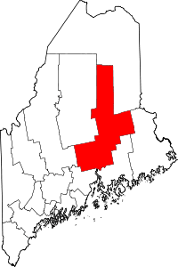 Penobscot County map | |
| Towns |
| |
| Plantations | ||
| Unorganized territories | ||
| CDPs | ||
| Other villages | ||
| Indian reservation | ||