Pushaw Lake
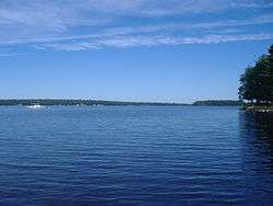
Pushaw Lake is a shallow, warmwater lake in Penobscot County, Maine, United States about 6.5 miles (10.5 km) north of downtown Bangor and 4.5 mi (7.2 km) west of downtown Orono. The lake is part of the towns of Orono, Old Town, Hudson, and Glenburn. There are roads and private residences along much of the lake, except the southeastern side where the Caribou Bog complex borders the lake. A small dam was constructed in 1920 at the lake's outflow to maintain constant water levels. The lake's formation and history prior to 1920 remains unclear. The formation of Pushaw Lake was likely caused by glacial melting, however, some locals believe that the lake was greatly expanded in size by flooding or man-made causes at some point in history, explaining the lake's shallow depth.[2][3][4]
| Pushaw Lake | |
|---|---|
 | |
| Location | Penobscot County, Maine, United States |
| Coordinates | 44.933027°N 68.801013°W[1] |
| Lake type | Reservoir[1] |
| Primary inflows | Pushaw Stream and others |
| Primary outflows | Pushaw Stream to Penobscot River |
| Basin countries | United States |
| Max. length | 7.6 mi (12.2 km) |
| Max. width | 2.3 mi (3.7 km) |
| Surface area | 4,680 acres (1,890 ha) |
| Average depth | 11 ft (3.4 m) |
| Max. depth | 33 ft (10 m) |
| Water volume | 53,102 acre foot (65,500,000 m3) |
| Surface elevation | 115 ft (35 m)[1] |
| Islands | 14+ |
External links
References
- "Pushaw Lake". Geographic Names Information System. United States Geological Survey. Retrieved December 18, 2012.
- Pushaw Lake, ME (Map). USGS.
|access-date=requires|url=(help) - "Pushaw Lake" (PDF). Maine Department of Inland Game and Fisheries. Retrieved December 18, 2012.
- "Pushaw Lake". Maine Fish Finder. Retrieved December 18, 2012.